Maps of okres Klatovy

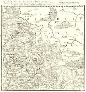
Proponit exteriores Præfecturas Dicasterio Straubingensi Subjectas cum limitibus Regni Bohemiæ adjacentis
1 : 150000 Mollova mapová sbírka Buna, Wilhelm C. Broenner, Heinrich Ludwig
Generální mapa Protektorátu Čechy a Morava

Prachiner Kreis
Prácheňsko (Česko) Berndt, Johann Christoph
[Prachiner Kreis]
Prácheňsko (Česko) Berndt, Johann Christoph
Prachiner Kreis
Prácheňsko (Česko) Berndt, Johann Christoph
Prachiner Kreis
Prácheňsko (Česko) Berndt, Johann Christoph
Prachiner Kreis
Prácheňsko (Česko) Berndt, Johann Christoph
II. vojenské mapování 29
1 : 144000
Müllerova mapa Čech
1 : 132000
Generální mapa okresních hejtmanství
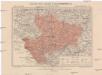
Generální mapa okresního hejtmanství Klatovského
1 : 220000 Klatovy-oblast (Česko) Wagner, Jan Eduard F. Kytka
Schuttenhofen und Winterberg.
from Spezialkarte der osterreichisch-ungarischen Monarchie.
Eisenstein und Viechtach.
from Spezialkarte der osterreichisch-ungarischen Monarchie.
166. Hirschbach, uit: Topographische Uebersichtskarte des Deutschen Reiches / herausgegeben v. d. Kartogr. Abt. d. Königl. Preuß. Landesaufnahme
1 : 200000 titelvariant: Topogr. Übersichtskarte des Deutschen Reiches; Annotatie: Titel boven bladen ook: Topogr. Übersichtskarte des Deutschen Reiches; Annotatie geografische gegevens: Op elk blad twee maatstokken: 10 Kilometer = 5,5 cm; 1 geogr. Meile = 3,6 cm; Legenda onder op elk blad Königlich Preußische Landesaufnahme. Kartographische Abtheilung [S.l : Königlich Preußische Landesaufnahme, Kartographische Abtheilung]
III. vojenské mapování 4351
1 : 75000
Okresní hejtmanství Klatovské
1 : 100000 Klatovy-oblast (Česko) Srp, Jan Jos. R. Vilímek
Nepomuk und Horazdowitz.
from Spezialkarte der osterreichisch-ungarischen Monarchie.
Taus und Klattau.
from Spezialkarte der osterreichisch-ungarischen Monarchie.
Generální mapa okresního hejtmanství Strakonického
1 : 220000 Strakonice-oblast (Česko) Wagner, Jan Eduard F. Kytka
165. Cham, uit: Topographische Uebersichtskarte des Deutschen Reiches / herausgegeben v. d. Kartogr. Abt. d. Königl. Preuß. Landesaufnahme
1 : 200000 titelvariant: Topogr. Übersichtskarte des Deutschen Reiches; Annotatie: Titel boven bladen ook: Topogr. Übersichtskarte des Deutschen Reiches; Annotatie geografische gegevens: Op elk blad twee maatstokken: 10 Kilometer = 5,5 cm; 1 geogr. Meile = 3,6 cm; Legenda onder op elk blad Königlich Preußische Landesaufnahme. Kartographische Abtheilung [S.l : Königlich Preußische Landesaufnahme, Kartographische Abtheilung]
Podrobná místopisná mapa Království Českého

Podrobná mapa Království českého
1 : 100000 Sušice (Klatovy, Česko : oblast) Srp, Jan Jaroslav Bursík
Hospodářská mapa revíru Záluží
1 : 2880
Železná Ruda a Viechtach
1 : 75000 Německo Vojenský zeměpisný ústav
Schüttenhofen und Winterberg
1 : 75000 Sušice (Klatovy, Česko : oblast) K. u. k. Militärgeographisches Institut
Taus und Klattau
1 : 75000 Domažlice (Česko : oblast) K. u. k. Militärgeographisches Institut
III. vojenské mapování 4351
1 : 75000
Eisenstein und Viechtach
1 : 75000 Železná Ruda (Česko : oblast) Brunner K. u. k. militär-geographisches Institut
Eisenstein und Viechtach
1 : 75000 Železná Ruda (Česko : oblast) K. u. k. Militärgeographisches Institut
Klatovy
1 : 75000 Klatovy-oblast (Česko) Vojenský zeměpisný ústav