Maps of Germany
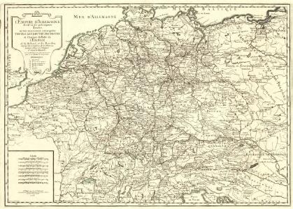
L'Empire d'Allemagne
1 : 2600000 Mollova mapová sbírka Jaillot, Alexis-Hubert Desbruslins, F. Jaillot, Alexis Hubert
Germany.
from Carey's general atlas, improved and enlarged : being a collection of maps of the world and quarters, their principal empires, kingdoms, &c.
Tabula Europae IIII. [Karte], in: Geographia universalis vetus et nova complectens Claudii Ptolemaei Alexandrini enarrationis libros VIII, S. 231.
1 Karte aus Atlas Münster, Sebastian [und Ptolemaeus, Claudius]
Tabula Europae IIII. [Karte], in: Claud. Ptolemaeus. Geographia lat. cum mappis [...], S. 263.
1 Karte aus Atlas Münster, Sebastian [und Ptolemaeus, Claudius]
L'Allemagne
1 : 2500000 L'Isle, Guillaume de Dezauche
Germania
1 : 2500000 Mollova mapová sbírka Delisle, Guillaume Seutter, Matthäus Wolff, Jeremias
L'Allemagne
1 : 2600000 Mollova mapová sbírka Delisle, Guillaume Liébaux, Jean-Baptiste L'Isle, Guillaume de
L'Allemagne
1 : 2500000 Mollova mapová sbírka Delisle, Guillaume Covens, Johannes I
Mappa Geographica exhibens Postas

GERMANIA
1 : 2500000 Evropa střední Delisle, Guillaume Lotter, Georg F. Tobiae Conradi Lotter
Germania
1 : 2500000 Evropa střední Delisle, Guillaume Lotter, Georg F. T. C. Lotter
Germania
1 : 2500000 Evropa střední Delisle, Guillaume Brahe, Tycho Tobiae Conradi Lotter
Germania
1 : 2500000 Evropa střední Delisle, Guillaume Brahe, Tycho in officina Tobiae Conradi Lotter
Germania
1 : 2500000 Evropa střední Delisle, Guillaume Brahe, Tycho in officina Tobiae Conradi Lotter
Germania
1 : 2500000 Evropa střední Delisle, Guillaume Brahe, Tycho in officina Tobiae Conradi Lotter
Germania
1 : 2500000 Německo Delisle, Guillaume Lotter, Georg F. T. C. Lotter
Sprachkarte von Deutschland
1 : 3000000 Evropa střední Bernhardt, Karl Bohné, J. J. von J.J. Bohné
Politisch-statistische Charte von Deutschland nebst dem grössten Theile von Pohlen, einem grossen Theile von Frankreich und Nord-Italien
1 : 2900000 Evropa střední Champion, J. N. Baumann, J. Mitzky & Comp.
Germany.
from A new systeme of the mathematicks: containing I. Arithmetick, as well natural and decimal, as in species, or the principles of algebra. II. Practical geometry, together with the first six books of Euclid's Elements, as also the eleventh and twelfth, symbo
Post- und Eisenbahnkarte von Deutschland und den benachbarten Laendern
1 : 2450000 Evropa střední Weiland, Karl Ferdinand Mädel, C. J. Geograph. Institut
Post- und Reise-Karte von Deutschland und den anliegenden Laendern bis London, Havre de Grace, Tours, Lyon, Genua, Bologna, Pest, Warschau, Königsberg u. jenseits Kopenhagen, nebst den Haupt-Routen durch das übrige Europa
1 : 1490000 Belgie Diez, F. M. Perthes, Justus Justus Perthes
Post- und Reise-Karte von Deutschland und den anliegenden Ländern bis London, Havre de Grace, Tours, Lyon, Genua, Bologna, Pest, Warschau, Königsberg u. jenseits Kopenhagen, nebst den haupt Routen durch das übrige Europa
1 : 1490000 Belgie Diez, F. M. Justus Perthes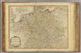
Germany.
1 : 2400000 Robert Laurie & James Whittle
Imperium Romano-Germanicum
1 : 2600000 Mollova mapová sbírka Seutter, Matthäus Seutter, Matthäus
Post- und Reisekarte von Deutschland, den Niederlanden, Belgien und der Schweiz
1 : 2470000 Belgie Bachmann, Friedrich Nast Friedr. Kornschen Buchhandlung
Post- und Reisekarte von Deutschland, den Niederlanden, Belgien und der Schweiz
1 : 2470000 Belgie Bachmann, Friedrich Nast Friedr. Kornschen Buchhandlung
Imperium Romano-Germanicum
1 : 2600000 Mollova mapová sbírka Seutter, Matthäus Seutter, Matthäus
Říše německá
1 : 1250000 Evropa střední Machát, František V. Neubert
Říše německá
1 : 1250000 Německo Machát, František V. Neubert