Maps of Sarreguemines

Carte Particuliere de Pays qui sont situéz entre le Rhein, la Saare, la Moselle, et la Basse Alsace
1 : 150000 Mollova mapová sbírka Jaillot, Alexis-Hubert Jaillot, Alexis Hubert
Partie Meridionale Des Pays Qui Sont Situéz Entre Le Rhein, La Saare, La Moselle Et La Basse Alsace
1 : 150000 Mollova mapová sbírka Mortier, Pieter Covens, Johannes I
Partie Meridionale Des Pays Qui Sont Situéz Entre Le Rhein, La Saare, La Moselle, Et La Basse Alsace. [Karte], in: Atlas nouveau, contenant toutes les parties du monde [...], Bd. 1, S. 241.
1 Karte aus Atlas Sanson, Nicolas Jaillot, Alexis Hubert und Mortier, Pieter
Mediomatrici
1 Karte : Kupferdruck ; 43 x 50 cm Sanson chez l'auteur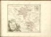

Le Theatre de la Guerre Sur le Haut Rhein
1 : 142000 Mollova mapová sbírka Sanson, Guillaume
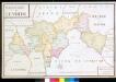
Le Flambeau de la Guerre Allumee au Rhin
Mollova mapová sbírka Delisle, Guillaume Schenk, Peter II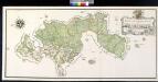
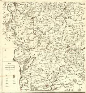
Delineatio Geometrica Über Das Hochfürstlich Hessen Hanau Lichtenbergische Amt Lemberg
Bailliage De Lemberg

Amt Lemberg

Le Flambeau de la Guerre Allumee au Rhin
Mollova mapová sbírka Delisle, Guillaume Schenk, Peter II
Geometrische Karte über das OberAmt Zweybrücken nebst dem dazu gehoerigen Amte Homburg
Bechstatt, I. C.
Le Flambeau de la Guerre Allumee au Rhin
Mollova mapová sbírka Delisle, Guillaume Schenk, Peter II
Treffen bey Pirmasens den 14. Sept. 1793, worinn der Regierende Herr Herzog von Braunschweig über den Französischen General Moreau einen wichtigen Sieg erfochten hat

Meßtischblatt 3597 : Pfaffenhofen, 1885
1 : 250000 Pfaffenhofen. - Aufn. 1883. - 1:25000. - [Berlin]: Reichsamt für Landesaufnahme, 1885. - 1 Kt.
Meßtischblatt 3596 : Buchsweiler, 1885
1 : 250000 Buchsweiler. - Aufn. 1883. - 1:25000. - [Berlin]: Reichsamt für Landesaufnahme, 1885. - 1 Kt.
Meßtischblatt 3592 : Duß, 1917
1 : 250000 Duß. - Aufn. 1881, hrsg. 1883, Aufldr. 1917. - 1:25000. - [Berlin]: Reichsamt für Landesaufnahme, 1917. - 1 Kt.
Meßtischblatt 3584 : Niederbronn, 1885
1 : 250000 Niederbronn. - Aufn. 1883. - 1:25000. - [Berlin]: Reichsamt für Landesaufnahme, 1885. - 1 Kt.
Meßtischblatt 3583 : Saareinsberg, 1914
1 : 250000 Saareinsberg. - Aufn. 1883, hrsg. 1885, Auflagendr. 1914. - 1:25000. - [Berlin]: Königl. Preuss. Landesaufnahme, 1914. - 1 Kt.
Meßtischblatt 3581 : Saar- Buckenheim, 1917
1 : 250000 Saar- Buckenheim. - Aufnahme 1882, hrsg. 1883, Auflagendr. 1917. - 1:25000. - [Berlin]: Königl. Preuss. Landesaufnahme, 1917. - 1 Kt.
Meßtischblatt 3580 : Insmingen, 1916
1 : 250000 Insmingen. - Aufn. 1882, hrsg. 1883, Aufldr. 1916. - 1:25000. - [Berlin]: Reichsamt für Landesaufnahme, 1916. - 1 Kt.
Meßtischblatt 3579 : Gr. Tänchen, 1914
1 : 250000 Gr. Tänchen. - Aufn. 1881, hrsg. 1883, Aufldr. 1914. - 1:25000. - [Berlin]: Reichsamt für Landesaufnahme, 1914. - 1 Kt.
Meßtischblatt 3571 : Stürzelbronn, 1883
1 : 250000 Stürzelbronn. - Aufn. 1882. - 1:25000. - [Berlin]: Reichsamt für Landesaufnahme, 1883. - 1 Kt.
Meßtischblatt 3570 : Bitsch, 1883
1 : 250000 Bitsch. - Aufn. 1882. - 1:25000. - [Berlin]: Reichsamt für Landesaufnahme, 1883. - 1 Kt.
Meßtischblatt 6909 : Rohrbach b. Bitsch, 1942
1 : 250000 Rohrbach b. Bitsch. - Hrsg. 1883, Ausg. 1942 - 1:25000. - [Berlin]: Preußische Landesaufnahme, Hauptvermessungsabt. XI, 1942. - 1 Kt.
Meßtischblatt 6811 : Pirmasens-Süd, 1943
1 : 250000 Pirmasens-Süd. - Aufn. 1911, hrsg. 1914, bericht./letzte Nachtr. - 1:25000. - Wiesbaden: Hauptvermessungsabteilung XI, 1943. - 1 Kt.
Meßtischblatt 6810 : Hornbach, 1942
1 : 250000 Hornbach. - Aufn. 1882/1911, hrsg. 1889/1914, bericht. 1939,. - 1:25000. - [Berlin]: Reichsamt für Landesaufnahme, 1942. - 1 Kt.
Meßtischblatt 3558 : Bliesbrücken, 1883
1 : 250000 Bliesbrücken. - Aufn. 1881. - 1:25000. - [Berlin]: Reichsamt für Landesaufnahme, 1883. - 1 Kt.
Meßtischblatt 6808 : Saargemünd, 1940
1 : 250000 Saargemünd. - Aufn. 1881, 1912, 1933/35, hrsg. 1883, bericht. - 1:25000. - [Berlin]: Reichsamt für Landesaufnahme, 1940. - 1 Kt.