Maps of Landkreis Mayen-Koblenz
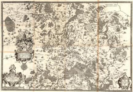
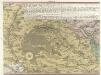
Dioecesis Trevirensis Tractvs Mosellanvs Inferior
1 : 50000 Mollova mapová sbírka Person, Nikolaus Person, Nicolas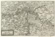
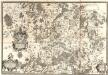
Mosella et Rheni Confluxus
Mollova mapová sbírka Person, Nikolaus Person, Nicolas
179 Simmern, uit: Topographische Special-Karte von Deutschland (von Central-Europa) / begründet von D.G. Reymann ; [entworfen und gezeichn. von Heinrich Berghaus... [et al.]]
1 : 200000 Annotatie: Lit.: Daniel Gottlob Reymann und die "Topographische Special-Karte von Deutschland" / von Wolfgang Scharfe, in: Kartographische Nachrichten, 39 (1989), Heft I, p. 1-10; Handgeschreven titel: Reymann's Deutschland : 24 Sectionen: Jena, Penig, Dresden, Zittau, Hirschberg, Breslau, Brieg, Andernach, Coblenz, Giessen, Fulda, Schleusingen, Plauen, Zwickau, Teplitz, Jung Bunzlau, Hohenelbe, Glatz, Neisse, Simmern, Prag, Luxemburg, Birkenfeld; Aanwezig: 23 bladen Reymann, Daniel Gottlob; Berghaus, Heinrich [Berlin : 2. Departement des Kriegsministeriums, Bureau für Plan- und Kartenzeichnung]
Le Flambeau de la Guerre Allumee au Rhin
Mollova mapová sbírka Delisle, Guillaume Schenk, Peter II
Carte des environs du Laacher-See
1 : 200000 Tardieu, Pierre François
Situation von der Vestung Rheinfels
Hill, Johann Jakob
Le Flambeau de la Guerre Allumee au Rhin
Mollova mapová sbírka Delisle, Guillaume Schenk, Peter II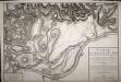
Carte de la Bataille de Neu Wied entre une Partie de l'Armée Française de Sambre et Meuse Commandée parl le Général en chef Hoch et le Corps Autrichiens commandé par le Général Krai
Ein Theil des Hundsrucks mit den angraenzenden Maynz u. Trierischen Laendern :
1 : 95000 Mollova mapová sbírka Homann, Johann Baptist Homann, Johann Baptista - dědici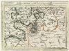
Montroyal Sambt der Gegend auff 2 Stund.
1 : 150000 Mollova mapová sbírka Bodenehr, Gabriel Bodenehr, Gabriel
Lager für ein Infanterie Regiment (29tes Landwehr Regiment) während der Herbstübungen des 8 Armee Corps im Jahr 1830 bei Coblenz
1 : 1100 Koblenz (Německo)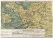
Ein Theil des Hundsrucks mit den angraenzenden Maynz u. Trierischen Laendern :
1 : 95000 Mollova mapová sbírka Homann, Johann Baptist Homann, Johann Baptista - dědici
Meßtischblatt 3434 : Simmern, 1925
1 : 250000 Simmern. - [Aufn. 1905], b[ericht. 19]16, N[achtr. 19]25. - 1:25000. - [Berlin]: Reichsamt für Landesaufnahme, [19]25. - 1 Kt.
Meßtischblatt 3434 : Simmern, 1920
1 : 250000 Simmern. - Aufn. 1905, hrsg. 1907, bericht. 1916, Aufl.-Dr. 1920. - 1:25000. - [Berlin]: Preuss. Landesaufnahme, 1920. - 1 Kt.
Meßtischblatt 3434 : Simmern, 1916
1 : 250000 Simmern. - Aufn. 1905, hrsg. 1907, bericht. 1916. - 1:25000. - [Berlin]: Preuss. Landesaufnahme, 1916. - 1 Kt.
Meßtischblatt 6010 : Kirchberg (Hunsrück), 1943
1 : 250000 Kirchberg (Hunsrück). - Aufn. 1905, hrsg. 1907, bericht. 1936, letzte Nachtr. 1940. - 1:25000. - [Berlin]: Reichsamt für Landesaufnahme, 1943. - 1 Kt.
Meßtischblatt 3432 : Sohren, 1914
1 : 250000 Sohren. - Hrsg. 1886, N[achtr. 19]14. - 1:25000. - [Berlin]: Preuss. Landesaufnahme, 1914. - 1 Kt.
Meßtischblatt 3432 : Sohren, 1909
1 : 250000 Sohren. - Aufn. 1885, hrsg. 1886, bericht. 1909. - 1:25000. - [Berlin]: Kgl. Preuss. Landesaufnahme, 1909. - 1 Kt.
Meßtischblatt 3432 : Sohren, 1886
1 : 250000 Sohren. - Aufn. 1885, hrsg. 1886. - 1:25000. - [Berlin]: Kgl. Preuss. Landesaufnahme, 1886. - 1 Kt.
Meßtischblatt 3431 : Bernkastel, 1914
1 : 250000 Bernkastel. - Aufn. 1885, hrsg. 1887, gedr. [19]14. - 1:25000. - [Berlin]: Kgl. Preuß. Landesaufnahme, 1914. - 1 Kt.
Meßtischblatt 3431 : Bernkastel, 1914
1 : 250000 Bernkastel. - Aufn. 1885, hrsg. 1887, gedr. [19]14. - 1:25000. - [Berlin]: Preuß. Landesaufnahme, 1914. - 1 Kt.
Meßtischblatt 3403 : Kisselbach, 1903
1 : 250000 Kisselbach. - Aufn. 1901. - 1:25000. - [Berlin]: Kgl. Preuss. Landesaufnahme, 1903. - 1 Kt.
Meßtischblatt 3402 : Kastellaun, 1903
1 : 250000 Kastellaun. - Aufn. 1901. - 1:25000. - [Berlin]: Kgl. Preuss. Landesaufnahme, 1903. - 1 Kt.
Meßtischblatt 3401 : Zell, 1888
1 : 250000 Zell. - Aufn. 1886. - 1:25000. - [Berlin]: Kgl. Preuss. Landesaufnahme, 1888. - 1 Kt.
Meßtischblatt 3400 : Alf, 1888
1 : 250000 Alf. - Aufn. 1886. - 1:25000. - [Berlin]: Kgl. Preuss. Landesaufnahme, 1888. - 1 Kt.
Meßtischblatt 5811 : Kestert, 1947
1 : 250000 Kestert. - Aufn. 1901, hrsg. 1903, bericht. 1935, letzte Na. - 1:25000. - Bad Godesberg: HVA, 1947. - 1 Kt.
Meßtischblatt 3364 : Dommershausen, 1903
1 : 250000 Dommershausen. - Aufn. 1901. - 1:25000. - [Berlin]: Kgl. Preuss. Landesaufnahme, 1903. - 1 Kt.
Meßtischblatt 3363 : Treis, 1888
1 : 250000 Treis. - Aufn. 1886. - 1:25000. - [Berlin]: Kgl. Preuss. Landesaufnahme, 1888. - 1 Kt.
Meßtischblatt 3362 : Cochem, 1887
1 : 250000 Cochem. - Aufn. 1886. - 1:25000. - [Berlin]: Kgl. Preuss. Landesaufnahme, 1887. - 1 Kt.
Meßtischblatt 3320 : Boppard, 1902
1 : 250000 Boppard. - Aufn. 1900, hrsg. 1902. - 1:25000. - [Berlin]: Kgl. Preuss. Landesaufnahme, 1902. - 1 Kt.