Maps of Kreis Euskirchen

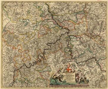
Archiepiscopatus et Electoratus Trevirensis Novissima delineatio
1 : 310000 Mollova mapová sbírka Wit, Frederik de Wit, Frederick
Archiepiscopatus ac electoratus Trevirensis et Eyfalia tractus novissima et accuratissima tabula
1 : 320000 1 Karte : Kupferdruck ; 48 x 54 cm Danckerts, Theodorus [Danckerts]
Parties des Archeveschés et Eslectorats de Mayence, de Treves, du Palatinat et Eslectorat du Rhein &
1 : 230000 Mollova mapová sbírka Jaillot, Alexis-Hubert Jaillot, Alexis Hubert
MOSELLAE FLUMINIS TABULA SPECIALIS
Eifel (Německo) Homann, Johann Baptist sumtibus Ioh. Baptistae Homanni
Mosellae fluminis tabula specialis
Eifel (Německo) Homann, Johann Baptist sumtibus Ioh. Baptistae Homanni
Mosellae fluminis tabula specialis
Eifel (Německo) Homann, Johann Baptist sumtibus Ioh. Baptistae Homanni
Mosellae fluminis tabula specialis
1 : 312000 Eifel (Německo) Homann, Johann Baptist sumtibus Ioh. Baptistae Homanni
Archiepiscopatus ac Electoratus Trevirensis ditio
1 : 310000 Mollova mapová sbírka Visscher, Nicolaes Gouwen, Giliam van der Schenk, Peter II
Trevirensis Archi-Episcopatus et Electoratus
1 : 310000 Mollova mapová sbírka Seutter, Matthäus Seutter, Matthäus
Mosellae Fluminis Tabula Specialis
1 : 310000 Mollova mapová sbírka Homann, Johann Baptist Homann, Johann Baptista - dědici

Treverensis Regio Archiepiscopatus Electoratusque Titulô insignus
1 : 300000 Mollova mapová sbírka Valk, Gerhard Valck, Gerard

Archiepiscopatus Trevirensis Recentißima Delineatio
1 : 270000 Mollova mapová sbírka Ram, Johannes de Ottens, Josua
Archiepiscopatus Trevirensis Recentißima Delineatio
1 : 270000 Mollova mapová sbírka Ram, Johannes de
Mosellae fluminis tabula specialis
1 : 308300 Eifel-oblast (Německo) Homann, Johann Baptist sumtibus Ioh. Baptistae Homanni
Mosellæ fluminis tabula specialis
1 Karte : Kupferdruck ; 47 x 56 cm Homann Johann Baptist Homann
Mosellæ fluminis tabula specialis
1 Karte : Kupferdruck ; 47 x 56 cm Homann Johann Baptist Homann
Mosellae Fluminis Tabula Specialis
1 : 300000 Mollova mapová sbírka Homann, Johann Baptist Homann, Johann Baptista - dědici
Höhenschichten-Karte der Eifel / von H. Rauff ; gezeichn. von W. Rose
1 : 200000 Annotatie geografische gegevens: Gebaseerd op: Topografische Uebersichtskarte des Deutschen Reiches Hermann Rauff; W. Rose fl. 1900 Bonn : Cohen
Département de Rhin et Moselle
1 : 270000 Mosela, řeka-oblast Chanlaire, P. G. chez P.G. Chanlaire

Archiepiscopatvs Trevirensis
1 : 370000 Mollova mapová sbírka Blaeu, Willem Janszoon Blaeu, Cornelis
Archiepiscopatvs Trevirensis
1 : 370000 Mollova mapová sbírka Janssonius, Johannes Janssonius, Johannes I
Theatre De La Guerre Dans Les Pays Qui Sont Situéz Entre le Rhin, la Saare, la Moselle et la Basse Alsace. [Karte], in: Atlas nouveau, contenant toutes les parties du monde [...], Bd. 1, S. 235.
1 Karte aus Atlas Sanson, Nicolas Jaillot, Alexis Hubert und Mortier, Pieter
[Kaart], uit: Kleines Relief-Panorama des Rheines
titelvariant: Kleines farbiges Relief-Panorama des Rheines; Annotatie: Titel op omslag: Kleines farbiges Relief-Panorama des Rheines; Met ill. van bezienswaardigheden aan weerszijden van de kaart Köln am Rhein : Hoursch & Bechstedt
Prüm 98, uit: Special-Karte von Mittel-Europa / nach amtlichen Quellen bearbeitet von W. Liebenow
1 : 300000 titelvariant: W. Liebenow's Mittel-Europa; Annotatie: Titel boven de bladen: W. Liebenow's Mittel-Europa Johannes Wilhelm Liebenow 1822-1897 Frankfurt a. M. : Ludwig Ravenstein
Prüm 98, uit: [W. Liebenow's Special-Karte von Mittel-Europa]
1 : 300000 titelvariant: W. Liebenow's Mittel-Europa; Annotatie: Titel boven de bladen: W. Liebenow's Mittel-Europa Johannes Wilhelm Liebenow 1822-1897 Hannover : Hermann Oppermann
Theatre de la Guerre sus la Mosella, avec le choc., qui se donna entre les deux Armées le 20. Octobre 1735
Mollova mapová sbírka
Carte topographique tres exacté de la Wetteravie
1 : 220000 Hesensko (Německo) Coentgen, Heinrich Hugo chez I.W.A. Iaeger