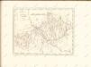
Maps of Meurthe-et-Moselle

Partie du Duché de Luxembourg et de l'Electorat de Treves
1 : 120000 Mollova mapová sbírka Baillieul, Gaspard Baillieul, Gaspard


Les Courans des Riviers de Meuse de Mozel et de la Sar ou se trouvent le Luxembourg et l'Archeveché de Treves
1 : 430000 Mollova mapová sbírka Nolin, Jean-Baptiste Nolin, Jean Baptiste II.
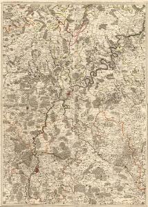
Le duché de Luxembourg divisé en quartier Wallon et Allemand
1 : 170000 Lucembursko (Belgie) Jaillot, Alexis-Hubert Hubert Iaillot

Ducatus Lutzenburgi novissima et accuratissima delineatio
1 : 400000 per Nicolaum Visscher [Amsterdam] : Nicolaes Visscher
Lvtzenbvrg Dvcatvs
1 : 500000 Mollova mapová sbírka Blaeu, Willem Janszoon Blaeu, Joan I.
Lvtzenbvrg Dvcatvs
1 : 750000 Mollova mapová sbírka Merian, Caspar Merian, Caspar
Ducatus Luxemburgi
1 : 326000 Lucembursko Homann, Johann Baptist a Ioh. Bapt. Homanno
DUCATUS LUXEMBURGI
1 : 320000 Lucembursko Homann, Johann Baptist a Ioh. Bapt. Homanno
Ducatus Luxemburgi
1 : 326000 Lucembursko Homann, Johann Baptist J.B. Homann
Carte nouvelle du duché de Luxembourg = Nova Luxemburgensis Ducatus tabula
par R. & I. Ottens Amsterdam : R. & I. Ottens
DUCATUS LUTZENBURGI Novissima et accuratissima DELINEATIO
1 : 370000 Belgie Visscher, Nicolaus per Nicolaum Visscher
Sheet 1, uit: Stanford's large scale map of the seat of war / Stanford's Geographical Estab[lishmen]t
1 : 300000 Stanford's Geographical Establishment, Londen London : Stanford
Ducatus Lutzenburgici tabula
1 : 320000 Lucembursko Wit, Frederick de per Fredericum de Wit
Ducatus Luceburgii, divisus in Regionem Germanicam et Wallonicam, porro etiam in Ducatum Bulonium, Comitatus Salmiae, et Viandae, Praeposituras Luceburgii, Arluni, et Bastonaci, et Toparchias Eschiae, Miremundae, et Orchemundae
1 : 300000 accuratissime expresserunt et in lucem ediderunt Gerardus et Leonardus Valk Amsterdam : Gerardus et Leonardus Valk
Ducatus Luxemburg distinctis limitibus majorum et minorum ditiorum
1 : 330000 Lucemburk (Lucembursko) Seutter, Matthäus a Matthaeo Seutter

Le Duché de Luxembourg
1 : 330000 Mollova mapová sbírka Fer, Nicolas de Starckman, P. Fer, Nicolas de
Ducatus Luceburgii
1 : 290000 Mollova mapová sbírka Valk, Gerhard Valck, Gerard
Le duché de Luxembourg
1 : 370000 Lucembursko Fer, Nicolas de Starckman, P. N. de Fer
Dvcatvs Lvtzenbvrgensis Nova et accurata descriptio
1 : 430000 Mollova mapová sbírka Schenk, Pieter Schenk, Peter I
Carte de la France, no. 2
1 Blatt : 61 x 83 cm s.n.
Luxenbvrgicvs ducatus
Mollova mapová sbírka Mercator, Gerhard Mercator, Gerard
Delineatio Topographica Altissimae Atque Adeò Verae Scaturiginis Danubii Fl: Ubi monendum, tenuissimos illos ramusculos aquae à rusticis, pro irrigandis pratis ita esse excavatos; et, si hoc non foret, aquam, sine dubio, alveolo uno, aut saltem paucioribus defluxuram fuisse
1 : 6000 Mollova mapová sbírka Marsili, Luigi Ferdinando
[25], uit: Hydro-Oro und Chorographische General Karte des Koenigreichs der Niederlande und der angrenzenden Länder bis Paris : mit der Angabe der Kunst und Heer-Strassen und der Entfernung der Poststationen / ... zusammengetragen und reducirt von ... Wilhelm Müller
1 : 400000 titelvariant: Generalkarte des Koenigreichs Hannover; Annotatie: 1e supplement bij: Generalkarte des Koenigreichs Hannover (1818) Müller, Wilhelm (fl. 1818) [Hannover : Wilhelm Müller]
Ducatus Luxemburg
1 : 316000 Mollova mapová sbírka Seutter, Matthäus Seutter, Matthäus Seutter, Matthäus
Ducatus Luxemburgi
1 : 316000 Mollova mapová sbírka Homann, Johann Baptist Homann, Johann Baptista