Maps of Mecklenburgische Seenplatte

Nieuwe Afteekening van het Eyland Rugen en de Straalsond als mede de Stad Straalsond ent Nieuwe diep met alle desselfs Gelegentheden Int Groot
1 : 170000 Mollova mapová sbírka Keulen, Gerard van Keulen, Gerard van
Eine Accurate Karte Von Pomeren, Wie Auch Dem Landt Rügen, Neben Strahlsundt In Form Seiner Belägerg. : Auch Die Tieffen Des Wasser Mit Sampt Den Grunden
1 : 250000 Mollova mapová sbírka Himmerich, Johann Schenk, Pieter Schenk, Peter II
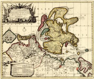
Insulae Et Principatus Rugiae cum vicinis Pomeraniae Littoribus Nova Tabula
1 : 210000 Mollova mapová sbírka Homann, Johann Baptista - dědici
Eigentliche Abbildung der Pomerischen Insul Rügen : Auf welcher die Dänen und Allűrte, von den Schweden auß Stralsund unversehens überfallen, eine gäntzliche Niederlag erlitten, und dadurch die ganze Insul den Schweden wieder raumen müssen. Geschehen Dienstag den 8. 18. Januarÿ Anno 1678
1 : 185000 Mollova mapová sbírka

Anklam 35, uit: Special-Karte von Mittel-Europa / nach amtlichen Quellen bearbeitet von W. Liebenow
1 : 300000 titelvariant: W. Liebenow's Mittel-Europa; Annotatie: Titel boven de bladen: W. Liebenow's Mittel-Europa Johannes Wilhelm Liebenow 1822-1897 Frankfurt a. M. : Ludwig Ravenstein
Theatrum belli in Pomerania citeriori
1 : 225000 Mollova mapová sbírka
Mappa Ducatus Megalopolitani Nova :
1 : 190000 Mollova mapová sbírka
Mappa Ducatus Megalopolitani Nova :
1 : 190000 Mollova mapová sbírka

Theatrum belli in Pomerania citeriore
1 : 220000 Mollova mapová sbírka Berger
60. Neustrelitz, uit: Topographische Uebersichtskarte des Deutschen Reiches / herausgegeben v. d. Kartogr. Abt. d. Königl. Preuß. Landesaufnahme
1 : 200000 titelvariant: Topogr. Übersichtskarte des Deutschen Reiches; Annotatie: Titel boven bladen ook: Topogr. Übersichtskarte des Deutschen Reiches; Annotatie geografische gegevens: Op elk blad twee maatstokken: 10 Kilometer = 5,5 cm; 1 geogr. Meile = 3,6 cm; Legenda onder op elk blad Königlich Preußische Landesaufnahme. Kartographische Abtheilung [S.l : Königlich Preußische Landesaufnahme, Kartographische Abtheilung]
43. Neubrandenburg, uit: Topographische Uebersichtskarte des Deutschen Reiches / herausgegeben v. d. Kartogr. Abt. d. Königl. Preuß. Landesaufnahme
1 : 200000 titelvariant: Topogr. Übersichtskarte des Deutschen Reiches; Annotatie: Titel boven bladen ook: Topogr. Übersichtskarte des Deutschen Reiches; Annotatie geografische gegevens: Op elk blad twee maatstokken: 10 Kilometer = 5,5 cm; 1 geogr. Meile = 3,6 cm; Legenda onder op elk blad Königlich Preußische Landesaufnahme. Kartographische Abtheilung [S.l : Königlich Preußische Landesaufnahme, Kartographische Abtheilung]
Rugia Insula Ac Ducatus
1 : 240000 Mollova mapová sbírka Lubin, Eilhard Covens, Johannes I
Rugia Insula Ac Ducatus
1 : 265000 Mollova mapová sbírka Lubin, Eilhard Schenk, Peter I
Rugia Insula Ac Ducatus
1 : 240000 Mollova mapová sbírka Lubin, Eilhard Blaeu, Joan I.
Rugia Insula Ac Ducatus
1 : 525000 Mollova mapová sbírka Merian, Matthäus Merian, Matthäus
Rugia Insula Ac Ducatus
1 : 265000 Mollova mapová sbírka Lubin, Eilhard Janssonius, Johannes I
Composite: 215. Rheinsberg. (Germany)
1 : 100000 Reichsamt fur Landesaufnahme
215. Rheinsberg. (Germany)
1 : 100000 Reichsamt fur Landesaufnahme
Composite: 119. Demmin. (Germany)
1 : 100000 Reichsamt fur Landesaufnahme
119. Demmin. (Germany)
1 : 100000 Reichsamt fur Landesaufnahme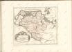

Composite: 152. Neubrandenburg. (Germany)
1 : 100000 Reichsamt fur Landesaufnahme
152. Neubrandenburg. (Germany)
1 : 100000 Reichsamt fur Landesaufnahme
Das Pommerische Kriegs Theatrum
1 : 200000 Mollova mapová sbírka Krügner, Johann Gottfried Boetius, Johann Theodor
Composite: 89. Greifswald. (Germany)
1 : 100000 Reichsamt fur Landesaufnahme
Composite: 184. Neu-Strelitz. (Germany)
1 : 100000 Reichsamt fur Landesaufnahme