Maps of West Pomeranian

Belgicarum XVII Provinciarum Tabula
1 : 875000 Mollova mapová sbírka Danckerts, Justus Danckerts, Justus
Le Duché de Pomeranie divisé en ses Principales Parties
1 : 550000 Mollova mapová sbírka Sanson, Guillaume Covens, Johannes I
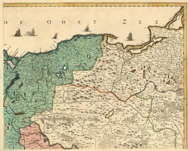
Le Duché de Pomeranie , compris sous le Cercle de la Haute Saxe, divisé suivant quil est presentement partagé entre la Couronne de Suede, et l'Eslecteur de Brandebourg ou sont Les Duchés de Pomeranie, de Stettin, de Wolgast, de Bardt, de Cassubie, et de Vandalie, la Principauté et Isle de Rugen, le Comté de Gutzkow, les Seigneuries de Louwenboch et de Butow
1 : 675000 Mollova mapová sbírka Sanson, Guillaume Jaillot, Alexis Hubert
Das Herzogthum Pommern, wie es theil der Cron Schweden, theils Chur-Brandenburg zugehörig
1 : 550000 Mollova mapová sbírka Sanson, Guillaume Hoffmann, Johann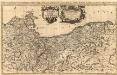
Le Duché de Pomeranie divisé en ses Principales Parties
1 : 550000 Mollova mapová sbírka Sanson, Guillaume Jaillot, Alexis Hubert
PALATINATVS | POSNANIENSIS, | IN MAIORI POLONIA PRIMARII
NOVA DELINEATIO | Per G.F.M. Gerard Coeck sculpsit. Amsterdami | Exc. Joannes Blaeu.
Palatinatus Posnaniensis. In Majori Polonia Primarii Nova Delinatio [Karte], in: Novus atlas absolutissimus, Bd. 1, S. 96.
1 Karte aus Atlas Janssonius Offizin
Die Preussische Provinz Posen, bestehend aus den Regierungs-Bezirken: Posen & Bromberg
1 : 1850000 Provinz Posen
Marchia Nova; Vulgò New Marck in March. Brandenburg. [Karte], in: Novus atlas absolutissimus, Bd. 2, S. 63.
1 Karte aus Atlas Janssonius Offizin
Posen.
1 : 945000 Flemming, Carl
Bromberg
1 : 600000 Opitz, Carl Solbrig
Posen.
1 : 810000 Radefeld, Carl Christian Franz, 1788-1874
Provinz Posen
1 : 1200000 Provinz Posen
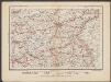
Kreise der Provinz Posen 1864
Preußen, Provinz Posen, Verwaltungsgliederung Kunz, Andreas ; Moeschl, Joachim Robert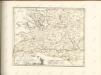

Provinz Posen
Grosser Hand-Atlas über alle Theile der Erde in 170 Karten Meyer, J. Verlag des Bibliographischen Instituts
Sect. 9: Stettin, uit: Geologische Karte des Deutschen Reichs in 27 Blaettern / [von] Richard Lepsius ; Red. von C. Vogel
1 : 500000 Annotatie: Blad 18 ontbreekt; Een aantal bladen op linnen; Een aantal bladen gereviseerd 1913-1914; Annotatie geografische gegevens: Met schaalstokken o.a. in kilometers; Legenda Carl Vogel 1828-1897 Gotha : Justus Perthes
Mapa Wojewodztwa Szczecinskiego
Posen
1 : 600000 Opitz, Carl Solbrig
Silesia Inferior. [Karte], in: Le théâtre du monde, ou, Nouvel atlas contenant les chartes et descriptions de tous les païs de la terre, Bd. 1, S. 210.
1 Karte aus Atlas Blaeu, Willem Janszoon und Blaeu, Joan Blaeu, Willem Janszoon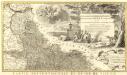
Novissimum Silesiae Theatrum
1 : 400800 Mollova mapová sbírka Condet, Johannes Covens, Johannes I
Sect. 15: Frankfurt a/O, uit: Geologische Karte des Deutschen Reichs in 27 Blaettern / [von] Richard Lepsius ; Red. von C. Vogel
1 : 500000 Annotatie: Blad 18 ontbreekt; Een aantal bladen op linnen; Een aantal bladen gereviseerd 1913-1914; Annotatie geografische gegevens: Met schaalstokken o.a. in kilometers; Legenda Carl Vogel 1828-1897 Gotha : Justus Perthes
Monumenta Cartographica Bohemiae II.: Müllerova mapa

MARCHIONATUS | BRANDENBURGICI | PARTES DUÆ, | NOVA MARCHIA | et | UCKERANA
Auctore | OLAO JOANNIS GOTHO | Gustaui Magni Cosmographo. [Amsterdam : Joan Blaeu]
March. Brandenburgici Pars, quae Marchia Media Vulgo Mittesmarck audit
1 : 400000 Mollova mapová sbírka Wit, Frederik de Covens, Johannes I
Marchia Media Vulgo Mittel Marck in March: Brandenb:
1 : 500000 Mollova mapová sbírka Valk, Gerhard Schenk, Peter I
Marchia Media Vulgo Mittel Marck in March: Brandenb:
1 : 510000 Mollova mapová sbírka Janssonius, Johannes Janssonius, Johannes I
Marchia nova Vulgo New Marck in March: Brandenburg
1 : 470000 Mollova mapová sbírka Schenk, Pieter Schenk, Peter I
Tempelburg 37, uit: Special-Karte von Mittel-Europa / nach amtlichen Quellen bearbeitet von W. Liebenow
1 : 300000 titelvariant: W. Liebenow's Mittel-Europa; Annotatie: Titel boven de bladen: W. Liebenow's Mittel-Europa Johannes Wilhelm Liebenow 1822-1897 Frankfurt a. M. : Ludwig Ravenstein