Maps of Belgrade
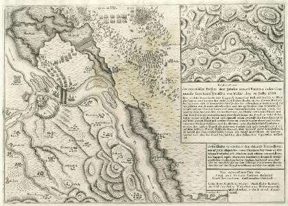
Gründliche Vorstellung der Schantz Perischan.
Mollova mapová sbírka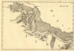
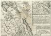
Palagis - Costalaz
Mollova mapová sbírka Marsili, Luigi Ferdinando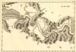
Costalaz - Jetz
Mollova mapová sbírka Marsili, Luigi Ferdinando
Die Feste Belgrad
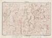
1 : 75000 Bělehrad (Srbsko : oblast)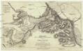
Ganz neuer und richtiger Situationsplan von Belgrad und den herumligenden Gegenden
Bělehrad-oblast (Srbsko) Pennier Weigel, Christoph Sebast. Hartl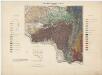
Zone 26, 27, Kol. XXV, Fehértemplom, Szászkabánya und Ómoldova, uit: [Geologische Specialkarte der im Reichsrathe vertretenen Königreiche und Länder der österreichisch-ungarischen Monarchie] / geologische Aufnahmen der königl. ung. Geologischen Anstalt
1 : 75000 Annotatie: Verantwoordelijkheidsvermelding in 1909 veranderd in: Königliche Ungarische Geologische Reichsanstalt; Sommige bladen in het Frans; Annotatie geografische gegevens: Coördinaten gebaseerd op nulmeridiaan van Ferro (Hierro) Königliche Ungarische Geologische Reichsanstalt; Königliche Ungarische Geologische Anstalt Budapest : [Königliche Ungarische Geologische Anstalt]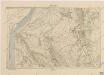
Železnik

Bavaniste und Jaszenova.
from Spezialkarte der osterreichisch-ungarischen Monarchie.
Weisskirchen und Szaszkabanya.
from Spezialkarte der osterreichisch-ungarischen Monarchie.
Zemun und Pancsova / Semlin
1 : 75000 Pančevo, Zemun Geripp: A. Rogić. Terrain: Oblt. E. Lanna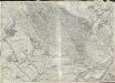
Bavaniste und Jaszenova
1 : 75000 Kovin Gemeindegebiet
Weisskirchen und Szászkabánya
1 : 75000 Bela Crkva, Sasca Montanǎ Geripp: Fwkr. Suchánek u. Gfrtr. Tuschell. Terrain: Lieut. Hentke u. Oberlt. Zothe
Semlin und Pancsova.; Spezialkarte der osterreichisch-ungarischen Monarchie.
from Spezialkarte der osterreichisch-ungarischen Monarchie. Austro-Hungarian Monarchy. Militärgeographisches Institut.,
Mehadia.; Spezialkarte der osterreichisch-ungarischen Monarchie.
from Spezialkarte der osterreichisch-ungarischen Monarchie. Austro-Hungarian Monarchy. Militärgeographisches Institut.,
Bozovics.; Spezialkarte der osterreichisch-ungarischen Monarchie.
from Spezialkarte der osterreichisch-ungarischen Monarchie. Austro-Hungarian Monarchy. Militärgeographisches Institut.,
Mehadia
1 : 75000 Mehadia Geripp: Assist. Scherling. Terrain: Feuerwkr. Kotrtsch
Bozovics
1 : 75000 Bozovici Geripp: Obejäger Dannerer. Terrain: Lieut. Tschofen
Kostolac Viminacivm
1 : 6500 Kostolac (Srbsko) Papáček, Pavel Florinskij, Timofej Dmitrijevič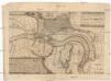
Plan wie die köm. [sic] kay. Armee ihren Marche und Passage über die Donau in das Lager vor Bellgrad genomen, auch wie unsere K. Schiff durch die Donaviz und Temes Bellgrad vorbey zur bedeckung unserer Schiff brucken sich postirt
Bělehrad-oblast (Srbsko) Biberger, Johann Ulrych
Belagerung der Stadt und Vestung Belgrad
Belgrad Türkenkrieg <1714-1718>, Schlacht von Belgrad <1717>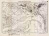
Lambert-Cholesky sheet 1748 (Socol)
1 : 20000 Romanian military topographic map sheet under Lambert-Cholensky projection Serviciul Geografic al Armatei geo-spatial.org Serviciul Geografic al Armatei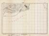
Lambert-Cholesky sheet 1747 (Klicevac)
1 : 20000 Romanian military topographic map sheet under Lambert-Cholensky projection Institutul Geografic al Armatei geo-spatial.org Institutul Geografic al Armatei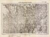
Lambert-Cholesky sheet 1848 (Neramezo)
1 : 20000 Romanian military topographic map sheet under Lambert-Cholensky projection Direcția Topografică Militară geo-spatial.org Direcția Topografică Militară
Lambert-Cholesky sheet 1847 (Vk. Gradiste)
1 : 20000 Romanian military topographic map sheet under Lambert-Cholensky projection Direcția Topografică Militară geo-spatial.org Direcția Topografică Militară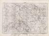
Lambert-Cholesky sheet 1948 (Stinapari)
1 : 20000 Romanian military topographic map sheet under Lambert-Cholensky projection Direcția Topografică Militară geo-spatial.org Direcția Topografică Militară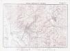
Lambert-Cholesky sheet 1947 (Moldova Veche)
1 : 20000 Romanian military topographic map sheet under Lambert-Cholensky projection Institutul Geografic Militar geo-spatial.org Institutul Geografic Militar
Lambert-Cholesky sheet 2048 (Şopotu Nou)
1 : 20000 Romanian military topographic map sheet under Lambert-Cholensky projection Direcția Topografică Militară geo-spatial.org Direcția Topografică Militară
Lambert-Cholesky sheet 2047 (Gârnic)
1 : 20000 Romanian military topographic map sheet under Lambert-Cholensky projection Direcția Topografică Militară geo-spatial.org Direcția Topografică Militară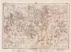
Lambert-Cholesky sheet 2148 (Bănia)
1 : 20000 Romanian military topographic map sheet under Lambert-Cholensky projection Direcția Topografică Militară geo-spatial.org Direcția Topografică Militară