Maps of Croatia

Illyricvm
1 : 1200000 Mollova mapová sbírka Sambucus, Joannes
Illyricum. Ioan. Sambucus Ortelio Suo, S. Mitto hanc quòque tabellam qua neceßaria confinia Pannoniae declarantur, fluviorum & aliquot locorum situs Hirschvogelij recte mutavi, Angelini autem studio plurima adieci, et intervalla correxi, ut parum quis si cum Hirschvogelij haec coniungat desideravit, si qui errores sint, dies certiora docebit
1 : 1200000 Illyrien, Dalmatien Sambucus, Johannes; Hirschvogel, Augustin
Illyricum. [Karte], in: Theatrum orbis terrarum, S. 255.
1 Karte aus Atlas Ortelius, Abraham
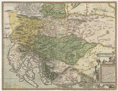
Sclavonia oder Windisch Marck, Bossen, Crabaten, etc. ; Sclauonia oder Windisch Marck, Bossen, Crabaten, ec.
1 : 330000 Krain, Steiermark Münster, Sebastian
Illyricum. [Karte], in: Theatrum orbis terrarum, S. 350.
1 Karte aus Atlas Ortelius, Abraham Vrients, Jan Baptista
Schlavoniae, Croatiae, Carniae, Istriae, Bosniae, Finitimarumque Regionum Nova Descriptio [Karte], in: Theatrum orbis terrarum, S. 97.
1 Karte aus Atlas Ortelius, Abraham
Schlavoniae, Croatie, Carniae, Istriae, Bosniae, Finitimarumque Regionum Nova Descriptio [Karte], in: Theatrum orbis terrarum, S. 258.
1 Karte aus Atlas Ortelius, Abraham
Schlavoniae, Croatiae, Carniae, Istriae, Bosniae, Finitimarumque Regionum Nova Descriptio
Südosteuropa Hirschvogel, Augustin
Fo. 2, uit: Carta geologica d'Italia
1 : 1000000 Rome : R. Ufficio Geologico
Carta d'Italia alla scala di 1 a 1 000 000
1 : 1000000 Nordost-Blatt Istituto Geografico Militare (Firenze) Istituto Geografico Militare
Strassen- und Eisenbahnkarte des oesterreichischen Kaiserthumes
1 : 864000 Blatt 10 Schaller, G. K.K. Militärisch-Geografisches Institut, Karten-Evidenthaltungs-Abteilung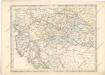
Strassen und Eisenbahnkarte des oesterreichischen Kaiserthumes

Eisenbahnkarte der k.u.k. oesterreichisch-ungarischen Monarchie
Sclauonia oder Windisch Marck, Bossen, Crabaten, ec
1 : 1200000 1 Karte : Holzschnitt ; 29 x 34 cm Münster, Sebastian [Sebastian Henricpetri]
Schlavoniae, Croatiae, Carniae, Istriae, Bosniae, finitimarvmqve regionvm nova descriptio / avctore
1 : 650000 1 Karte : Kupferdruck ; 31 x 46 cm Hirschvogel, Augustin [Verlag nicht ermittelbar]
Königreich Illyrien
1 : 1250000 Evropa jihovýchodní Mollo, Tranquillo Tranquillo Mollo
Königreich Illyrien
1 : 1233000 Ilýrie
Slavonien. Comitat Pozsega. Croatien: Comitate: Kövös, Varásd, Zágráb. Militär-Gränze. Regimenter: Likaner, Ottocháner, Oguliner, Szluiner, Köröser, Szent Györger und 2tes Báner und Gradiskaner Regiment
Ungarn Verkehrsweg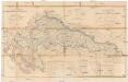
Zemljovid Hrvatske i Slavonije
1 : 504000 Bosna a Hercegovina Katzenschläger, Michael Jelačić, Josip Artaria
Carte internationale du monde au 1,000,000 E
1 : 1000000 Terst (Itálie) Istituto geografico militare

Strassen-Karte der Croatischen Militair-Grenze
1 : 430000 Chorvatsko K. k. Generalquartiermeisterstab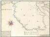
Vorstellung Deren von Triest umb das gantze Istrien Ligenden Merrhäfen oder gelegsamen örther denen nacher Triest und Fiume fährenden Schiffen infähl der Nots zu Sicherer einanckerung dienlichen büessen. Pickes Zeichen: bedeütet aller orthen den Port die difern aber das Wasser in Clafftern in die Tieffen
Mollova mapová sbírka Seiller, Johann Georg
Letecká mapa Evropy

Tabula Ducatus Carnioliae Vindorum Marchiae et Histriae ex mente Illustr.mi quondam L. B. Valvasorii concinnata et exhibita â Io. Bapt. Homanno S. C. M. Geogr.
Krain, Istrien Valvasor, Johann Weikhard <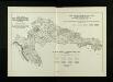
Pomor s tuberkuloze 1901.–1910. po upravnim kotarima i gradovima
Kroatien Slawonien Sterbeziffer Statistik Tuberkulose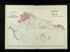
Vinogradi 1914. po upravnim kotarima i gradovima
Kroatien Slawonien Verbreitungskarte Statistik Weinbau
Descriptio Totius Lyridis XVI. No. Tab. [Karte], in: Claud. Ptolemaeus. Geographia lat. cum mappis [...], S. 404.
1 Karte aus Atlas Münster, Sebastian [und Ptolemaeus, Claudius]