Maps of District of Trnava
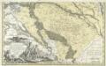
Comitatvs Posoniensis Germanis Presbvrg dicti Delineatio Geographica
1 : 150000 Mollova mapová sbírka Homann, Johann Baptist Alber, Johann Eberhard Homann, Johann Baptista - dědici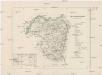
Ober-Neutraer Comitat
1 : 280000 Nitra-oblast (Slovensko)
C. Nitriensis. Tab. II
Slowakei Komitat Neutra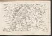
C. Posoniensis. Tab. I
Slowakei Komitat Preßburg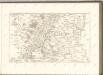

Malé Karpaty severná časť

Szencz und Pistyan (Ungarn).
from Spezialkarte der osterreichisch-ungarischen Monarchie.
Tyrnau.
from Spezialkarte der osterreichisch-ungarischen Monarchie.
III. vojenské mapování 4658/4
1 : 25000
Landshut, Sasvar und Hohenau.
from Spezialkarte der osterreichisch-ungarischen Monarchie.
Durnkrut und Bosing.
from Spezialkarte der osterreichisch-ungarischen Monarchie.
III. vojenské mapování 4659
1 : 75000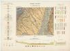
Zone 12, Kolonne XVII, Umgebung von Nagyszombat, uit: [Geologische Specialkarte der im Reichsrathe vertretenen Königreiche und Länder der österreichisch-ungarischen Monarchie] / geologische Aufnahmen der königl. ung. Geologischen Anstalt
1 : 75000 Annotatie: Verantwoordelijkheidsvermelding in 1909 veranderd in: Königliche Ungarische Geologische Reichsanstalt; Sommige bladen in het Frans; Annotatie geografische gegevens: Coördinaten gebaseerd op nulmeridiaan van Ferro (Hierro) Königliche Ungarische Geologische Reichsanstalt; Königliche Ungarische Geologische Anstalt Budapest : [Königliche Ungarische Geologische Anstalt]
Szenic und Pistyán
1 : 75000 Senica, Pistyan Geripp: Feldw. Rücker. Terrain: Lieut. Udalrik
Tyrnau
1 : 75000 Trnava, Umland Geripp: Assist. Scherling. Terrain: Offizial Pflügl
Trnava
1 : 75000 Slovensko Vojenský zeměpisný ústav
Trnava
1 : 75000 Slovensko Vojenský zeměpisný ústav
Tyrnau
1 : 75000 Slovensko Pflugl K. u. k. Militär-geographisches Institut
III. vojenské mapování 4559
1 : 75000
Piešťany
1 : 75000 Piešťany-oblast (Slovensko) Vojenský zeměpisný ústav
Piešťany
1 : 75000 Piešťany (Slovensko : oblast) Vojenský zeměpisný ústav
Piešťany
1 : 75000 Piešťany (Slovensko : oblast) Vojenský zeměpisný ústav
Lanžhot a Šaštín
1 : 75000 Lanžhot (Česko : oblast) Vojenský zeměpisný ústav
Lanžhot
1 : 75000 Lanžhot-oblast (Česko) Vojenský zeměpisný ústav
Lanžhot a Šaštín
1 : 75000 Lanžhot (Česko : oblast) Vojenský zeměpisný ústav
III. vojenské mapování 4558
1 : 75000
III. vojenské mapování 4558
1 : 75000
III. vojenské mapování 4658
1 : 75000
Landshut, Schlossberg und Hohenau
1 : 75000 Lanžhot, Hohenau an der March Schrift u. Gerippe v. Hptm. Schuberth. Terrainschraffirung v. R. Bloschitz


