Maps of Southern Transdanubia

Vermehrte und Verbesserte Landkarten des Königreichs Ungarn :
1 : 500000 Mollova mapová sbírka Stier, Martin Böner, Johann-Alexander Endter, Martin
Augustissimo Romanor. Imperatori Iosepho I. Hungaria Regi Invictissimo Mappam Hanc Regni Hungariae
1 : 540000 Mollova mapová sbírka Müller, Johann Christoph
Ducatus Stiriae novissima tabula
1 : 470000 Štýrsko (Rakousko) Homann, Johann Baptist Vischer, Georg Matthaeus a Ioh. Bapti. Homanno
Geographischer Entwurff des Herzogthums Steyermarck nach Der neuen Eintheilung in 5. Creÿse und der perpetuirl. Marche-Route
1 : 460000 Mollova mapová sbírka Diettel, Christoph
Ducatus Styriae Tabula
1 : 950000 Mollova mapová sbírka Engelbrecht, Christian Engelbrecht, Martin
Ducatus Styriae Tabula
1 : 950000 Mollova mapová sbírka Pfeffel, Johann Andreas
Stiria Ducatus juxta recentissimas observationes et accuratissimas mappas commoda hac forma aeri sculptus et usui publico destinatus
1 : 475000 Mollova mapová sbírka Seutter, Matthäus Seutter, Matthäus
Ducatûs Stiriae Novissima Tabula ex ampliore mappa olim R.Dmi. Georgii Matth. Vischer, S.C.M. Leopoldi I. Glor. Mem. Geographi deducta
1 : 470000 Mollova mapová sbírka Homann, Johann Baptist Homann, Johann Baptista
Stiria Vulgo Steyrmarck
1 : 433300 Mollova mapová sbírka Schenk, Peter I
Styria
1 : 416000 Mollova mapová sbírka Blaeu, Willem Janszoon Blaeu, Willem Jansz.
Stiria = Steyrmarck /
1 : 600000 Mollova mapová sbírka Merian, Matthäus Merian, Matthäus
Ducatus Stiriae Novissima Tabula
1 : 470000 Mollova mapová sbírka Vischer, Georg Matthaeus Homann, Johann Baptista - dědici
Stiria Steyrmarck. [Karte], in: Le théâtre du monde, ou, Nouvel atlas contenant les chartes et descriptions de tous les païs de la terre, Bd. 1, S. 242.
1 Karte aus Atlas Blaeu, Willem Janszoon und Blaeu, Joan Blaeu, Willem Janszoon
Stiria [Karte], in: Novus atlas absolutissimus, Bd. 2, S. 282.
1 Karte aus Atlas Janssonius Offizin
Stiria [Karte], in: Gerardi Mercatoris et I. Hondii Newer Atlas, oder, Grosses Weltbuch, Bd. 1, S. 349.
1 Karte aus Atlas Mercator, Gerhard und Hondius, Jodocus Jansson, Jan
Stiria Steyrmarck. [Karte], in: Theatrum orbis terrarum, sive, Atlas novus, Bd. 1, S. 130.
1 Karte aus Atlas Blaeu, Joan Blaeu, Willem Janszoon
Stiria [Karte], in: Gerardi Mercatoris Atlas, sive, Cosmographicae meditationes de fabrica mundi et fabricati figura, S. 475.
1 Karte aus Atlas Mercator, Gerhard Montanus, Petrus
Specialkarte zu den Manövern des 3. Corps 1891
1 : 75000 K.u.k militär-geographisches Institut
Generalkarte zu den Manövern des 3. Corps 1891
1 : 300000 Lublaň (Slovinsko : oblast)
Handkarte des Herzogthumes Steiermark
1 : 750000 Štýrsko (Rakousko) Schober, Karl k. u. k. milit.-geograph. Institut
STIRIA | Steyrmarck.
Apud Guiljelmum Blaeuw. | Amsterdami.
Zone 20, Col. XI, Eisenkappel und Kanker, uit: Geologische Karte der im Reichsrathe vertretenen Königreiche und Länder der Österreich-Ungarischen Monarchie : auf Grundlage der Specialkarte i.M. 1:75.000 des k.u.k. Militär-geographischen Institutes / neu bearb. und als Kartenwerk von 341 Blattnummern in zwanglosen Lfg. hrsg. durch die k.k. Geologische Reichsanstalt in Wien
1 : 75000 titelvariant: Geologische Spezialkarte der im Reichsrate vertretenen Königreiche und Länder der Österreichisch-Ungarischen Monarchie; Geologische Specialkarte der im Reichsrathe vertretenen Königreiche und Länder der Österreichisch-Ungarischen Monarchie; Annotatie: Titel bovenaan kaartblad: Geologische Spezialkarte der im Reichsrate vertretenen Königreiche und Länder der Österreichisch-Ungarischen Monarchie en Geologische Specialkarte der im Reichsrathe vertretenen Königreiche und Länder der Österreichisch-Ungarischen Monarchie; Annotatie geografische gegevens: Coördinaten gebaseerd op nulmeridiaan van Ferro (Hierro) Kaiserlich-Königliche Geologische Reichsanstalt, Wenen Wien : K.K. Geologische Reichsanstalt
Stiria Steyrmarck. [Karte], in: Novus Atlas, das ist, Weltbeschreibung, Bd. 1, S. 213.
1 Karte aus Atlas Blaeu, Joan Blaeu, Willem Janszoon

General-Karte des Herzogthums Steyermark
1 : 288000 Slovinsko
Charte von Innerösterreich oder den vereinigten Herzogthümern Steyermark und Kaernten
1 : 725000 Korutansko (Rakousko) im Kunst und Industrie Comptoir
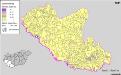
Kroaten in Südwest-Ungarn 1880
Transdanubien (Süd) Kroaten, Siedlung Bottlik, Zsolt
Stiria
1 Karte : Kupferdruck ; 29 x 40 cm Mercator; Hondius Henricus Hondius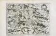
Stiria
1 Karte : Kupferdruck ; 29 x 40 cm Mercator s.n.