Maps of Primorje-Gorski Kotar County

Vermehrte und Verbesserte Landkarten des Königreichs Ungarn :
1 : 500000 Mollova mapová sbírka Stier, Martin Böner, Johann-Alexander Endter, Martin
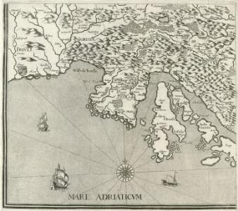
Vorstellung Deren von Triest umb das gantze Istrien Ligenden Merrhäfen oder gelegsamen örther denen nacher Triest und Fiume fährenden Schiffen infähl der Nots zu Sicherer einanckerung dienlichen büessen. Pickes Zeichen: bedeütet aller orthen den Port die difern aber das Wasser in Clafftern in die Tieffen
Mollova mapová sbírka Seiller, Johann Georg
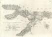
Croatia
Mollova mapová sbírka Hoffmann, Johannes Hoffmann, Johann
Augustissimo Romanor. Imperatori Iosepho I. Hungaria Regi Invictissimo Mappam Hanc Regni Hungariae
1 : 540000 Mollova mapová sbírka Müller, Johann Christoph
Mappa generalis regni Hungariae partiumque adnexarum Croatiae, Slavoniae...

[Slovinsko a Chorvatsko]
1 : 576000 Chorvatsko
Carta del litorale Austriaco
1 : 440000 Istrijský poloostrov (Slovinsko a Chorvatsko) Schwarzer, Ernesto de
Grenzgebiet von Zagrabiensis und Corbaviensis
1 : 1850000 Diözese Krbava, Diözese Zagreb, Grenze
Istrie
1 : 750000 Machát, František c. a k. voj. zeměpisný ústav
Oesterreichische Riviera
Accuratissima totius Savi area, in VI. Tabulis Geographicis repreasentata ab utraqve sua Origine usqve ad Illapsum in Danubium: nec non totius Labaci Fluvii una cum incurrentibus Fluminibus et adjacentibus Locis ac confiniis].
Mollova mapová sbírka Renner, F. C. Kaltschmidt, Abraham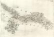
Pars Regni Croatiae
Mollova mapová sbírka Renner, F. C. Kaltschmidt, Abraham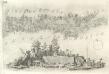
Pars Styriae Pars Regni [Ca]rnioliae Croatiae
Mollova mapová sbírka Renner, F. C. Kaltschmidt, Abraham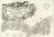
Ausführlicher Plan des gantzen Sau-Stroms, in VI. Tabellen vorgestellet, von seinen beyden Ursprüngen bis Zum Einfall in die Donau: wie auch des gantzen Laybaci-Flusses, sambt allen darein-fallengen Elüssen und daran liegenden Orthern, und Gränitzen.
Mollova mapová sbírka Renner, F. C. Kaltschmidt, Abraham
Karte der Kronländer Görz mit Gradisca und Istrien und der reichsunmittelbaren Stadt Triest mit deren politischen und gerichtlichen Eintheilung
Gorice a Gradiška Kettner, Vincenz
Goritiae, Karstii, Chaczeolae, Carniolae, Histriae, et Windorvm marchae descrip
1 Karte : Kupferdruck ; 31 x 23 cm Lazius; Ortelius s.n.
Goritiae, Karstii, Chaczeolae, Carniolae, Histriae, et Windorvm marchae descrip
1 Karte : Kupferdruck ; 31 x 23 cm Lazius; Ortelius s.n.
[Generalkarte von Bosnien und der Hercegovina]
1 : 300000 Bosnien-Herzegowina Bosnien
Generalkarte von Zentraleuropa

Generalkarte von Zentraleuropa
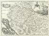
Regnum Croatiae
Mollova mapová sbírka Bruggen, Johann van der Brugge, Johannes van der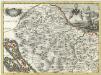
Regnum Croatiae
Mollova mapová sbírka Bruggen, Johann van der Brugge, Johannes van der
Partie de la Dalmatie du nord ouest
Dalmácie (Chorvatsko) im Verlage des Kunst und Industrie Comptoirs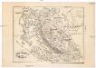
Ostrovy Quarnerské a Velebit
1 : 913000 Dalmácie (Chorvatsko)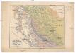
Ostrovy Quarnerské a Velebit
1 : 913000 Dalmácie (Chorvatsko)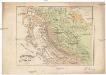
Ostrovy Quarnerské a Velebit
1 : 913000 Dalmácie (Chorvatsko)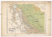
Ostrovy Quarnerské a Velebit
1 : 913000 Dalmácie (Chorvatsko)
Carta del litorale Austriaco
Istrijský poloostrov (Slovinsko a Chorvatsko) Schwarzer von Heldenstamm, Ernst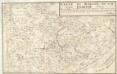
Carte Du Royaume De La Croatie
Mollova mapová sbírka