Maps of West
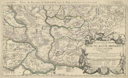
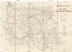
Le Royaume de Hongrie Diuise'en Haute, et Basse, Hongrie auec l'Esclavonie, Subdiuisees en leurs Comtez
1 : 1300000 Mollova mapová sbírka Coronelli, Vincenzo Maria Nolin, Jean Baptiste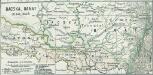
Bacska, Banat 1848, 1849
1 : 2775000 Banat, Batschka, Ungarn / Revolution <1848-1849>
Strassen- und Eisenbahnkarte des oesterreichischen Kaiserthumes
1 : 864000 Blatt 11 Schaller, G. K.K. Militärisch-Geografisches Institut, Karten-Evidenthaltungs-Abteilung
Letecká mapa Evropy
Strassen-Karte der Banatischen Militair-Grenze
1 : 432000 Banát
Strassen-Karte der banatischen Militair-Grenze
1 : 440000 Banát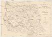
STRASSEN-KARTE der Banatischen MILITAR-GRENZE
1 : 440000 Banát
XIV, uit: General-Karte des oesterreichischen Kaiserstaates mit einem grossen Theile der angrenzenden Länder / durch Josef Scheda ... bearb. und hrsg
1 : 576000 Annotatie geografische gegevens: Maatstokken: oesterreichische Meilen, geografische oder deutsche Meilen, preussische Meilen, türkische Berri, französische Lieues, russische Werste; Maatstok per blad: wiener Klafter, öster. Meilen; Blad XIX: statistische en taalkundige informatie; Blad XIX: legenda [Wien : K.K. Militärisch-Geografisches Institut]
H.7. Orsova, uit: [Übersichtskarte von Europa 1:750.000]
1 : 750000 Wien : K.u.K. Militärgeographisches Institut
Die Kriegsschauplatz in Ungarn
1 : 864000 Evropa jihovýchodní K.k. Generalstabes
Die Kriegsschauplatz in Ungarn
1 : 864000 Evropa jihovýchodní K.k. Generalstabes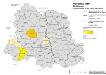
Vojvodina 1900. Ruthenen
Wojwodina ethnische Gruppe, Russinen Hofinger, Veronika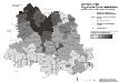
Vojvodina 1900. Ungarische Sprachkenntnisse
Wojwodina Ungarisch, Fremdsprachenkenntnis Hofinger, Veronika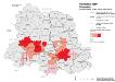
Vojvodina 1900. Slowaken
Wojwodina ethnische Gruppe, Slowaken Hofinger, Veronika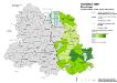
Vojvodina 1900. Rumänen
Wojwodina ethnische Gruppe, Rumänen Hofinger, Veronika
Carte von Temescher Banat
1 : 220000 Banát Péchy von Péchyujfalu
Sheet XIV: Karte Des Oesterreichischen Kaiserstaates.
1 : 576000 Scheda, Josef
Vojvodina 1900. Nationalitäten
Wojwodina ethnische Gruppe Hofinger, Veronika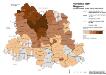
Vojvodina 1900. Magyaren
Wojwodina ethnische Gruppe, Magyaren Hofinger, Veronika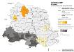
Vojvodina 1900. Kroaten
Wojwodina ethnische Gruppe, Kroaten Hofinger, Veronika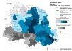
Vojvodina 1900. Serben
Wojwodina ethnische Gruppe, Serben Hofinger, Veronika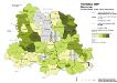
Vojvodina 1900. Deutsche
Wojwodina ethnische Gruppe, Deutsche Hofinger, Veronika
Ober Ungern
Rumunsko Kipferling, Karl Joseph im Verlage des Kunst und Industrie Comptoir's
Ober Ungern
Rumunsko Kipferling, Karl Joseph im Verlage des Kunst und Industrie Comptoir's
Tabula Bannatus Temesiensis a Geometris S.S.M.M.I.I. et R.A. confecta; quam in minorem formam reduxit, gradusque longitudinis, et latitudinis adjecit Franciscus Griselini. Augustinus Cipps sculpsit
1 : 480000 Temescher Banat Griselini, Francesco, http://d-nb.info/gnd/129735183; Cipps, Augustin, http://d-nb.info/gnd/130565644
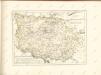
Ungarn:. Comitate: Baranya, Bács, Csanád, Temes, Torontal. Slavonien. Comit.: Sirmien, Veröcze. Militär Gränze: Brod, Petervardein, Csajkisten Kreisz, Deutschbanater Regiment
Ungarn Verkehrsweg
Augustissimo Romanor. Imperatori Iosepho I. Hungaria Regi Invictissimo Mappam Hanc Regni Hungariae
1 : 540000 Mollova mapová sbírka Müller, Johann Christoph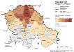
Vojvodina 1981. Magyaren (Madjari)
Wojwodina ethnische Gruppe, Magyaren Hofinger, Veronika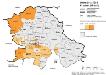
Vojvodina 1981. Kroaten (Hrvati)
Wojwodina ethnische Gruppe, Kroaten Hofinger, Veronika