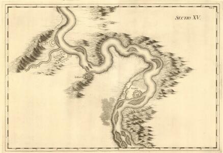
Maps of Bregovo
Orsawa - Widdin
Mollova mapová sbírka Marsili, Luigi Ferdinando
Carte des Sieges der K. Truppen unter Com.do des FZ. Gr: Clerfait über die bei Calefat unter Com.do
1 Karte : Kupferdruck ; 12 x 17 cm [Trattner]
Lambert-Cholesky sheet 2540 (Salcia)
1 : 20000 Romanian military topographic map sheet under Lambert-Cholensky projection Direcția Topografică Militară geo-spatial.org Direcția Topografică Militară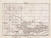
Lambert-Cholesky sheet 2539 (Kapetanovici)
1 : 20000 Romanian military topographic map sheet under Lambert-Cholensky projection Direcția Topografică Militară geo-spatial.org Direcția Topografică Militară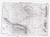
Lambert-Cholesky sheet 2541 (Vrața)
1 : 20000 Romanian military topographic map sheet under Lambert-Cholensky projection Institutul Geografic Militar geo-spatial.org Institutul Geografic Militar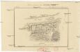
Plan sraženija pod Kalafatom
1 : 20000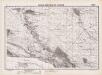
Lambert-Cholesky sheet 2640 (Cetate)
1 : 20000 Romanian military topographic map sheet under Lambert-Cholensky projection Institutul Geografic Militar geo-spatial.org Institutul Geografic Militar
Lambert-Cholesky sheet 2538 (Calafat)
1 : 20000 Romanian military topographic map sheet under Lambert-Cholensky projection Institutul Geografic al Armatei geo-spatial.org Institutul Geografic al Armatei
Lambert-Cholesky sheet 2639 (Maglavit)
1 : 20000 Romanian military topographic map sheet under Lambert-Cholensky projection Direcția Topografică Militară geo-spatial.org Direcția Topografică Militară
Lambert-Cholesky sheet 2641 (Braniştea)
1 : 20000 Romanian military topographic map sheet under Lambert-Cholensky projection Institutul Geografic Militar geo-spatial.org Institutul Geografic Militar
Lambert-Cholesky sheet 2638 (Poiana Mare)
1 : 20000 Romanian military topographic map sheet under Lambert-Cholensky projection Direcția Topografică Militară geo-spatial.org Direcția Topografică Militară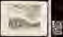
Grundlage der türkischen Vestung Widdin
1 Karte : Kupferdruck ; 12 x 17 cm [Trattner]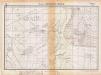
Lambert-Cholesky sheet 2441 (Pristolul )
1 : 20000 Romanian military topographic map sheet under Lambert-Cholensky projection Institutul Geografic Militar geo-spatial.org Institutul Geografic Militar
Zajecar
1 : 200000 Zaječar (Srbsko) Kartografska radionica
Harta Cailor de Comunicatie din Judetul Doljiu
Rumänien Judeţul Dolj Verkehrsweg
Carte des Scharmützels der K.K. Truppen unter Com.do des Obristleut Bey ohnweit Calefat in der Wala
1 Karte : Kupferdruck ; 12 x 17 cm [Trattner]
Carte des bei Negodin vorgefallenen Treffens zwischen den K.K. Truppen unter Com.do des Obristen Lip
1 Karte : Kupferdruck ; 12 x 17 cm [Trattner]
Plan von der Attaque deren Türcken unter den 28. Septembris 1737, alwo das unter Commando des Herrn Feld-Marschallen Grafen von Khevenhüller Excellenz stehende Corpo, ad kaiserl. Regimenter Cavallerie, 10. sächsische Esquadrons, und 11. Battaillons, von denen Türcken auf 5. Seiten attaquiret worden seynd, worgegen die Kaiserl. 7. Stunden lang gegen dem Feind tapfer resistiret, endlichen die Türcken gezwungen, das Champ de Battaille, nebst Hinterlassung vieler Todten zu abandoniren, und über die Timock sich zu retiriren
Lidl, Johann Jakob im Krausischer Buch-Laden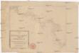
Die Shiffahrt auf der Donau von der Spitze Syrmiens bis in das Schwarze Meer
Bělehrad (Srbsko)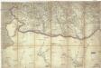
[Jižní Rumunsko]
Rumunsko
Bulgaria
Mollova mapová sbírka Hoffmann, Johannes Hoffmann, Johann
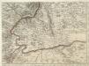
Theatrum belli inter imperat. Carol VI. et sult. Achmet IV. in partibus regnorum Serviae et Bosniae
Bulharsko Oettinger, Johann Friedrich Hommanianis Heredibus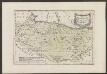
Des Koenigreichs Bulgarien Westliche Hälfte
1 : 1200000 Bulgarien (West)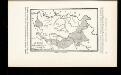
La Serbie de Karageorges et de 1833-78
Serbien Geschichte
Übersichtskarte von Mittel - Europa
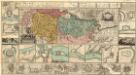
Augustissimo Romanor. Imperatori Iosepho I. Hungaria Regi Invictissimo Mappam Hanc Regni Hungariae
1 : 540000 Mollova mapová sbírka Müller, Johann Christoph
Théatre de la guerre dans le Bannat de Temeswar
1 : 400000 Banát Briffaut, Étienne Hochenleitter, Lucas Lucas Hochenleitter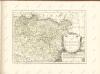
Regnum Bosniae, una cum finitimis Croatiae, Dalmatiae, Slavoniae, Hung. et Serviae partibus praecipuorum in his regionibus munimentorum ichnographia Curantibus
1 : 840000 Mollova mapová sbírka Ötinger, Johann Homann, Johann Baptista - dědici