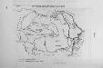
Maps of Romania

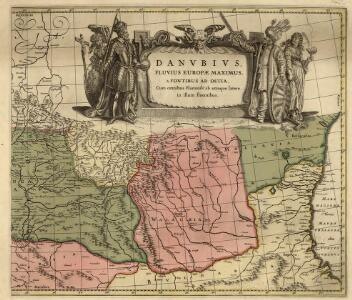
Danvbivs, Fluvius Europae Maximus
Mollova mapová sbírka Danckertsz, Cornelis Danckerts, Cornelis I. - dědici
Moldau, Walachei, Siebenburgen.
1 : 1863880 Flemming, Carl
Principatus Valachiae, Moldaviae, et Transylvaniae, divisus in singulares Populos cum finitimis Regionibus distinete ostenduntur
1 : 1100000 Mollova mapová sbírka Valk, Gerhard Valck, Gerard
Karte der Moldau und der angrenzenden Länder Oesterreichs (Ostgalizien und Siebenbürgen), Russlands (Bessarabien, Podolien, Volhynien, Kiew), dann der Wallachei und Dobrudscha
1 : 1500000 Besarábie (Moldavsko a Ukrajina)
Danubius Fluminum Europaerum Princeps
1 : 3200000 Mollova mapová sbírka Haupt, Gottfried Jacob Haupt, Gottfried Jacob
Karte von der Moldau, Wallachei u. Siebenbürgen nebst Theilen der angränzenden Länder
1 : 1863880 Moldavsko Handtke, Friedrich Flemming, C. C. Flemming
Principati di Moldavia

Danubii fluminis (hic ab urbe Belgrado, per Mare Nigrum usq[ue] Constantinopolim defluentis exhibiti) pars infima
1 Karte : Kupferdruck ; 46 x 57 cm Homann Johann Baptist Homann
Danubii fluminis (hic ab urbe Belgrado, per Mare Nigrum usq[ue] Constantinopolim defluentis exhibiti) pars infima
1 Karte : Kupferdruck ; 46 x 57 cm Homann Johann Baptist Homann
Novaja karta naměstničestv / Soč. J. Treskot
1 : 10900000 1 Karte : Kupferdruck ; 30 x 19 cm Truskot, Ivan Fomič [Verlag nicht ermittelbar]
Gouv. 34. Wilna, 35. Grodno, 36. Bialystock
1 : 2300000 1 Karte : Lithographie ; 26 x 19 cm Schlieben, W.E.A. von [Georg Joachim Göschen]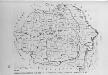
Verwaltungsgliederung 1918-1937
Rumänien Verwaltungsgliederung
Generalkarte Des Russischen Reichs mit der Eintheilung in die neu errichteten Statthalterschaften un
1 : 5600000 1 Karte auf 3 Blatt : Kupferdruck ; 79 x 171 cm ; Einzelbl. 79 x 57 cm Schraembl, Franz Anton Zu finden im eigenen Verlage in Wien
Danubii fluminis (hic ab urbe Belgrado, per Mare Nigrum usq[ue] Constantinopolim defluentis exhibiti)
1 : 2000000 Besarábie (Moldavsko a Ukrajina) Homann, Johann Baptist a Ioh. Bapt. Homanno
Danubii fluminis (hic ab urbe Belgrado, per Mare Negrum usq. Constantinopolim defluentis exhibiti)
1 : 2000000 Besarábie (Moldavsko a Ukrajina) Homann, Johann Baptist J. B. Homann
Danubii fluminis (hic ab urbe Belgrado, per Mare Nigrum usq[ue] Constantinopolim defluentis exhibiti)
1 : 2000000 Besarábie (Moldavsko a Ukrajina) Homann, Johann Baptist a Ioh. Bapt. Homanno
Danubii fluminis (hic ab urbe Belgrado, per Mare Nigrum usq[ue] Constantinopolim defluentis exhibiti)
1 : 2000000 Besarábie (Moldavsko a Ukrajina) Homann, Johann Baptist a Ioh. Bapt. Homanno
Danubii fluminis (hic ab urbe Belgrado, per Mare Nigrum usq. Constantinopolim defluentis exhibiti)
1 : 2000000 Besarábie (Moldavsko a Ukrajina) Homann, Johann Baptist J.B. Homann
Geologische-Übersichtskarte des Königreiches Rumänien
1 : 800000 Rumunsko Draghicenu, Mathei M. k. u. k. militär-geographisches Institut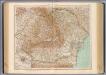
79-80. Romania.
1 : 1500000 Touring club italiano
Partie septentrio.le et meridionale de la Russie européenne Tartarie russienne et Petite Tartarie
1 : 13000000 1 Karte : Kupferdruck ; 23 x 21 cm [Collége de Maître-Gervais]
Prehľadná automapa Rumunska

Obščaja karta Vengrii i Transil'vanii
1 : 2700000 Maďarsko Beketov, V.
Danubii Fluminis Pars Infima
1 : 2000000 Mollova mapová sbírka Haupt, Gottfried Jacob Haupt, Gottfried Jacob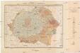
Harta solurilor României
1 : 1500000 Rumunsko Schön, R. Institutul geologic al României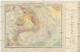
Harta geologică a României
1 : 1500000 Rumunsko Schön, R. Institutul geologic al României
Übersichtskarte von Rumänien
1 : 750000 Rakousko-Uhersko k. u. k. Hof- und Universitätsbuchhandlung R. Lechner (W. Müller)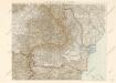
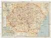
Karte von Rumanien
Turistická mapa Rumunska
Rumunsko Fáborský, Jan B. Nipočić, Vasilij Národní turistická kancelář