Maps of Liguria
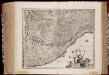
Ligvria Ò Stato Della Republica di Genoua
1 : 650000 Mollova mapová sbírka Magini, Fabio Magini, Fabio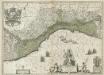
La Republique de Genes.
1 : 610000 Mollova mapová sbírka Blaeu, Willem Janszoon Covens, Johannes I
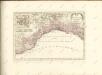
Nouvelle carte de l'etat de la republique de Genes
1 : 617000 Bastia (Francie) Ottens, Josua R. et I. Ottens
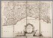
Carta geographica, la quale rappresenta lo stato della republica di Genova, partita nella Riviera di Levante et di Ponente
Janov (Itálie) per gli Heredi d'Homann.
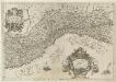
Topographia de la Liguria
1 : 170000 Mollova mapová sbírka Chafrion, José

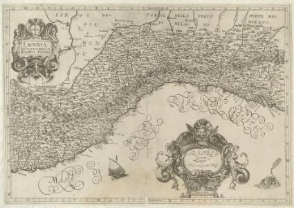
LIGVRIA, | ò Stato della Republica di | GENOVA
[Amsterdam : Joan Blaeu]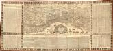
Le Due Riviere Di Genoua Con Il Oro Confini cauate dalle Relazioni di molti Virtuosidi questa Serma. domina. da Ludco. della Spina Prof. di Geogr
1 : 320000 Mollova mapová sbírka Lépine, Louis de
Lo Stato della Repubblica di Genova
1 : 400000 giusta la di lui divisione in contorno orientale et occidentale geograficamente rappresentato et di nuovo dato in luce da Tobia Cunrado Lottero Augusta : [Tobias Conrad Lotter]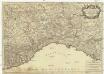
Partie du duché de Milan, la principauté de Piemont, le Montferrat, et la republique de Genes
1 : 430000 Clermont-Ferrand (Francie) Jaillot, Alexis-Hubert chez H. Iaillot


Etats de la seigneurie et republique de Gènes : dressée sur les meilleures cartes
1 : 360000 Venise : Remondini
MAPPA GEOGRAPHICA STATVS GENVENSIS
1 : 460000 Janov-oblast (Itálie) Mayer, Tobias Chafrion, José in lucem proferentibus Homannianis Heredibvs
MAPPA GEOGRAPHICA STATVS GENVENSIS
1 : 460000 Janov-oblast (Itálie) Mayer, Tobias Chafrion, José in lucem proferentibus Homannianis Heredibvs
Lo stato della repubblica di Genova
Janov-oblast (Itálie) Lotter, Tobias Conrad Doyen da Tobia Cunrado Lottero
REIPUBLICAE GENUENSIS DOMINIUM
1 : 630000 Janov-oblast (Itálie) Seutter, Matthäus per Matth. Seutter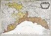
Partie du duché de Milan, la principauté de Piémont, le Montferrat; et la republi.que de Genes
1 Karte : Kupferdruck ; 45 x 63 cm Jaillot; Simonneau chez H. Iaillot geographe ordinaire du roy proche les grands Augustins aux 2. globes
Status Reipublicae Genuensis
1 : 600000 Mollova mapová sbírka Homann, Johann Baptist Homann, Johann Baptista - dědici
Republicae Genuensis Dominium
1 : 600000 Mollova mapová sbírka Seutter, Matthäus Seutter, Matthäus
Riviera Di Genova Da Ponente [Karte], in: Novus Atlas, das ist, Weltbeschreibung, Bd. 3, S. 60.
1 Karte aus Atlas Blaeu, Joan Blaeu, Willem Janszoon
Riviera Di Genova Da Ponente [Karte], in: Le théâtre du monde, ou, Nouvel atlas contenant les chartes et descriptions de tous les païs de la terre, Bd. 3, S. 48.
1 Karte aus Atlas Blaeu, Willem Janszoon und Blaeu, Joan Blaeu, Willem Janszoon
RIVIERA | DI GENOVA DA | PONENTE
[Amsterdam : Joan Blaeu]
Riviera Di Genova Di Ponente [Karte], in: Novus atlas absolutissimus, Bd. 5, S. 99.
1 Karte aus Atlas Janssonius Offizin
Carta Geographica, la quale rappresenta lo Stato della Republica di Genova partita nella Riviera di Levante et di Ponente
1 : 460000 Mollova mapová sbírka Homann, Johann Baptist Homann, Johann Baptista - dědici
Lo Stato della republica di Genova
Janov (Itálie) Lotter, Tobias Conrad da Tobia Conrado Lottero