Maps of Noceto

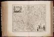
Dvcato di Modena Regio et Carpi
1 : 320000 Mollova mapová sbírka Magini, Fabio Magini, Fabio
Pianta della città di Parma = plan de la ville de Parme
Allodi inc. ; Ferd. Artaria et fils. Milan
Parma
Parma
Parma (Itálie) Braun, Georg Hogenberg, Franz
Plan van den veldslag bij Parma tusschen de Keizerschen, en geallieerde Fransen en Savojaarden, op den 29.st Juny 1734
[S.l.] : [s.n.]
Plan de la bataille de Parme, gagnée le 29 Juin 1734 par l'armée des deux couronnes alliées sur celle de l'Empereur
[par J. B. Nolin] Te Amsterdam : bij Hendrik de Leth, kaartverkoper op de Beurssluys
Plan von der Stadt Mirandola A°. 1735. von den Spaniolen belagert und nach einer langen und vigouresen Defension endlich erobert worde[n]
1 : 4300 Mirandola (Itálie) Du Chaffat, Antoine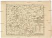
Schau-Platz deren zu Hungarn und Böheim königl. Majestät siegreichen Waffen, so in Italien zwischen Campo Santo und Solara an dem Fluß Panaro den 8ten Febr. Annô 1743 vorgefallen ist
1 : 250000 Camposanto (Itálie) Lidl, Johann Jakob durch J.J. Lidl
Gvastalla Sampt dero Gegend
1 : 220000 Mollova mapová sbírka Bodenehr, Gabriel Bodenehr, Gabriel
Kleine und aufrichtige Land-Karten von denen Herzogthümern Mantua, Modena, Parma, und Mirandola
Mollova mapová sbírka
Ducatus Mutinensis Regiensis et Carpiensis
1 : 260000 Mollova mapová sbírka Seutter, Matthäus Seutter, Matthäus

Ducatus Mantuani, ceu sedis belli 1733-35 recentissima delineatio
1 Karte : Kupferdruck ; 46 x 57 cm Homännische Erben
Ducatus Mantuani, ceu sedis belli 1733-35 recentissima delineatio
1 Karte : Kupferdruck ; 46 x 57 cm Homännische Erben
Carte Nouvelle Du Duché De Modene De Regio et de Capri Avec la Seigneurie de la Cafargnana &c: [...] [Karte] , in: Atlas nouveau, contenant toutes les parties du monde [...], Bd. 2, S. 188.
1 Karte aus Atlas Sanson, Nicolas Jaillot, Alexis Hubert und Mortier, Pieter
DVCATO | DI | MODENA, | REGIO | ET CARPI, | Col Dominio | della | Carfagnana.
Apud Guiljelmum | et Joannem Blaeu.
Ducato Di Modena Regio Et Carpi, Col Dominio della Carsagnana. [Karte], in: Le théâtre du monde, ou, Nouvel atlas contenant les chartes et descriptions de tous les païs de la terre, Bd. 3, S. 78.
1 Karte aus Atlas Blaeu, Willem Janszoon und Blaeu, Joan Blaeu, Willem Janszoon
Kriegs Karte von denen Operationen und Lagern, welche bey dem Corps der Armée der Kayserlichen Königlichen aus Teutschland in Italien angelangten Trouppen von dem Monath Mertz 1746 bis 6 April 1746 unter Commando des Herrn General Feld Zeugmeisters Graf v. Bourne Excellenz, als dieses Corps am Taro Fluss bis zu des Fürst von Lichtensteins Durchlaucht hohen Ankunfft den 10 April zu stehen gekommen, vorgegangen sind ans Licht gestellt
Guastalla (Itálie) Homänischen Erben
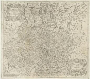
STATVS MVTINENSIS IN SVAS DITIONES utpote DVCATVM MVTINENSEM, REGINENSEM, MIRANDVLANVM, PRINCIPATVM CARPIENSEM ET CORREGIENSEM exacte divisi, nec non finitimarum Regionum novissima Tabula
1 : 250000 Carpi (Itálie) sumptibus Homan[n]ianorum Heredum
STATVS MVTINENSIS IN SVAS DITIONES utpote DVCATVM MVTINENSEM, REGINENSEM, MIRANDVLANVM, PRINCIPATVM CARPIENSEM ET CORREGIENSEM exacte divisi, nec non finitimarum Regionum novissima Tabula
1 : 250000 Carpi (Itálie) sumptibus Homan[n]ianorum Heredum
Statvs Mvtinensis in svas ditiones utpote dvcatvm Mvtinensem, Reginensem, Mirandvlanvm, principatvm Carpiensem et Corregiensem exacte divisi, nec non finitimarum regionum novissima tabula
1 : 250000 Carpi (Itálie) sumptibus Homan[n]ianorum Heredum
Ducato Di Modena Regio Et Carpi, Col dominio della Carsagnana. [Karte], in: Theatrum orbis terrarum, sive, Atlas novus, Bd. 3, S. 76.
1 Karte aus Atlas Blaeu, Joan Blaeu, Willem Janszoon
Ducato Di Modena Regio Et Carpi, Col Dominio della Carsagnana. [Karte], in: Novus Atlas, das ist, Weltbeschreibung, Bd. 3, S. 90.
1 Karte aus Atlas Blaeu, Joan Blaeu, Willem Janszoon
Carte nouvelle du Duché de Modene, de Regio et de Carpi, avec la seigneurie de la Cafargnana &c. : levée par ordre exprès à l' usage des armées en Italie, où sont exactement marques les grands chemins, les routes des imperiaux &c.
1 : 200000 par le Sr. Sanson, Geograph. du Roy A Amsterdam : chez Pierre Mortier
Generalkarte von Zentraleuropa

Generalkarte von Zentraleuropa

Ducato Di Modena Regio et Carpi Col Dominio della Carsagnana [Karte], in: Novus atlas absolutissimus, Bd. 5, S. 139.
1 Karte aus Atlas Janssonius Offizin

Carta della provincia di Mantova
Mantova-oblast (Itálie) Karacsay, F.