Maps of Istria County
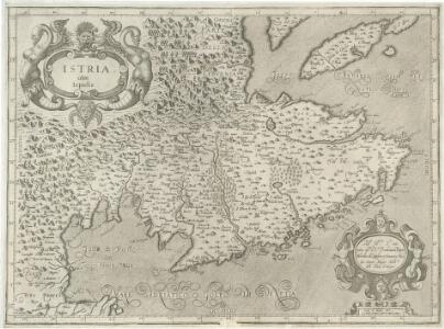
Istria olim Iapidia
1 : 300000 Mollova mapová sbírka Magini, Giovanni Antonio Magini, Fabio

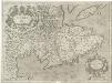
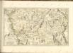
Istria olim Iapidia
1 : 310000 Istrijský poloostrov (Slovinsko a Chorvatsko) Janssonius, Johannes sumptibus Ioannis Ianssonii
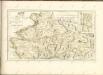
Istria olim Iapidia [Karte], in: Le théâtre du monde, ou, Nouvel atlas contenant les chartes et descriptions de tous les païs de la terre, Bd. 3, S. 155.
1 Karte aus Atlas Blaeu, Willem Janszoon und Blaeu, Joan Blaeu, Willem Janszoon
Istria olim Iapidia [Karte], in: Theatrum orbis terrarum, sive, Atlas novus, Bd. 3, S. 131.
1 Karte aus Atlas Blaeu, Joan Blaeu, Willem Janszoon
ISTRIA | olim | IAPIDIA.
[Amsterdam : Joan Blaeu]
Istria olim Iapidia [Karte], in: Novus Atlas, das ist, Weltbeschreibung, Bd. 3, S. 151.
1 Karte aus Atlas Blaeu, Joan Blaeu, Willem Janszoon
Adriatisches Meer, Küstenkarte
1 : 180000 Istrijský poloostrov (Slovinsko a Chorvatsko) Oesterreicher, Tobias von Hydrographisches Amt der k. u. k. Kriegsmarine
Adriatisches Meer, Küsten-Karte
1 : 180000 Istrijský poloostrov (Slovinsko a Chorvatsko) Oesterreicher, Tobias von Hydrographisches Amt der k. u. k. Kriegs-Marine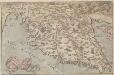
Histriae tabula
Istrien Coppo. Pietro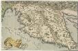
Histriae tabula
1 : 400000 Mollova mapová sbírka Coppo, Pietro Ortelius, Abraham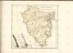

Pinguent und Volosca.
from Spezialkarte der osterreichisch-ungarischen Monarchie.
Mitterburg und Fianona.
from Spezialkarte der osterreichisch-ungarischen Monarchie.
Sesana und St. Peter.
from Spezialkarte der osterreichisch-ungarischen Monarchie.
Cittanuova und Montona.
from Spezialkarte der osterreichisch-ungarischen Monarchie.
Parenzo und Rovigno.
from Spezialkarte der osterreichisch-ungarischen Monarchie.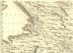
Ducatus Carnioliae Tabula Chorographica Iusu Sumptuque inclytorum Provinciae Statuum.
1 : 100000 Mollova mapová sbírka Florjančič de Grienfeld, Janez Dizma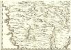
Ducatus Carnioliae Tabula Chorographica Iusu Sumptuque inclytorum Provinciae Statuum.
1 : 100000 Mollova mapová sbírka Florjančič de Grienfeld, Janez Dizma
Triest.
from Spezialkarte der osterreichisch-ungarischen Monarchie.
Istrien
1 : 60000 Istrijský poloostrov (Slovinsko a Chorvatsko) Oesterreicher, T. Hydrographisches Amt der K. u. k. Kriegsmarine, Seekartendepot
Italy 1:100,000 / Sardinia 1:100,000, Trieste
Italy 1:100,000 / Sardinia 1:100,000 , Series GSGS 4164. Great Britain. War Office. General Staff. Geographical Section. [London] : War Office
Carta idrografica del golfo di Trieste
1 : 160500
Carta geologica dei dintorni di Trieste
1 : 144000 Terst (Itálie) Marchesetti, Carlo Sencig, G.
Zone 23, Kol. IX, Triest, uit: Geologische Karte der im Reichsrathe vertretenen Königreiche und Länder der Österreich-Ungarischen Monarchie : auf Grundlage der Specialkarte i.M. 1:75.000 des k.u.k. Militär-geographischen Institutes / neu bearb. und als Kartenwerk von 341 Blattnummern in zwanglosen Lfg. hrsg. durch die k.k. Geologische Reichsanstalt in Wien
1 : 75000 titelvariant: Geologische Spezialkarte der im Reichsrate vertretenen Königreiche und Länder der Österreichisch-Ungarischen Monarchie; Geologische Specialkarte der im Reichsrathe vertretenen Königreiche und Länder der Österreichisch-Ungarischen Monarchie; Annotatie: Titel bovenaan kaartblad: Geologische Spezialkarte der im Reichsrate vertretenen Königreiche und Länder der Österreichisch-Ungarischen Monarchie en Geologische Specialkarte der im Reichsrathe vertretenen Königreiche und Länder der Österreichisch-Ungarischen Monarchie; Annotatie geografische gegevens: Coördinaten gebaseerd op nulmeridiaan van Ferro (Hierro) Kaiserlich-Königliche Geologische Reichsanstalt, Wenen Wien : K.K. Geologische Reichsanstalt
Istrien
Istrijský poloostrov (Slovinsko a Chorvatsko) Mach, G. Hydrographisches Amt der K. u. k. Kriegsmarine, Seekarten-Depot
Umgebungskarte von Triest