Maps of Sitia
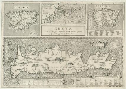
Creta louis magni, medio iacet insula ponto
1 : 1200000 Mollova mapová sbírka Ortelius, Abraham
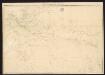
Een gedeelte van het eijland Candia vertoonende de de Noord Oost zijde
Greece Gerard van Keulen
Greece 1:250, 000, Iraklion (Candia)
Greece 1:250,000 , Series GSGS 4410. Great Britain. War Office. [London] : War Office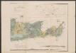
Carte orographique et géognostique de l'île de Crête
1 : 300000 Ostblatt Raulin, Victor R. Janson
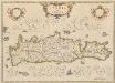
Candia cum insulis aliquot circa Græciam
1 Karte : Kupferdruck ; 22 x 46 cm, Bildgrösse 34 x 48 cm Mercator; Hondius Henricus Hondius
Candia cum insulis aliquot circa Græciam
1 Karte : Kupferdruck ; 22 x 46 cm, Bildgrösse 34 x 48 cm Mercator s.n.
Carte orographique et géognostique de l'île de Crête (H KPHTH)
1 : 300000 Ostblatt Raulin, Victor R. Janson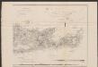
Carte orographique et géognostique de l'île de Crête
1 : 300000 Ostblatt Raulin, Victor R. Janson
Candia
Mollova mapová sbírka Merian, Matthaeus Merian, Matthäus - dědici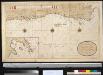
Een gedeelte van het eijland Candia vertoonende de Zuijd Oost zijden
Greece Gerard van Keulen
[INSULA CRETA hodie CANDIA]
1 : 925000 Egejské moře-oblast Homann, Johann Baptist Ioh. Bapt. Homannus
Isle et royaume de Candie
1 : 810000 Kréta (Řecko) Sanson, Nicolas Cordier, Louis Pierre Mariette

Insula Creta nunc Candia in sua 4 territoria distincta, cum aliquod adjacentibus AEgei maris insulis imprimis Nova Santorini insula modo ante 27 annos ex Abysso Maris emersa
1 : 930000 Kréta (Řecko) Seutter, Matthäus M. Seutter
Candia, olim Creta. [Karte], in: Le théâtre du monde, ou, Nouvel atlas contenant les chartes et descriptions de tous les païs de la terre, Bd. 3, S. 309.
1 Karte aus Atlas Blaeu, Willem Janszoon und Blaeu, Joan Blaeu, Willem Janszoon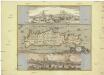
Insula Candia olim Creta
Kréta (Řecko) Weiland, Karl Ferdinand Visscher, Nicolaus N. Visscher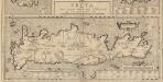
Creta Iovis magni, medio iacet insula ponto. [Karte], in: Theatrum orbis terrarum, S. 520.
1 Karte aus Atlas Ortelius, Abraham Vrients, Jan Baptista
Candia, olim Creta. [Karte], in: Theatrum orbis terrarum, sive, Atlas novus, Bd. 3, S. 297.
1 Karte aus Atlas Blaeu, Joan Blaeu, Willem Janszoon
Insula Creta nunc Candia
1 : 900000 Kréta (Řecko) Lotter, Tobias Conrad Tob. Conr. Lotter

Candia olim Creta
1 : 3830000 Kréta (Řecko)
Candia, olim Creta. [Karte], in: Novus Atlas, das ist, Weltbeschreibung, Bd. 3, S. 349.
1 Karte aus Atlas Blaeu, Joan Blaeu, Willem Janszoon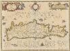
Candia olim Creta. [Karte], in: Novus atlas absolutissimus, Bd. 5, S. 294.
1 Karte aus Atlas Janssonius Offizin
Insula Candia olim Creta. [Karte], in: Novus atlas absolutissimus, Bd. 9, S. 317.
1 Karte aus Atlas Janssonius Offizin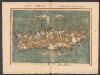
Tabula Neoterica Crete Sive Candie Insule [Karte], in: Claudii Ptolemei viri Alexandrini mathematice discipline philosophi doctissimi geographie opus [...], S. 281.
1 Karte aus Atlas Waldseemüller, Martin [und Ptolemaeus, Claudius] Übelin, Georg
[83][83] Insula Candia ..., uit: Atlas sive Descriptio terrarum orbis
Annotatie: Gedigitaliseerde versie. Amsterdam. Heiloo : Picturae (vervaardiger), 2015. tiff-bestand. Gedigitaliseerd: 07-01-2015; Origineel: Universiteitsbibliotheek Vrije Universiteit (XL.05127.-) ; Netherlands; Titelpagina ontbreekt Wit, Frederik de Amsterdam : Frederick de Wit
Insula Creta hodie Candia
1 : 900000 Kréta (Řecko) Homann, Johann Baptist Joh. Bapt. Homannus
CANDIA, | olim | CRETA
[Amsterdam : Joan Blaeu]