Maps of Romania

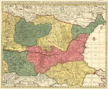
Exactissima Tabula, qua tam Danubii Fluvii Pars Inferior
1 : 2000000 Mollova mapová sbírka Visscher, Nicolaes Jansz. Schenk, Peter II
Theatrum belli ad Borysthenem Tyram & Danubium fluvios
1 : 1900000 Balkánský poloostrov Academia scientiarum Petropolitana
Neu und Accurat vefasste General Post Land-Karte des sehr grossen Welt berühmten Konig-Reichs Hungarn
1 : 1400000 Mollova mapová sbírka Lidl, Johann Jakob Lidl, Johann Jacob
Theatrum Belli ad Borysthenem Tyram & Danubium Fluvios gesti Ao MDCC XXXVIII
1 : 1900000 Mollova mapová sbírka
DANUBII FLUMINIS hic ab urbe BELGRADO per Mare Nigrum usq[ue] CONSTANTINOPOLIM defluentis exhibiti
1 : 2020000 Besarábie (Moldavsko a Ukrajina) Homann, Johann Baptist a Ioh. Bapt. Homanno

Illyricum Orientis
1 : 2900000 Mollova mapová sbírka Sanson, Nicolas Covens, Johannes I
Tabula Hungaria et regionum, quae praeterea ab ea dependent
1 : 2100000 Maďarsko Delisle, Guillaume Lotter, Georg F. T. C. Lotter
Accurate Landkarte die Königreiche Ober- und Nieder- Hungarn, Slavonien, Croatien, Dalmatien, Bosnien, Servien, Bulgarien, und Romanien, das Groß Fürstenthum Siebenbürgen, die Fürstenthümer Moldau, Wallachen, Bessarabien, die Oczakowisch- und Crimische Tartaren, die pohlnische Provinz Podolien, wie auch ein Theil von Ukranien, und übrige angränzende Ländern vorstellend
1 : 1430000 Besarábie (Moldavsko a Ukrajina) Lidl, Johann Jakob Joh. Jacob Lidl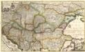
Accurate Landkarte die Königreiche
1 : 1400000 Mollova mapová sbírka Lidl, Johann Jakob Lidl, Johann Jacob
Accurate Landkarte die Königreiche
1 : 1400000 Mollova mapová sbírka Lidl, Johann Jakob Lidl, Johann Jacob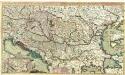
Theatre de la Guerre en Hongrie, Bosnie, Servie, et Tartarie Crimee, en il Grandes Feuilles
1 : 2000000 Mollova mapová sbírka Briffaut, Etienne Briffaut, Etienne
Daciarum, Moesiarumque, Vetus Descriptio. [Karte], in: Theatrum orbis terrarum, S. 505.
1 Karte aus Atlas Ortelius, Abraham Vrients, Jan Baptista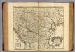
Hongrie.
1 : 2550000 L'Isle, Guillaume de, 1675-1726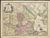
Theatrum belli ad Borysthenem, Tyram et Danubium fluvios, gesti Ao MDCCXXXVIII
1 : 2450000 excus in Academia Scientiarum Petropolitana Hagae Comitum : apud Joan. Block
Carte de la Hongrie et partie septentrionale de la Turquie
Ungarn, Osmanisches Reich L'Isle, Guillaume de
Carte de la Hongrie
1 : 2500000 Mollova mapová sbírka Delisle, Guillaume Liébaux L'Isle, Guillaume de
Tabula Hungaria
1 : 2500000 Mollova mapová sbírka Delisle, Guillaume Seutter, Matthäus Wolff, Jeremias
Tooneel des oorlogs aan den Dnieper, Tira en Donauw in den jare 1738 gevoerd
1 : 2500000 I. Punt del. et fecit I. en G. Kondet sculp
Hongrie, pays qui en dependoient autrefois.
1 : 2550000 L'Isle, Guillaume de, 1675-1726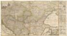
Accurate Landkarte die Königreiche Ober- und Nieder- Hungarn, Slavonien, Croatien, Dalmatien, Bosnien, Servien, Bulgarien und Romanien, das Gross Fürstenthum Siebenbürgen, die Fürstenthümer Moldau, Wallachen, Bessarabien, die Oczakowisch- und Crimische Tartaren, die Pohlnische Provinz Podolien, wie auch ein Theil von Ukranien, und übrige angränzende Ländere vorstellend
1 : 1430000 Besarábie (Moldavsko a Ukrajina) Lidl, Johann Jakob Joh. Jacob Lidl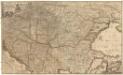
Le Royaume de Hongrie...

Exactissima tabula, qua tam Danubii fluvii pars inferior, a Belgrado urbe usq ad ejus ostia, et minores in eum influentes fluvii, quam regiones adjacentes, ut Transylvania, Valachia, Moldavia, Bulgaria, Bessarabia et Romonia, aliiq Ucraniae ac Podoliae tractus finitimi ostenduntur / per Nicolaum Visscher Amst. Bat
1 : 2000000 Annotatie: Cum privilegio Ordin. General. Belgii Foederati; Annotatie geografische gegevens: Met 4 schaalstokken; Legenda Nicolaes Jansz. Visscher jr. 1649-1702 Amst. Bat. : Nicolaum Visscher
Danubii fluminis (hic ab urbe Belgrado, per Mare Nigrum usq Constantinopolim defluentis exhibiti) pars infima, in qua Transylvania, Walachia, Moldavia, Bulgaria, Servia, Romania et Bessarabia cum vicinis regionibus ostenduntur
Balkanhalbinsel, Donau, Flusslauf Homann, Johann Baptist
Le Royaume de Hongrie et des pays qui en dependoient autrefois ; Nova et accurata Regni Hungariae tabula, ad usum serenissimi Burgundiae ducis
Ungarn, Osmanisches Reich L'Isle, Guillaume de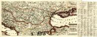
Regni Hungariae et Provinciarum adjacentium Tartariae minoris, ac Grimeae delineatio Geographica
Mollova mapová sbírka
Daciarum, Moesiarumque, Vetus Descriptio. [Karte], in: Theatrum orbis terrarum, S. 410.
1 Karte aus Atlas Ortelius, Abraham
[Ost-Europa, Blatt 5]
Adolf Stieler's Handatlas über alle Theile der Erde und über das Weltgebäude Stieler, Adolf Justus Perthes