Maps of Landkreis Wesermarsch

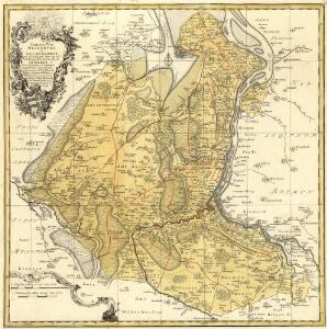
Comitatvvm Oldenbvrg et Delmenhorst
1 : 170000 Mollova mapová sbírka Hunrichs, Johann Wilhelm Anton Homann, Johann Baptista - dědici

OLDENBVRG | COMITATVS.
E. Sijmonsz. Hamersveldt sculp. [Amsterdam : Joan Blaeu]
Oldenburg Comitatus [Karte], in: Gerardi Mercatoris et I. Hondii Newer Atlas, oder, Grosses Weltbuch, Bd. 1, S. 155.
1 Karte aus Atlas Mercator, Gerhard und Hondius, Jodocus Jansson, Jan
Oldenbvrg Comit.
1 : 250000 Mollova mapová sbírka Michaelis, Laurentius Plantin, Christoph
Oldenburg Comitatus [Karte], in: Theatrum orbis terrarum, sive, Atlas novus, Bd. 1, S. 200.
1 Karte aus Atlas Blaeu, Joan Blaeu, Willem Janszoon
Oldenburg Comitatus [Karte], in: Novus Atlas, das ist, Weltbeschreibung, Bd. 1, S. 123.
1 Karte aus Atlas Blaeu, Joan Blaeu, Willem Janszoon
Comitatvvm Oldenbvrg et Delmenhorst
1 : 166000 Oldenburg (Německo) Hunrichs, Johann Wilhelm Anton Münnich, Anton Günther von Homannianorum heredum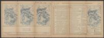
Oldenburg Comitatus [Karte], in: Le théâtre du monde, ou, Nouvel atlas contenant les chartes et descriptions de tous les païs de la terre, Bd. 1, S. 154.
1 Karte aus Atlas Blaeu, Willem Janszoon und Blaeu, Joan Blaeu, Willem Janszoon
Oldenburg Comitatus [Karte], in: Novus atlas absolutissimus, Bd. 2, S. 109.
1 Karte aus Atlas Janssonius Offizin
Oldenbvrg Comitatvs.
1 : 190000 Mollova mapová sbírka Aveele, Johannes van den
Oldenbvrg Comitatvs
1 : 190000 Mollova mapová sbírka Aveele, Johannes van den
Bremen 44, uit: Special-Karte von Mittel-Europa / nach amtlichen Quellen bearbeitet von W. Liebenow
1 : 300000 titelvariant: W. Liebenow's Mittel-Europa; Annotatie: Titel boven de bladen: W. Liebenow's Mittel-Europa Johannes Wilhelm Liebenow 1822-1897 Frankfurt a. M. : Ludwig Ravenstein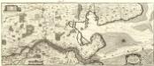
Nobilis Saxoniae Fl. Visvrgis cum Terris adjacentib. Ab Inclyta Brema ad Ostium Maris
1 : 130000 Mollova mapová sbírka Merian, Matthaeus Merian, Matthäus - dědici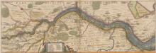
Nobilis Saxoniae Fl. Visurgis, cum Terris adjacentib. Ab Inclyta Brema, ad ostium maris. [Karte, Teil 1], in: Novus atlas absolutissimus, Bd. 2, S. 100.
1 Karte aus Atlas Janssonius Offizin
205. Oldenburg. (Germany)
1 : 100000 Reichsamt fur Landesaufnahme
55. Oldenburg, uit: Topographische Uebersichtskarte des Deutschen Reiches / herausgegeben v. d. Kartogr. Abt. d. Königl. Preuß. Landesaufnahme
1 : 200000 titelvariant: Topogr. Übersichtskarte des Deutschen Reiches; Annotatie: Titel boven bladen ook: Topogr. Übersichtskarte des Deutschen Reiches; Annotatie geografische gegevens: Op elk blad twee maatstokken: 10 Kilometer = 5,5 cm; 1 geogr. Meile = 3,6 cm; Legenda onder op elk blad Königlich Preußische Landesaufnahme. Kartographische Abtheilung [S.l : Königlich Preußische Landesaufnahme, Kartographische Abtheilung]
Composite: 205. Oldenburg. (Germany)
1 : 100000 Reichsamt fur Landesaufnahme
174. Varel. (Germany)
1 : 100000 Reichsamt fur Landesaufnahme
Composite: 175. Brake. (Germany)
1 : 100000 Reichsamt fur Landesaufnahme
Composite: 174. Varel. (Germany)
1 : 100000 Reichsamt fur Landesaufnahme
206. Bremen. (Germany)
1 : 100000 Reichsamt fur Landesaufnahme
175. Brake. (Germany)
1 : 100000 Reichsamt fur Landesaufnahme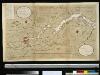
Afteekening van de rivier de Weeser, van de stad Brema tot 't eijland Hamelwerdersand in 't groodt
Germany Gerard van Keulen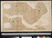
Afteekening van de rivier de Weeser van 't eijland Hamelweerdersand tot aan de Swarten Gronden in 't groot
Germany Gerard van Keulen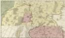
Comitatus Oldenburgensis]
Mollova mapová sbírka Loon, Jan van Schenk, Peter I
Meßtischblatt 1524 : Syke, 1935
1 : 250000 Syke. - Hrsg. 1900, kl. Nachtr. 1925, [gedr.] [19]35. - 1:25000. - [Berlin]: Reichsamt für Landesaufnahme, 1935. - 1 Kt.
Meßtischblatt 1523 : Harpstedt, 1938
1 : 250000 Harpstedt. - Hrsg. 1900, einz. Nachtr. 1938. - 1:25000. - [Berlin]: Reichsamt für Landesaufnahme, 1938. - 1 Kt.
Meßtischblatt 1522 : Dötlingen, 1935
1 : 250000 Dötlingen. - Hrsg. 1900, einz. Nachtr. 1925, [gedr.] [19]35. - 1:25000. - [Berlin]: Reichsamt für Landesaufnahme, 1935. - 1 Kt.