Maps of Lindau (Bodensee)

Veriungter Abriss Deß Heyl. Reichs Statt Lindaw, vnd derselben theils Alliglicher, theils allein Nidergerichtlicher Oberkeit
Mollova mapová sbírka Rauch, Johann Andreas
Veriungter Abriss des Heyl. Reichs Statt Lindaw, vnd derselben theils Alliglicher, theils allein Nidergerichtlicher Oberkeit aus der
Mollova mapová sbírka Rauch, Johann Andreas
Veriungter Abriss des Heyl. Reichs Statt Lindaw, vnd derselben theils Allieglicher, theils allein Nidergerichtlicher Oberkeit aus der
Mollova mapová sbírka Rauch, Johann Andreas
Veriungter Abriss des Heyl. Reichs Statt Lindaw, vnd derselben theils Allieglicher, theils allein Nidergerichtlicher Oberkeit aus der
Mollova mapová sbírka Rauch, Johann Andreas
CIVITATIS IMP. | LINDAVIENSIS | TERRITORIVM.
ita Delineabat | Iohannes Andreas Rauhen. [Amsterdam : Joan Blaeu]
Plan zur zweiten Kriegs-Uebung im Jahr 1846
1 : 25000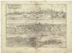
Nvrnberga florentißimum Germaniae emporium, rempub. optima politia illustre, et in burggrauior s. impeii ordine, alter. dignitatis locu habet
Lindau (Bavorsko, Německo) Braun, Georg Hogenberg, Franz
Meßtischblatt [8324] : Neukirch (Württ.), Achberg (Preuß.), 1911
1 : 250000 Neukirch (Württ.), Achberg (Preuß.). - Hrsg. 1895, 2. Ausg., 1911. - 1:25000. - Stuttgart, 1911. - 1 Kt.
Meßtischblatt [8224] : Waldburg, 1908
1 : 250000 Waldburg. - 1:25000. - Stuttgart, 1908. - 1 Kt.
Meßtischblatt [8124] : Reute, 1913
1 : 250000 Reute. - 1:25000. - Stuttgart, 1913. - 1 Kt.
Meßtischblatt [8024] : Waldsee, 1914
1 : 250000 Waldsee. - 1:25000. - Stuttgart, 1914. - 1 Kt.
Meßtischblatt [7924] : Biberach, 1915
1 : 250000 Biberach. - 1:25000. - Stuttgart, 1915. - 1 Kt.
Meßtischblatt [8323] : Tettnang, 1908
1 : 250000 Tettnang. - 1:25000. - Stuttgart, 1908. - 1 Kt.
Meßtischblatt [8223] : Ravensburg, 1908
1 : 250000 Ravensburg. - 1:25000. - Stuttgart, 1908. - 1 Kt.
Meßtischblatt [8123] : Weingarten, 1914
1 : 250000 Weingarten. - 1:25000. - Stuttgart, 1914. - 1 Kt.
Meßtischblatt [8023] : Altshausen, 1914
1 : 250000 Altshausen. - 1:25000. - Stuttgart, 1914. - 1 Kt.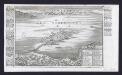
Lindau im Boden See
Bodenehr, Gabriel
Plan zur dritten Kriegs-Uebung im Jahr 1846
1 : 25000
Die Lande der Reichs=Erb=Truchsessen zu Waldburg
1 Karte : Kupferdruck ; 22 x 24 cm Reilly F. J. J. von Reilly
Constanz - Lindau
1 : 200000 Herder, Benjamin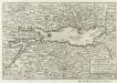
Bodensee alias Lacus Bodamicus Acronius, Brigantinus
1 : 270000 Mollova mapová sbírka Person, Nikolaus Person, Nicolas
187. Lindau, uit: Topographische Uebersichtskarte des Deutschen Reiches / herausgegeben v. d. Kartogr. Abt. d. Königl. Preuß. Landesaufnahme
1 : 200000 titelvariant: Topogr. Übersichtskarte des Deutschen Reiches; Annotatie: Titel boven bladen ook: Topogr. Übersichtskarte des Deutschen Reiches; Annotatie geografische gegevens: Op elk blad twee maatstokken: 10 Kilometer = 5,5 cm; 1 geogr. Meile = 3,6 cm; Legenda onder op elk blad Königlich Preußische Landesaufnahme. Kartographische Abtheilung [S.l : Königlich Preußische Landesaufnahme, Kartographische Abtheilung]
Lacus Bodamicus vel Acronius cum regionibus circumjacentibus recens delineatus
1 : 170000 Mollova mapová sbírka Seutter, Matthäus Seutter, Matthäus
Lacus Bodamicus vel Acronius cum regionibus circumiacentibus
Seutter, Matthäus Probst
Lacus Bodamicus vel Acronius
1 Karte : Kupferdruck ; 46 x 54 cm Probst; Seutter anjezo in Verlag bey Ioh. Michael Probst Chalc
Lacus Bodamicus vel Acronius
1 Karte : Kupferdruck ; 46 x 54 cm Probst; Seutter anjezo in Verlag bey Ioh. Michael Probst Chalc
Lacus Bodamicus vel Acronius
1 Karte : Kupferdruck ; 46 x 54 cm Probst; Seutter anjezo in Verlag bey Ioh. Michael Probst Chalc
Lacus Bodamicus vel Acronius
1 Karte : Kupferdruck ; 47 x 55 cm Seutter Matthäus Seutter
Constanz - Lindau : Ulm
Woerl, Joseph Edmund Herder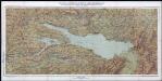
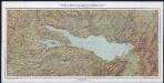
Karte von Bodensee, Rhein und Bregenzerwald : mit den angrenzenden Gebieten von Baden, Württemberg, Bayern, Österreich und der Schweiz
Becker, Fridolin Kümmerly und Frey