Maps of Namur
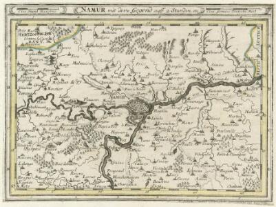
Namur mit dero Gegend auff 2 Stunden etc.
1 : 150000 Mollova mapová sbírka Bodenehr, Gabriel Bodenehr, Gabriel
Namur mit dero Gegend auf 2 Stunden, etc
1 : 160000 Bodenehr, Gabriel G. Bodenehr
Namen, belegert, en door accoort ingenomen
't Amsterdam : by Laurens Gunter
Plan parcellaire de la commune de Landenne : avec les mutations
1 : 5000 Royal Library of Belgium Map Room Popp, Philippe Christian (1805-1879) Popp, Philippe Christian (1805-1879)
Platte-grond van de stad en 't kasteel van Namen met syn buytewerken, batteryen, approches, tranchees, linien van circumvallatie en contrevallatie etc.
1 : 33000 t'Amsteldam : by Nicolaus Visscher
Plan parcellaire de la commune de Seilles : avec les mutations
1 : 5000 Royal Library of Belgium Map Room Popp, Philippe Christian (1805-1879) Popp, Philippe Christian (1805-1879)
Plan parcellaire de la commune de Bas-Oha : avec les mutations
1 : 5000 Royal Library of Belgium Map Room Popp, Philippe Christian (1805-1879) Popp, Philippe Christian (1805-1879)
Plan de la ville et citadelle de Namur
1 : 9500 Namur (Belgie) Mortier, Pieter Pierre Mortier
Namvrcvm, elegantissima ad Mosae flum.e civitas
Namur (Belgie)
NAMVRCVM
[Amsterdam : Joan Blaeu]
Plan parcellaire de la commune de Couthuin : avec les mutations
1 : 5000 Royal Library of Belgium Map Room Popp, Philippe Christian (1805-1879) Popp, Philippe Christian (1805-1879)
Plan parcellaire de la commune de Ben-Ahin : avec les mutations
1 : 5000 Royal Library of Belgium Map Room Popp, Philippe Christian (1805-1879) Popp, Philippe Christian (1805-1879)
Comte de Namur
1 : 250000 Mollova mapová sbírka Seutter, Matthäus Lotter, Tobias Conrad Seutter, Matthäus
Comitatus Namurci Tabula
Mollova mapová sbírka Wit, Frederik de Covens, Johannes I
Comté de Namur
1 : 116600 Mollova mapová sbírka Fricx, Eugène Henry Covens, Johannes I
Carte particuliere des environs de Namur, Huy, Dinant, Philippeville, etc.
1 : 116600 Mollova mapová sbírka Fricx, Eugène Henry Harrewyn, Jacques Fricx, Eugené Henry
[Carte particuliere des environs de Namur, Huy, Dinant, Philippeville, etc.]
Belgie Fricx, Eugene Henry chez Eugene Henry Fricx
Comitatus Namurci tabula
1 : 130000 Wit, Frederick de Frederico de Wit
Die Grafschafft Namur Nach dero Eigendlichen Lager
1 : 567000 Mollova mapová sbírka Bodenehr, Gabriel Bodenehr, Gabriel
COMITATUS NAMURCI Emendata Delineatio
1 : 120000 Belgie Visscher, Nicolaus per Nicolaum Visscher
Comté de Namur
1 : 115000 A Amsterdam : chez Cóvens et Mortier
Comitatus Namurci Emendata Delineatio
1 : 300000 Mollova mapová sbírka Visscher, Nicolaes Schenk, Peter II
Carte du Comté de Namvr
1 : 130000 Mollova mapová sbírka Fricx, Eugène Henry Homann, Johann Baptista - dědici
Comitatvs Namvr
1 : 100000 Fricx, Eugene Henry par Homaniannos Heredes
Huy mit der gegend auff 2 Stunden.
1 : 150000 Mollova mapová sbírka Bodenehr, Gabriel Bodenehr, Gabriel
Plan parcellaire de la commune de Wanze : avec les mutations
1 : 5000 Royal Library of Belgium Map Room Popp, Philippe Christian (1805-1879) Popp, Philippe Christian (1805-1879)
Plan parcellaire de la commune de Moha : avec les mutations
1 : 5000 Royal Library of Belgium Map Room Popp, Philippe Christian (1805-1879) Popp, Philippe Christian (1805-1879)
Plan parcellaire de la commune de Warêt l'Evêque : avec les mutations
1 : 5000 Royal Library of Belgium Map Room Popp, Philippe Christian (1805-1879) Popp, Philippe Christian (1805-1879)
Plan parcellaire de la commune de Héron : avec les mutations
1 : 5000 Royal Library of Belgium Map Room Popp, Philippe Christian (1805-1879) Popp, Philippe Christian (1805-1879)