Maps of Bad Cannstatt
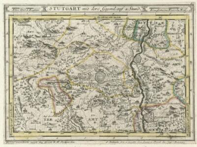
Stutgart, mit dero Gegend auf 2 Stund.
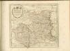
1 : 150000 Mollova mapová sbírka Bodenehr, Gabriel H., R.
Meßtischblatt [7220] : Möhringen, 1929
1 : 250000 Möhringen. - 2. Ausg. 1929. - 1:25000. - Stuttgart: Statistisches Landesamt, 1929. - 1 Kt.
Meßtischblatt [7220] : Möhringen, 1911
1 : 250000 Möhringen. - 1:25000. - Stuttgart, 1911. - 1 Kt.
Meßtischblatt [7220] : Möhringen, 1899
1 : 250000 Möhringen. - 1:25000. - Stuttgart, 1899. - 1 Kt.
Town Plan of Stuttgart, 1936 - sheet 2.
This map was copied from a 1936 German map and publiched by the British War Office in 1944. Scale 1 : 19,000. [G.S.G.S. No. 4480] Great Britain. War Office.
Meßtischblatt [7221] : Stuttgart, 1930
1 : 250000 Stuttgart. - 2. Ausg. - 1:25000. - Stuttgart, 1930. - 1 Kt.
Stuttgart

Germany [Town plans of], Stuttgart
Town plans of Germany, GSGS 4480. Great Britain. War Office. [London] : War Office
Plan der ersten Königl. Haupt und Residenz Stadt Stuttgart im Jahr 1811
Stuttgart (Německo) Waltter Ringlin, Johann G. in der J.G. Cotta'schen Buchhandlung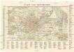
Plan von Stuttgart
1 : 12000 Stuttgart (Německo)
Stuttgart
Wagner
Plan Geometrique Et Perspective De La Ville Capitale De Stouttgard Dans Le Duchè De Wirttemberg
Riediger, Johann Adam
STUTGARDIA
Stuttgart (Německo) Seutter, Matthäus a M. Seutter
Stutgardia Würtenbergensis ducatia metropolis arcem habens elegantissimam, multas. amöenitates
Stuttgart (Německo) Seutter, Matthäus M. Seutter
Plan von STUTTGART
1 : 11200 Stuttgart (Německo)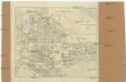
Plan von Stuttgart
1 : 12000 Stuttgart (Německo)
Plan oder Wegweiser von Stuttgart mit Bezeichnung der Viertel, Strassen und Hausnummern
1 : 5000 Stuttgart : G. Ebner'sche Kunsthandlung
Stuttgart

Plan von Hohenheim
Böhnen, L. v.; Abel, Gottlieb Friedrich
Karte der Umgegend von Stuttgart
1 : 70000 Stuttgart-oblast (Německo) Hoffmann, Carl Carl Hoffmann
Meßtischblatt 56 = [7120] : Leonberg, 1929
1 : 250000 Leonberg. - 2. Ausg. - 1:25000. - Stuttgart, 1929. - 1 Kt.
Meßtischblatt 56 = [7120] : Leonberg, 1896
1 : 250000 Leonberg. - 1:25000. - Stuttgart, 1896. - 1 Kt.
Meßtischblatt 57 = [7121] : Cannstatt (Stuttgart-Nordost), 1936
1 : 250000 Cannstatt (Stuttgart-Nordost). - Hrsg. (2. Ausg.) 1930, berichtigt 1933, einzelne Nachtr. bis 1936. - 1:25000. - Stuttgart, 1936. - 1 Kt.
Meßtischblatt 57 = [7121] : Cannstatt, 1930
1 : 250000 Cannstatt. - 2. Ausg. - 1:25000. - Stuttgart, 1930. - 1 Kt.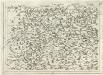
Geographica Provinciarum Sveviae Descriptio =
Mollova mapová sbírka Hurter, Johann Christoph Bodenehr, Johann Georg
170. Stuttgart, uit: Topographische Uebersichtskarte des Deutschen Reiches / herausgegeben v. d. Kartogr. Abt. d. Königl. Preuß. Landesaufnahme
1 : 200000 titelvariant: Topogr. Übersichtskarte des Deutschen Reiches; Annotatie: Titel boven bladen ook: Topogr. Übersichtskarte des Deutschen Reiches; Annotatie geografische gegevens: Op elk blad twee maatstokken: 10 Kilometer = 5,5 cm; 1 geogr. Meile = 3,6 cm; Legenda onder op elk blad Königlich Preußische Landesaufnahme. Kartographische Abtheilung [S.l : Königlich Preußische Landesaufnahme, Kartographische Abtheilung]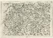
Geographica Provinciarum Sveviae Descriptio =
Mollova mapová sbírka Hurter, Johann Christoph Bodenehr, Gabriel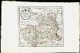
Des Herzogthums Würtemberg nordwestliche Aemter mit der freyen Reichsstadt Weil : Nro. 187
Reilly, Franz Johann Joseph von
Le Flambeau de la Guerre Allumee au Rhin
Mollova mapová sbírka Delisle, Guillaume Schenk, Peter II