Maps of Landkreis Neustadt an der Aisch-Bad Windsheim
Geographica Provinciarum Sveviae Descriptio =
Mollova mapová sbírka Hurter, Johann Christoph Bodenehr, Johann Georg
Geographica Provinciarum Sveviae Descriptio =
Mollova mapová sbírka Hurter, Johann Christoph Bodenehr, Gabriel
Principatus Brandenbvrgico Cvlmbacensis vel Barvthini
1 : 120000 Mollova mapová sbírka Cnopf, Matthäus Ferdinand Homann, Johann Baptista - dědici

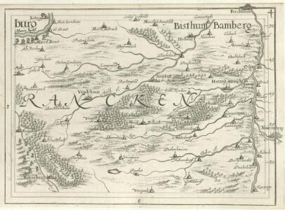
Windsheim
1 : 50000 Mollova mapová sbírka Homann, Johann Baptista - dědici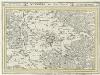
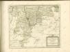
Nürnberg, mit dero Gegend.
1 : 100000 Mollova mapová sbírka Bodenehr, Gabriel Bodenehr, Gabriel
Decem et tria loca confoederatorvm Helvetiae
Schwyz (Švýcarsko) Braun, Georg Hogenberg, Franz
Nürnberg

Geometrischer Grundris der des Heiligen Romischen Reiches Freyen Stadt Nürnberg
Seutter, Matthaeus, 1678-1756 Matth. Seutter, Kayserl. Geogr.
[Nürnberg]
Paul, August August Paul
Grundris der Stadt Nürnberg
Mollova mapová sbírka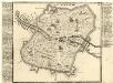
Nürnberg.
Mollova mapová sbírka Bodenehr, Gabriel Bodenehr, Gabriel
Nürmberg :
Mollova mapová sbírka Bodenehr, Gabriel Bodenehr, Gabriel
Prospect und Grundris der des Heil: Röm. Reichs-Stadt Nürnberg : samt ihren Linien und Gegend auf eine Meil-wegs herumb
Homann, Johann Baptist, 1663-1724 Ioh. Bap. Homann
Civitatis NORIMBERGAE
Norimberk (Německo) Hollar, Václav
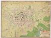
Plan von Nürnberg 1909
1 : 12500 Nuremberg (Germany). Stadtmagistrat Verlag des Stadtmagistrats Nürnberg
Prospect und Grundris der des Heil. Röm. Reichs-Stadt Nürnberg samt ihren Linien und Gegend auf eine Meil-wegs herumb
Norimberk (Německo) Homann, Johann Baptist Ioh. Bapt. Homann
Pharus-Plan Nürnberg
1 : 8400 Pharus-Verlag Pharus-Verlag
Tabulae Geographicae Principatus Brandenburg: Culmb: sive Baruthini Pars Inferior cum adjacentibus Regionibus exhibita et Sculpta
1 : 150000 Mollova mapová sbírka Seutter, Matthäus Seutter, Matthäus
Tabulae geographicae principatus Brandenburg. Culmb. sive Baruthini
1 : 179600 Bavorsko severní (Německo) Lotter, Tobias Conrad Tob. Conrad Lotter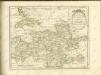

Mappa Geographica exhibens Principatvm Brandenbvrgico Onolsbacensem, una cum finitimis Regionibus Terrisque
1 : 260000 Mollova mapová sbírka Cnopf, Matthäus Ferdinand Hauer, Daniel Adam Homann, Johann Baptista - dědici
Carte topographique d'Allemagne contenant la Franconie sçavoir une partie des evechés de Wurzbourg de Bamberg
1 Karte : Kupferdruck ; 46 x 62 cm Jaeger; Facius se vend chés l'auteur
Tabula Geographica Nova exhibens Partem Infra Montanam Burggraviatus Norimbergensis Sive Principatum Onolsbacensem cum Terris Limitaneis Accurate delineatam
1 : 140000 Mollova mapová sbírka Vetter, Johann Georg Windter, Johann W. Vetter, Johann Georg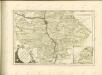

Deutsche Strassenprofilkarte für Rad - und Autofahrer 58 Nürnberg

153. Bamberg, uit: Topographische Uebersichtskarte des Deutschen Reiches / herausgegeben v. d. Kartogr. Abt. d. Königl. Preuß. Landesaufnahme
1 : 200000 titelvariant: Topogr. Übersichtskarte des Deutschen Reiches; Annotatie: Titel boven bladen ook: Topogr. Übersichtskarte des Deutschen Reiches; Annotatie geografische gegevens: Op elk blad twee maatstokken: 10 Kilometer = 5,5 cm; 1 geogr. Meile = 3,6 cm; Legenda onder op elk blad Königlich Preußische Landesaufnahme. Kartographische Abtheilung [S.l : Königlich Preußische Landesaufnahme, Kartographische Abtheilung]