Maps of Alb-Donau-Kreis
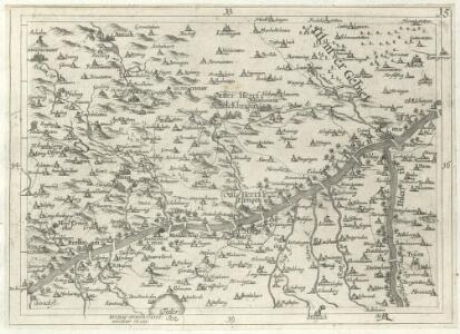
Geographica Provinciarum Sveviae Descriptio =
Mollova mapová sbírka Hurter, Johann Christoph Bodenehr, Johann Georg
Geographica Provinciarum Sveviae Descriptio =
Mollova mapová sbírka Hurter, Johann Christoph Bodenehr, Gabriel
Ulm mit der Gegend auf 1 1/4 Stund
Mollova mapová sbírka Bodenehr, Gabriel Bodenehr, Gabriel
Ehingen, Weissenhorn a okolí]
Mollova mapová sbírka Bodenehr, Gabriel Bodenehr, Gabriel
Abriss des Territorii Ulmensis Ultra-Danubialis, Sambt denen Beeden Wildpan. bezürcken
1 : 100000 Mollova mapová sbírka Mayer, Bartholomaeus Bodenehr, Gabriel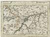
Ulm mit dero Gegend auf 2 Stund.
1 : 150000 Mollova mapová sbírka Bodenehr, Gabriel Bodenehr, Gabriel
Blatt 111: Urach, uit: Topographische Karte von Württemberg im Massstab 1:25.000 / hrsg. vom Statistischen Landesamt
1 : 25000 titelvariant: Topographische Karte des Königreichs Württemberg im Massstabe 1:25.000; Annotatie: Titelvariant: Topographische Karte des Königreichs Württemberg im Massstabe 1:25.000; Incompleet (4 bl. aanwezig) Württembergisches Statistisches Landesamt [Stuttgart : Statistisches Landesamt]
Meßtischblatt [7725] : Laupheim, 1915
1 : 250000 Laupheim. - 1:25000. - Stuttgart, 1915. - 1 Kt.
Meßtischblatt[7724] : Ehingen, 1913
1 : 250000 Ehingen. - 1:25000. - Stuttgart, 1913. - 1 Kt.
Meßtischblatt [7723] : Munderkingen, 1913
1 : 250000 Munderkingen. - 1:25000. - Stuttgart, 1913. - 1 Kt.
Meßtischblatt [7722] : Zwiefalten (Württ.). Kettenacker (Preuß.), 1912
1 : 250000 Zwiefalten (Württ.). Kettenacker (Preuß.). - 1:25000. - Stuttgart, 1912. - 1 Kt.
Meßtischblatt Ulm, 1909
1 : 250000 Ulm. - 1:25000. - Stuttgart, 1909. - 1 Kt.
Meßtischblatt [7624] : Schelklingen, 1912
1 : 250000 Schelklingen. - 1:25000. - Stuttgart, 1912. - 1 Kt.
Meßtischblatt [7623] : Mehrstetten, 1912
1 : 250000 Mehrstetten. - 1:25000. - Stuttgart, 1912. - 1 Kt.
Meßtischblatt [7622] : Buttenhausen, 1912
1 : 250000 Buttenhausen. - 1:25000. - Stuttgart, 1912. - 1 Kt.
Meßtischblatt [7525] : Bermaringen, 1926
1 : 250000 Bermaringen. - 1:25000. - Stuttgart, 1926. - 1 Kt.
Meßtischblatt [7525] : Bermaringen, 1909
1 : 250000 Bermaringen. - 1:25000. - Stuttgart, 1909. - 1 Kt.
Meßtischblatt [7524] : Blaubeuren, 1935
1 : 250000 Blaubeuren. - 1:25000. - Stuttgart, 1935. - 1 Kt.
Meßtischblatt [7523] : Böhringen, 1932
1 : 250000 Böhringen. - 2. Ausg. - 1:25000. - Stuttgart, 1932. - 1 Kt.
Meßtischblatt [7523] : Böhringen, Truppenübungsplatz Münsingen, 1901
1 : 250000 Böhringen, Truppenübungsplatz Münsingen. - 1:25000. - Stuttgart, 1901. - 1 Kt.
Meßtischblatt Urach, 1930
1 : 250000 Urach. - 1:25000. - Stuttgart, 1930. - 1 Kt.
Blatt 112: Böhringen, uit: Topographische Karte von Württemberg im Massstab 1:25.000 / hrsg. vom Statistischen Landesamt
1 : 25000 titelvariant: Topographische Karte des Königreichs Württemberg im Massstabe 1:25.000; Annotatie: Titelvariant: Topographische Karte des Königreichs Württemberg im Massstabe 1:25.000; Incompleet (4 bl. aanwezig) Württembergisches Statistisches Landesamt [Stuttgart : Statistisches Landesamt]
Accurater Grund-Riss sambt der Situation und Attaque des H. Röm. Reichs freyen und berühmten Stadt Ulm
Mollova mapová sbírka Bodenehr, Gabriel Bodenehr, Gabriel
Porostní mapa lesního majetku statku Oberstadion
1 : 10000
Germany [Town plans of], Ulm
Town plans of Germany, GSGS 4480. Great Britain. War Office. [London] : War Office
Přehledná mapa části lesního majetku panství Oberstadion-Emerkingen
1 : 5000
Meßtischblatt [7721] : Gammertingen (Preuß.) Mägerkingen (Württ.), 1910
1 : 250000 Gammertingen (Preuß.) Mägerkingen (Württ.). - 1:25000. - Stuttgart, 1910. - 1 Kt.
Meßtischblatt Trochtelfingen (Preuß.) Undingen (Württ.), 1910
1 : 250000 Trochtelfingen (Preuß.) Undingen (Württ.). - 1:25000. - Stuttgart, 1910. - 1 Kt.
Meßtischblatt 7521 : Reutlingen, 1936
1 : 250000 Reutlingen. - Aufn. 1871/1903, hrsg. 1908, bericht. 1936. - 1:25000. - Stuttgart, 1936. - 1 Kt.
Meßtischblatt [7521] : Reutlingen, 1915
1 : 250000 Reutlingen. - Hrsg. 1908, 2. Ausg. 1915. - 1:25000. - Stuttgart, 1915. - 1 Kt.
Meßtischblatt [7521] : Reutlingen, 1910
1 : 250000 Reutlingen. - 1:25000. - Stuttgart, 1910. - 1 Kt.