Maps of Aargau
Geographica Provinciarum Sveviae Descriptio =
Mollova mapová sbírka Hurter, Johann Christoph Bodenehr, Johann Georg
<<Der>> Canton Aargau
1 : 230000 1 Karte gez. u. gest. v. J.J. Scheurmann Orell, Füssli & Cp., Zürich
<<Der>> Canton Aargau
1 : 230000 1 Karte gez. u. gest. v. J.J. Scheurmann Orell, Füssli & Cp., Zürich
Nivellements-Karte des Cantons Aargau
1 : 125000 Michaelis, Ernst Heinrich [Aargauische Militär-Kommission]
<<Der>> Canton Aargau
1 : 230000 1 Karte gez. u. gest. von J.J. Scheurmann Orell Füssli & Cp., Zürich
Topographische Karte der Schweiz (Dufour-Karte), Kartenzusammensetzungen: Den Kanton Zürich betreffende Blätter: Aarau
Eidgenössische Landestopographie, in Köniz-Wabern
Kanton Aargau: Trigonometrisches Netz
1 : 125000 Ohne Datumsangabe.
Kanton Aargau: Trigonometrisches Netz
Benz, Joh., Ingenieur
<<Der>> Canton Aargau
1 : 230000 1 Karte gez. u. gest. von J.J. Scheurmann [Orell Füssli & Cp.], [Zürich]
Trigonometisches Netz zur topographischen Karte des Cantons Aargau
1 : 125000 None
Atlas de la Suisse
1 : 450000 1 Atlas (19 Bl.) dessiné par MM. H. Keller, Scheurmann, Pfyffer d'Altishofen, Osterwald, etc. ; gravé par M. Scheurmann Orell Füssli & Co., Zürich
Atlas der Schweiz
1 : 450000 1 Atlas (18 Bl.) gez. u. gest. v. J. Scheurmann Orell Fussli, Zurich
Carte von dem Canton Argau
1 Karte : Kupferdruck ; 42 x 48 cm Scheurmann zu haben bey J. Scheurmann Kupferstecher in Arau no. 252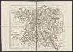
Canton Aargau
1 : 230000 Scheuermann, Johann Jakob Orell, Füssli & Cp.
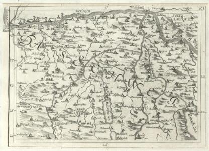
Geographica Provinciarum Sveviae Descriptio =
Mollova mapová sbírka Hurter, Johann Christoph Bodenehr, Gabriel
Taschen-Atlas der Schweiz
1 Atlas (25 S., 20 Taf.) gezeichnet und gestochen von Emil Wagner = Atlas de poche de la Suisse : 26 cartes en couleurs / dessinées et gravées par Émile Wagner Eggimann, Genf
Carte von dem Canton Aargau
1 : 120000 Scheuermann, Johann Jakob Scheurmann
Karte des Kantons Aargau
1 : 200000 1 Karte von J.S. Gerster Wurster, Randegger & Cie., Winterthur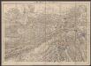
Solothurn - Basel - Brugg
1 : 100000 Kriegsdepot des Eidg. Topographischen Bureau's
Nova descriptio ditionis Tigurinae regionumque finitimarum
1 : 95000 1 Karte auf 6 Bl. Joh. Conradus Gygerus, P. delineavit ; Joh. Georgius Gygerus, F. in aes incidi ; curavit per Johannem Meyerum Ao. 1685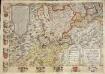
Inclitae Bernatum urbis, cum omni ditionis suae agro et provinciis delineatio chorographica, 13/14
2 Blätter : Adelbert Saueracher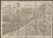
Solothurn - Basel - Brugg
1 : 100000 Kriegsdepot des Eidg. Topographischen Bureau's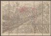
Solothurn - Basel - Brugg
1 : 100000 Kriegsdepot des Eidg. Topographischen Bureau's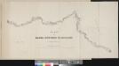
Plan der Basel-Zürcher-Eisenbahn
1 : 80000 1 Karte graviert von J. Drescher Orell Füssli, Zürich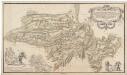
Neu festgesetzte Grenzen anlässlich des aargauischen Friedens im Jahre 1712 betreffend die Gebiete des Freiamtes, Oberlunkhofen bis Fahrwangen, Merenschwand, Schongau, Kelleramt, Niederamt, Grafschaft Baden, Eigenamt, Königsfelden und Lenzburg; Übersichtsplan
Rüdiger, Johann Adam, Ingenieur
Nova descriptio ditionis Tigurinae regionumque finitimarum
1 : 95000 1 Karte auf 6 Bl. Joh. Conradus Gygerus, P. delineavit ; Joh. Georgius Gygerus, F. in aes incidi ; curavit per Johannem Meyerum Ao. 1685
Eigentliche Verzeichnuss der Stätten, Graffschaften und Herrschaften, welche in der Statt Zürich Gebiet und Landschaft gehörig sind
1 : 56000 1 Karte auf 16 Bl. gerissen durch Josen Murern
Eigentliche Verzeichnuss der Städten, und Graffschaften und Herrschaften, welche in der Stadt Zürich-Gebiet und Landschaft gehörig sind
1 : 56000 1 Karte auf 16 Bl. gerissen durch Josen Murern
[Eigentliche Verzeichnung der Städten, und Graffschaften, und Herrschaften, welche in der Stadt Zürich Gebiet und Landschaft gehörig sind]
1 : 56000 1 Karte auf 6 Bl. [gerissen durch Josen Murer]