Maps of Lübeck

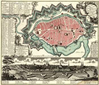
Grund-Riß der Kayserlichen und des Heil. Röm. Reichs Freyen Stadt Lübeck
1 : 5400 Mollova mapová sbírka Seutter, Matthäus Seutter, Matthäus
Plan der Stadt Lübeck: neu berichtigt und herausge
Saltzenberg, J. F.
Meßtischblatt 2130 : Lübeck, 1941
1 : 250000 Lübeck. - Hrsg. 1879, bericht. 1920. - 1:25000. - [Berlin]: Reichsamt für Landesaufnahme, 1941. - 1 Kt.
Meßtischblatt 747 : Lübeck, 1920
1 : 250000 Lübeck. - Aufn. 1877, bericht. 1920. - 1:25000. - [Berlin]: Reichsamt für Landesaufnahme, 1920. - 1 Kt.
Meßtischblatt 747 : Lübeck, 1914
1 : 250000 Lübeck. - Aufn. 1877, hrsg. 1879, Aufldr. 1914. - 1:25000. - [Berlin]: Reichsamt für Landesaufnahme, 1914. - 1 Kt.
Composite: 114. Lubeck. (Germany)
1 : 100000 Reichsamt fur Landesaufnahme
114. Lubeck. (Germany)
1 : 100000 Reichsamt fur Landesaufnahme

41. Lübeck, uit: Topographische Uebersichtskarte des Deutschen Reiches / herausgegeben v. d. Kartogr. Abt. d. Königl. Preuß. Landesaufnahme
1 : 200000 titelvariant: Topogr. Übersichtskarte des Deutschen Reiches; Annotatie: Titel boven bladen ook: Topogr. Übersichtskarte des Deutschen Reiches; Annotatie geografische gegevens: Op elk blad twee maatstokken: 10 Kilometer = 5,5 cm; 1 geogr. Meile = 3,6 cm; Legenda onder op elk blad Königlich Preußische Landesaufnahme. Kartographische Abtheilung [S.l : Königlich Preußische Landesaufnahme, Kartographische Abtheilung]
146. Hamburg. (Germany)
1 : 100000 Reichsamt fur Landesaufnahme
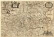
PARS MERIDIONALIS | WAGRIÆ, | cum partes | STORMARIÆ | in qua Episcopatus Lubencensis, | Plona Principatus, et Præfectura | Segebergensis
Andres Lorensen | Rothgiesser Hus. | sculps. [Amsterdam : Joan Blaeu]
Wagria quae est Pars Orientalis Holsatiae
1 : 190000 Mollova mapová sbírka Janssonius, Johannes Schenk, Peter I
Landtcarte Uom Süderntheil des Wagerland's
1 : 130000 Mollova mapová sbírka Mejer, Johannes Rothgiesser, Andreas Lorenzen
Wagria, quae est Pars Orientalis Holsatiae. [Karte], in: Novus atlas absolutissimus, Bd. 1, S. 149.
1 Karte aus Atlas Janssonius Offizin
WAGRIA, | que est | PARS ORIENTALIS | HOLSATIÆ.
Matthias & Nicolaus Peters | Goltschmide gebr. Hus. sculpst. [Amsterdam : Joan Blaeu]
Tabula geographica novissima ducatus Stormariae in meridionali parte Holsatiae
1 : 209000 Holštýnsko Schenk, Pieter Valk, Gerhard apud P. Schenk et G. Valk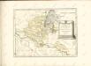

STORMARIA | DVCATVS
Auctore Joh: Meyer Husumensi. Matthias & Nicolaus Peters | Goldtschmide gebr. Hus. sculp. [Amsterdam : Joan Blaeu]
Hamburg 33, uit: Special-Karte von Mittel-Europa / nach amtlichen Quellen bearbeitet von W. Liebenow
1 : 300000 titelvariant: W. Liebenow's Mittel-Europa; Annotatie: Titel boven de bladen: W. Liebenow's Mittel-Europa Johannes Wilhelm Liebenow 1822-1897 Frankfurt a. M. : Ludwig Ravenstein
Typus Geographicus Ducat. Lauenburgici Novus
1 : 270000 Mollova mapová sbírka Homann, Johann Christoph Schneider, Ruprecht Adam Homann, Johann Baptista - dědici
Tabula Geographica novissima Ducatus Stormariae, in Meridionali parte Holsatiae. [Karte], in: Novus atlas absolutissimus, Bd. 1, S. 152.
1 Karte aus Atlas Janssonius Offizin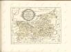


[Herzogthum Holstein und Lauenburg, Fürstenthum Lübeck, Fr. Städte Hamburg und Lübeck nebst Amt Bergedorf]
Grosser Hand-Atlas über alle Theile der Erde in 170 Karten Meyer, J. Verlag des Bibliographischen Instituts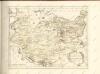

Holstein, Lauenburg, Lubeck, Hamburg.
1 : 440000 Meyer, Joseph, 1796-1856
Holstein, Lauenburg, Hamburg, Lubeck.
1 : 435000 Flemming, Carl
Tabvla Generalis Holsatiae complectens Holsatiae Dithmarsiae Stormariae et Vagriae Dvcatvs
1 : 310000 Mollova mapová sbírka Homann, Johann Baptist Homann, Johann Baptista