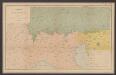
Maps of West Flanders

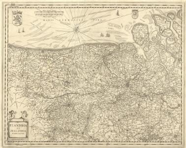
Flandria et Zeelandia Comitatvs
1 : 266000 Mollova mapová sbírka Blaeu, Willem Janszoon Blaeu, Willem Jansz.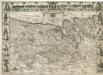
Comitatus Flandria
1 : 440000 Mollova mapová sbírka Visscher, Claes Jansz. Visscher, Claes Janszoon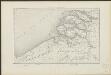
Carte des bouches de l'Escaut
1 : 500000 dressée par Th. Duvotenay gravée par Ch. Dyonnet. Paris : Lheureux et Cie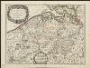
Flandre Espagnole, et Flandre Hollandoise
1 : 250000 dressée sur les Memoires les plus nouveaux par le Sr. Sanson A Paris : chez H. Jaillot, joignant les grands Augustins aux 2 globes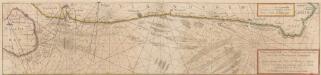
Pascaert vande Custe van Vlaenderen, van Walcheren tot Cales en Bouloigne im Vranckrijck. [Karte, Küste] , in: Novus atlas absolutissimus, Bd. 3, S. 112.
1 Karte aus Atlas Janssonius Offizin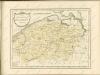

EPISCOPATVS | GANDAVENSIS
Iohannes et Cornelius Blaeu | Excudebant
Flandre Espagnole et Flandre Hollandoise
1 : 266000 Mollova mapová sbírka Sanson, Nicolas Jaillot, Alexis Hubert
[13], uit: Hydro-Oro und Chorographische General Karte des Koenigreichs der Niederlande und der angrenzenden Länder bis Paris : mit der Angabe der Kunst und Heer-Strassen und der Entfernung der Poststationen / ... zusammengetragen und reducirt von ... Wilhelm Müller
1 : 400000 titelvariant: Generalkarte des Koenigreichs Hannover; Annotatie: 1e supplement bij: Generalkarte des Koenigreichs Hannover (1818) Müller, Wilhelm (fl. 1818) [Hannover : Wilhelm Müller]
Neuer Plan von den Lauf der Schiffbaren Schelde von Antwerpen durch Holländisch Seeland, bis zu deren Mündung an der Nord-See
1 : 550000 I. Berlia sc. Prag : aus der von Schönfeldischen Officin
Abris der Schelde, soweit sie schiffbar ist, von Antwerpen bis an die Nord-See
1 : 550000 Math. Pock geometra sc. Salisburgi. Salzburg : Lor. Hübner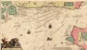
Pascaart Vande Zeeuse Vlaemse en Engelse Kusten
Mollova mapová sbírka Keulen, Johannes van Keulen, Johann
Zeeland
1 : 790000 P.H. Witkamp del. D. Veelwaard sculps. Amsterdam : C.L. Brinkman exc.
FLANDRIÆ | TEVTONICÆ | PARS ORIENTALIOR
Guilielmus et Iohannes Blaeuw exc. Amsterdami
Episcopatvs Gandavensis
1 : 190000 Mollova mapová sbírka Blaeu, Joan Blaeu, Cornelis
Habes hic Novam & accuratißimam descriptionem tractus illius Flandriae [...] [Belgien, Flandern] [Karte], in: Gerardi Mercatoris Atlas, sive, Cosmographicae meditationes de fabrica mundi et fabricati figura, S. 293.
1 Karte aus Atlas Mercator, Gerhard Montanus, Petrus
Pars Flandriae orientalis; Franconatum, insulam Causant etc. Civitatesque Gaudavum, Brugas, [...] [Karte], in: Gerardi Mercatoris et I. Hondii Newer Atlas, oder, Grosses Weltbuch, Bd. 1, S. 422.
1 Karte aus Atlas Mercator, Gerhard und Hondius, Jodocus Jansson, Jan
Pars Flandriae orientalis; Franconatum, insulam Causant etc. Civitatesque Gaudavum, Brugas, [...] [Karte], in: Novus atlas absolutissimus, Bd. 3, S. 121.
1 Karte aus Atlas Janssonius Offizin
Flandriae Teutonicae Pars Orientalior [Karte], in: Le théâtre du monde, ou, Nouvel atlas contenant les chartes et descriptions de tous les païs de la terre, Bd. 1, S. 394.
1 Karte aus Atlas Blaeu, Willem Janszoon und Blaeu, Joan Blaeu, Willem Janszoon
Flandriae Teutonicae Pars Orientalior [Karte], in: Novus Atlas, das ist, Weltbeschreibung, Bd. 1, S. 357.
1 Karte aus Atlas Blaeu, Joan Blaeu, Willem Janszoon
[107][110] Pars Flandriae orientalis ..., uit: Atlas sive Descriptio terrarum orbis
Annotatie: Gedigitaliseerde versie. Amsterdam. Heiloo : Picturae (vervaardiger), 2015. tiff-bestand. Gedigitaliseerd: 07-01-2015; Origineel: Universiteitsbibliotheek Vrije Universiteit (XL.05127.-) ; Netherlands; Titelpagina ontbreekt Wit, Frederik de Amsterdam : Frederick de Wit
Flandriae Teutonicae Pars Orientalior [Karte], in: Theatrum orbis terrarum, sive, Atlas novus, Bd. 1, S. 370.
1 Karte aus Atlas Blaeu, Joan Blaeu, Willem Janszoon
Flandriae tevtonicae pars orientalior
1 : 190000 Flandry Blaeu, Joan Guiljelmus et Iohannes Blaeuw exc.
FRANCONATVS, | Vulgo | HET VRYE
Guilielmus et Iohannes Blaeuw exc. Amsterdami
Carte Contenant le Pais entre Nieuport l'Ecluse Anvers Ypres et Bruxelles
1 : 200000 Mollova mapová sbírka Le Rouge, Georges-Louis Le Rouge, Georges-Louis
Flandriae comitatus pars Batava tam in ejusdem subjacentia quam vicina territoria
1 : 150000 accuratissima divisa per Nicolaum Visscher Amst. Bat. [Amsterdam] : nunc apud Petrum Schenk Iunior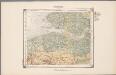
21. Walcheren, uit: Geologische kaart van Nederland / door W.C.H. Staring ; bew. aan de Topographische Inrichting
1 : 200000 Winand Carel Hugo Staring 1808-1877; Topographische Inrichting, 's-Gravenhage 's-Gravenhage : Belinfante
[Carte de la Belgique]
1 : 160000 Belgie Institut cartographique militaire
Flandriae Partes duae, quarum altera Proprietaria, altera Imperialis vulgo dicitur. [Karte], in: Novus atlas absolutissimus, Bd. 3, S. 132.
1 Karte aus Atlas Janssonius Offizin