Maps of Liège

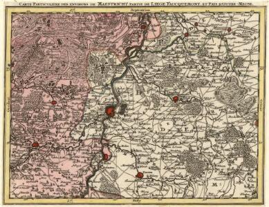
Carte Particuliere des Environs de Maestricht, Partie de Liege Faucquemont, et Pays d'Outre-Meuse
1 : 250000 Mollova mapová sbírka Seutter, Matthäus Lotter, Tobias Conrad Seutter, Matthäus
Limburgi Ducatus et Comitatus Valckenburgi Nova Descriptio [Karte], in: Novus atlas absolutissimus, Bd. 3, S. 70.
1 Karte aus Atlas Janssonius Offizin
Limburgi Ducatus et Comitatus Valckenburgi nova descriptio / per N. Visscher
1 : 110000 Annotatie: Origineel is Blad 38 in atlas factice; Annotatie geografische gegevens: Noordwest boven; Met 2 schaalstokken Nicolaes Jansz Visscher sr 1618-1679 [Amsterdam : N. Visscher]
[114][117] Tabula Ducatus Limburch. et Comitatus Valckenburgh., uit: Atlas sive Descriptio terrarum orbis
Annotatie: Gedigitaliseerde versie. Amsterdam. Heiloo : Picturae (vervaardiger), 2015. tiff-bestand. Gedigitaliseerd: 07-01-2015; Origineel: Universiteitsbibliotheek Vrije Universiteit (XL.05127.-) ; Netherlands; Titelpagina ontbreekt Wit, Frederik de Amsterdam : Frederick de Wit
Tabula Ducatus Limburch, et Comitatus Valckenburch
1 : 125000 in lucem edita a F. De Wit. Amsterdam : by I. Cóvens en C. Mortier
Carte Particuliere des Environs de Liege, Limbourg, et Partie de Luxembourg
1 : 250000 Mollova mapová sbírka Seutter, Matthäus Lotter, Tobias Conrad Seutter, Matthäus
Limburgi Ducatus et Comitatus Valckenburgi Nova Descriptio
1 : 110000 Mollova mapová sbírka Visscher, Nicolaes Schenk, Peter II
Tabula Ducatus Limburch et Comitatus Valckenburch in Lucem edita
1 : 120000 Mollova mapová sbírka Wit, Frederik de Wit, Frederick
Carte particuliere des environs de Maestricht, partie de Liege, Faucquemont, et Pays d'Outre-Meuse
1 : 110000 Belgie Fricx, Eugene Henry Harrewyn, Jacques chez Eugene Henry Fricx
Das Herzogthum Limburg
1 : 380000 Limbursko Schreiber, Johann Georg bey Joh. Georg. Schreibern
Carte Particuliere des environs de Maestricht Partie de Liege, Faucquemont, et Pays d'Outre-Meuse
1 : 116600 Mollova mapová sbírka Fricx, Eugène Henry Harrewyn, Jacques Fricx, Eugené Henry
Carte particuliere des environs de Liege, Limbourg, et partie de Luxembourg
1 : 110000 Belgie Fricx, Eugene Henry Harrewyn, Jacques chez Eugene Henry Friex
Dvcatvs Limbvrgvm
1 : 180000 Mollova mapová sbírka Martini, Aegidius Schenk, Peter I
Dvcatvs Limbvrgvm
1 : 266000 Mollova mapová sbírka Merian, Matthaeus Merian, Matthäus
Dvcatvs Limbvrgvm
1 : 180000 Mollova mapová sbírka Martini, Aegidius Blaeu, Joan I.
Dvcatvs Limbvrgvm
1 : 175000 Mollova mapová sbírka Martini, Aegidius
Carte particuliere des environs de Maestricht, partie de Liege faucquemont, et Pays d'Outre-Meuse
1 : 116600 Mollova mapová sbírka Fricx, Eugène Henry Covens, Johannes I
De klassis van Maastricht en landen van Overmaas
1 : 180000 door W.A. Bachiene ... J. van Jagen sculp. 1768. te Amsterdam : by D. onder de Linden
Carte du Marquisat de Franchimont
1 : 140000 H. Godin sculp. [S.l.] : [s.n.]
Carte Particuliere des environs de Liege, Limbourg, et Partie de Luxembourg
1 : 116600 Mollova mapová sbírka Fricx, Eugène Henry Covens, Johannes I
LIMBURGI Ducatus et Comitatus Nova Descriptio
1 : 110000 Limburg (Belgie : provincie) Visscher, Nicolaus per N. Visscher
Nieuwe en naauwkeurige kaart van de drie landen van Overmaaze, Valkenburg, Daalhem en 's Hertogenrade
1 : 200000 J. Keyser schulp. 1739. te Amsterdam : by Isaak Tirion
Carte particuliere des environs de Liege, Limbourg, et Partie de Luxembourg
1 : 116600 Mollova mapová sbírka Fricx, Eugène Henry Harrewyn, Jacques Fricx, Eugené Henry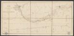
Plan du chemin de fer compris entre Liège et Aix-la-Chapelle
1 : 100000 Etablissement géographique
Tabula ducatus Limburch et comitatus Valckenburch
1 : 115000 Limbursko Wit, Frederick de by Frederick de Wit

Carte du marquisat de Franchimont
1 : 40000 Banneux (Belgie) Houdin, G.
Bl. 35 Maastricht, 1904, uit: Atlas A.N.W.B.
1 : 200000 titelvariant: Atlas van Nederland van den A.N.W.B. Toeristenbond voor Nederland; Wielrijders-atlas van Nederland; Annotatie: Titel op bladwijzer: Atlas van Nederland van den A.N.W.B. Toeristenbond voor Nederland; Titel op legendablad: Wielrijders-atlas van Nederland; Voor aanwezige bladen zie overzichtsblad; Annotatie geografische gegevens: De serie bestaat uit 36 bladen ANWB ['s-Gravenhage : A.N.W.B.]