Maps of Antwerp

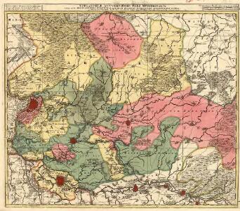
Tetrarchiae Antverpiensis pars meridionalis
1 : 133000 Mollova mapová sbírka Visscher, Nicolaes Schenk, Peter II

Carte Particuliere des Environs de Lier et d'une Partie de la Campine
1 : 250000 Mollova mapová sbírka Seutter, Matthäus Lotter, Tobias Conrad Seutter, Matthäus
Carte Particuliere des environs de Lier et d'un partie de la Campine
1 : 116600 Mollova mapová sbírka Fricx, Eugène Henry Covens, Johannes I
Carte particuliere des Environs de Lier et d'une Partie de la Campine
1 : 116600 Mollova mapová sbírka Fricx, Eugène Henry Fricx, Eugené Henry
Carte particuliere des environs de Lier et d'une partie de la Campine
1 : 110000 Belgie Fricx, Eugene Henry chez Eugene Henry Friex
Mechlinia Doninivm et Aerschot Dvcatvs
1 : 140000 Mollova mapová sbírka Langren, Michael Florent van Janssonius, Johannes I
Carte particuliere des environs d'une partie du comté de Hoogstraten
1 : 163000 Turnhout (Belgie) Covens & Mortier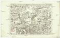
Carte particuliere des environs d'Herentals Aerschot et Diest
1 : 163000 Aarschot (Belgie) Covens & Mortier
Bl. 31 Chaam, 1905, uit: Atlas A.N.W.B.
1 : 200000 titelvariant: Atlas van Nederland van den A.N.W.B. Toeristenbond voor Nederland; Wielrijders-atlas van Nederland; Annotatie: Titel op bladwijzer: Atlas van Nederland van den A.N.W.B. Toeristenbond voor Nederland; Titel op legendablad: Wielrijders-atlas van Nederland; Voor aanwezige bladen zie overzichtsblad; Annotatie geografische gegevens: De serie bestaat uit 36 bladen ANWB ['s-Gravenhage : A.N.W.B.]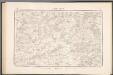
56 Herenthals, uit: Topographische en militaire kaart van het Koningrijk der Nederlanden / vervaardigd door de officieren van den Generale Staf ; en gegraveerd op het Topographisch Bureau, van het Ministerie van Oorlog
1 : 50000 titelvariant: TMK; Annotatie: Met bladwijzer op schaal 1:600.000. - 1915; Met Verklaring van de topographische en militaire kaart van het Koninkrijk der Nederlanden. - 1910; Bd. 1: titelblad, bladwijzer, verklaring, bladen 1 t/m 32; Bd. 2: bladen 33 t/m 62 Generale Staf, Nederland; Ministerie van Oorlog. Topographisch Bureau ['s-Gravenhage : Ministerie van Oorlog]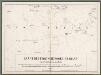
X, uit: Kaart der provincie Noord-Braband : volgens de opmetingen van het kadaster / vervaardigd onder leiding van L. van der Voordt Pieck en M. Kuijl ; getek. door A.B. van Lieshout ; op steen gegrav. door F. Desterbecq ; berekend met betrekking tot de driehoeksmeting door P.E. Fritsen en J. Kuijpers
1 : 50000 titelvariant: Kaart van Noord-Braband; Annotatie: Omslagtitel: Kaart van Noord-Braband; Met opdracht aan de Staten van Noord-Brabant L. van der Voordt Pieck; M. Kuijl; A.B. van Lieshout; François Desterbecq 1807-1896; Fritsen, P.E.; Kuijpers, J. [S.l. : s.n.]
Plan parcellaire de la commune de Brecht : avec les mutations
1 : 7500 Royal Library of Belgium Map Room Popp, Philippe Christian (1805-1879) Popp, Philippe Christian (1805-1879)
Plan parcellaire de la commune de Heyst-op-den-Berg : avec les mutations
1 : 5000 Royal Library of Belgium Map Room Popp, Philippe Christian (1805-1879) Popp, Philippe Christian (1805-1879)
Plan parcellaire de la commune de Schaffen : avec les mutations
1 : 5000 Royal Library of Belgium Map Room Popp, Philippe Christian (1805-1879) Popp, Philippe Christian (1805-1879)
Plan parcellaire de la commune de Berlaer lez-Lierre : avec les mutations
1 : 5000 Royal Library of Belgium Map Room Popp, Philippe Christian (1805-1879) Popp, Philippe Christian (1805-1879)
Plan parcellaire de la commune de Lierre : avec les mutations
1 : 5000 Royal Library of Belgium Map Room Popp, Philippe Christian (1805-1879) Popp, Philippe Christian (1805-1879)
Plan parcellaire de la commune de Schooten : avec les mutations
1 : 5000 Royal Library of Belgium Map Room Popp, Philippe Christian (1805-1879) Popp, Philippe Christian (1805-1879)
Plan parcellaire de la commune de Putte : avec les mutations
1 : 5000 Royal Library of Belgium Map Room Popp, Philippe Christian (1805-1879) Popp, Philippe Christian (1805-1879)
Plan parcellaire de la commune de Wavre-Ste-Catherine : avec les mutations
1 : 5000 Royal Library of Belgium Map Room Popp, Philippe Christian (1805-1879) Popp, Philippe Christian (1805-1879)
Plan parcellaire de la commune de Sichem lez-Diest : avec les mutations
1 : 5000 Royal Library of Belgium Map Room Popp, Philippe Christian (1805-1879) Popp, Philippe Christian (1805-1879)
Plan parcellaire de la commune de Rymenam : avec les mutations
1 : 5000 Royal Library of Belgium Map Room Popp, Philippe Christian (1805-1879) Popp, Philippe Christian (1805-1879)
Plan parcellaire de la commune de Itegem : avec les mutations
1 : 5000 Royal Library of Belgium Map Room Popp, Philippe Christian (1805-1879) Popp, Philippe Christian (1805-1879)
Plan parcellaire de la commune de 's Graven-Wesel : avec les mutations
1 : 5000 Royal Library of Belgium Map Room Popp, Philippe Christian (1805-1879) Popp, Philippe Christian (1805-1879)
Plan parcellaire de la commune de Bouchout (lez Lierre) : avec les mutations
1 : 5000 Royal Library of Belgium Map Room Popp, Philippe Christian (1805-1879) Popp, Philippe Christian (1805-1879)
Plan parcellaire de la commune de Duffel : avec les mutations
1 : 5000 Royal Library of Belgium Map Room Popp, Philippe Christian (1805-1879) Popp, Philippe Christian (1805-1879)
Plan parcellaire de la commune de Nylen : avec les mutations
1 : 5000 Royal Library of Belgium Map Room Popp, Philippe Christian (1805-1879) Popp, Philippe Christian (1805-1879)
Plan parcellaire de la commune de Bonheyden : avec les mutations
1 : 5000 Royal Library of Belgium Map Room Popp, Philippe Christian (1805-1879) Popp, Philippe Christian (1805-1879)