Maps of Oostende

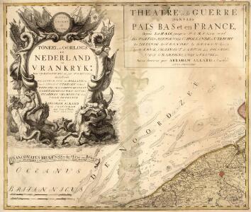
Theatre de La Guerre dans les Pais Bas et en France, Depuis La Haie jusqu'a Partis; ousont. Les Partis Meridionales d'Hollande et d'Utrecht La Zeelande La Flandre Le Brabant - Le Namur, L'Hainaut L'Artois, La Picardie, La Champagne, L'Isle de France :
1 : 250000 Mollova mapová sbírka Allard, Abraham Allart, Abraham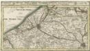
Brugge, Gent, Damme, Oostende, Schluys und andere Nah an liegende Staette Plaetze und Vestungen mitt deren Gegenden
1 : 250000 Mollova mapová sbírka Bodenehr, Gabriel Bodenehr, Gabriel
Carte Particuliere des Environs de Bruges, Ostende, Damme, l'Ecluse et Autres
1 : 250000 Mollova mapová sbírka Seutter, Matthäus Lotter, Tobias Conrad Seutter, Matthäus
Le Theatre de Bellone :
Mollova mapová sbírka Schenk, Pieter Braakman, Adriaan
Carte particuliere des environs de Bruges, Ostende, Damme, l'Ecluse et autres
1 : 110000 Belgie Fricx, Eugene Henry Harrewyn, Jacques chez Eugene Henry Fricx
Carte Particuliere des environs de Bruges, Ostende, Damme, l'Ecluse et autres
1 : 116600 Mollova mapová sbírka Fricx, Eugène Henry Covens, Johannes I
Carte particuliere des Environs de Bruges, Ostende, Damme, l'Ecluse et Autres
1 : 116600 Mollova mapová sbírka Fricx, Eugène Henry Harrewyn, Jacques Fricx, Eugené Henry
Ostende. Grid maps with 'Revised system of squaring' in top margin
1 : 40000 First World War map of Ostende. Grid maps with 'Revised system of squaring' in top margin. Improved squaring for artillery. War Office
53 Sluis, uit: Topographische en militaire kaart van het Koningrijk der Nederlanden / vervaardigd door de officieren van den Generale Staf ; en gegraveerd op het Topographisch Bureau, van het Ministerie van Oorlog
1 : 50000 titelvariant: TMK; Annotatie: Met bladwijzer op schaal 1:600.000. - 1915; Met Verklaring van de topographische en militaire kaart van het Koninkrijk der Nederlanden. - 1910; Bd. 1: titelblad, bladwijzer, verklaring, bladen 1 t/m 32; Bd. 2: bladen 33 t/m 62 Generale Staf, Nederland; Ministerie van Oorlog. Topographisch Bureau ['s-Gravenhage : Ministerie van Oorlog]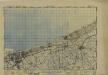
France 1:50,000, Dunkerque
Sheet 29 from the 115-sheet map series: France and Belgium 1 : 50,000. G.S.G.S. No. 4040. Compiled and drawn by O.S. Revised 1939-44. [London] : War Office
TABVLA PRÆLII PROPE NEOPORTVM COMMISSI II IVLII MDC. | inter Exercitus Alberti Archiduci Austriæ, etc. DD Ordinum Foederatæ Belgicæ ductu Principis Maurity Comitis Naßoviæ, etc.
Battle plan in two sections. [Amsterdam : Joan Blaeu]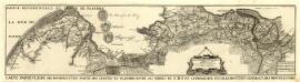
Carte Particuliere des Environs d'une Partie des Limites en Flandre :
1 : 80000 Mollova mapová sbírka Suly, Nicolas Scheurleer, Hendrik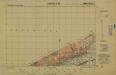
France and Belgium 1:25,000, Dunkerque, NE
This is sheet 29NE of the map series France and Belgium 1:25,000 , Series GSGS 4041, which covers the whole of Belgium, plus the north-east of France, in a total of 818 sheets. Great Britain. War Office. General Staff. Geographical Section. [S.l.] : [GSGS, War Office]
Plan parcellaire de la commune de Oostcamp : avec les mutations
1 : 7500 Royal Library of Belgium Map Room Popp, Philippe Christian (1805-1879) Popp, Philippe Christian (1805-1879)
Plan parcellaire de la commune de Beernem : avec les mutations
1 : 5000 Royal Library of Belgium Map Room Popp, Philippe Christian (1805-1879) Popp, Philippe Christian (1805-1879)
Plan parcellaire de la commune de Dudzeele : avec les mutations
1 : 5000 Royal Library of Belgium Map Room Popp, Philippe Christian (1805-1879) Popp, Philippe Christian (1805-1879)
Plan parcellaire de la commune de Leffinghe : avec les mutations
1 : 5000 Royal Library of Belgium Map Room Popp, Philippe Christian (1805-1879) Popp, Philippe Christian (1805-1879)
Plan parcellaire de la commune de Lisseweghe : avec les mutations
1 : 5000 Royal Library of Belgium Map Room Popp, Philippe Christian (1805-1879) Popp, Philippe Christian (1805-1879)
Plan parcellaire de la commune de Zedelghem : avec les mutations
1 : 7500 Royal Library of Belgium Map Room Popp, Philippe Christian (1805-1879) Popp, Philippe Christian (1805-1879)
Plan parcellaire de la commune de Slype : avec les mutations
1 : 5000 Royal Library of Belgium Map Room Popp, Philippe Christian (1805-1879) Popp, Philippe Christian (1805-1879)
Plan parcellaire de la commune de Oostduynkerke : avec les mutations
1 : 7500 Royal Library of Belgium Map Room Popp, Philippe Christian (1805-1879) Popp, Philippe Christian (1805-1879)
Plan parcellaire de la commune de Ruddervoorde : avec les mutations
1 : 5000 Royal Library of Belgium Map Room Popp, Philippe Christian (1805-1879) Popp, Philippe Christian (1805-1879)
Plan parcellaire de la commune de St André : avec les mutations
1 : 7500 Royal Library of Belgium Map Room Popp, Philippe Christian (1805-1879) Popp, Philippe Christian (1805-1879)
Plan parcellaire de la commune de Eerneghem : avec les mutations
1 : 5000 Royal Library of Belgium Map Room Popp, Philippe Christian (1805-1879) Popp, Philippe Christian (1805-1879)
Plan parcellaire de la commune de Oostkerke : avec les mutations
1 : 5000 Royal Library of Belgium Map Room Popp, Philippe Christian (1805-1879) Popp, Philippe Christian (1805-1879)
Plan parcellaire de la commune de Ichteghem : avec les mutations
1 : 5000 Royal Library of Belgium Map Room Popp, Philippe Christian (1805-1879) Popp, Philippe Christian (1805-1879)
Plan parcellaire de la commune de Breedene : avec les mutations
1 : 5000 Royal Library of Belgium Map Room Popp, Philippe Christian (1805-1879) Popp, Philippe Christian (1805-1879)
Plan parcellaire de la commune de Oudenburg : avec les mutations
1 : 7500 Royal Library of Belgium Map Room Popp, Philippe Christian (1805-1879) Popp, Philippe Christian (1805-1879)
Plan parcellaire de la commune de Aertrycke : avec les mutations
1 : 5000 Royal Library of Belgium Map Room Popp, Philippe Christian (1805-1879) Popp, Philippe Christian (1805-1879)