Maps of Bezirk Oberwart
Stÿriae Ducatus Fertilisimi Nova Geographica Descriptio
1 : 200000 Mollova mapová sbírka Vischer, Georg Matthaeus Trost, Andreas
Furstenfeld.
from Spezialkarte der osterreichisch-ungarischen Monarchie.
Steinamanager und Kormend.
from Spezialkarte der osterreichisch-ungarischen Monarchie.
Szombathely
1 : 75000 Steinamanger
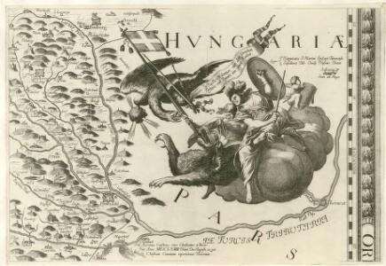
Bataille de St. Gotthard
Nouvel atlas physique politique et historique de l'Empire ottoman et des états limitrophes en Europe, en Asie et en Afrique, en quarante feuilles Hellert, J.J. Bellizard, Dufour et Cie
C. Castriferrei
Ungarn Komitat Vas
Comitat Eisenburg
1 : 290000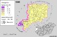
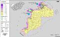
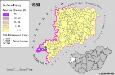
A szlovének arány és száma Vas megyében 1941-ben
Komitat Vas Slowenen, Siedlung Bottlik, Zsolt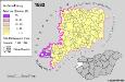
Slowenen im Komitat Vas 1880
Komitat Vas Slowenen, Siedlung Bottlik, Zsolt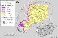
Slowenen im Komitat Vas 1941
Komitat Vas Slowenen, Siedlung Bottlik, Zsolt
Slowenen im Komitat Vas 1980
Komitat Vas Slowenen, Siedlung Bottlik, Zsolt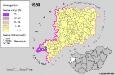
A szlovének arány és száma Vas megyében 1980-ban
Komitat Vas Slowenen, Siedlung Bottlik, Zsolt
Štajnamanger
1 : 200000 Szombathely (Maďarsko) Kartografska radionica
Hartberg und Pinkafeld (Ankafo).
from Spezialkarte der osterreichisch-ungarischen Monarchie.
[Steinamanger und Umgebung]
1 : 144000 K. u. k. Militärgeographisches Institut
Gleichenberg.
from Spezialkarte der osterreichisch-ungarischen Monarchie.
Guns.
from Spezialkarte der osterreichisch-ungarischen Monarchie.
Gleichenberg
1 : 75000 Bad Gleichenberg
Eisemburger Com. Tab. II
Ungarn Komitat Vas
Yugoslavia 1:100,000, Murska Sobota
Yugoslavia 1:100,000 , Series GSGS 4396. Great Britain. War Office. [London] : War Office
Nagycsákány
1 : 75000 Komitat Komárom-Esztergom
Czakany und Zala-Lovo (Ungarn).; Spezialkarte der osterreichisch-ungarischen Monarchie.
from Spezialkarte der osterreichisch-ungarischen Monarchie. Austro-Hungarian Monarchy. Militärgeographisches Institut.,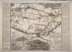
Situations Plan Der Gegend um Steinamanger, wo das adelich Hugarische Insurgenten Corps unter Comando Seiner Königlichen Hoheit des Erzherrzogs Joseph Palatinus vom 6ten Augusti bis 13ten September 1797 im Lager gestanden und im Manoeuvriren geübet worden
Ponheimer, Kilian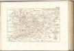

Der Noerdliche Theil von Untersteyermark oder der Graetzer Kreis
1 : 260000 Rakousko Kindermann, Joseph Karl Junker, Christoph bey Franz Xaver Miller
Generalkarte vom Burgenland
1 : 200000 Burgenland (Rakousko) R. Lechner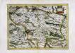
Stiria
1 Karte : Kupferdruck ; 29 x 40 cm Mercator; Hondius Henricus Hondius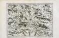
Stiria
1 Karte : Kupferdruck ; 29 x 40 cm Mercator s.n.