Maps of Primorje-Gorski Kotar County
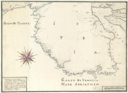
Vorstellung Deren von Triest umb das gantze Istrien Ligenden Merrhäfen oder gelegsamen örther denen nacher Triest und Fiume fährenden Schiffen infähl der Nots zu Sicherer einanckerung dienlichen büessen. Pickes Zeichen: bedeütet aller orthen den Port die difern aber das Wasser in Clafftern in die Tieffen
Mollova mapová sbírka Seiller, Johann Georg
Slavonien. Comitat Pozsega. Croatien: Comitate: Kövös, Varásd, Zágráb. Militär-Gränze. Regimenter: Likaner, Ottocháner, Oguliner, Szluiner, Köröser, Szent Györger und 2tes Báner und Gradiskaner Regiment
Ungarn Verkehrsweg
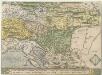
Sclauonia oder Windisch Marck, Bossen, Crabaten, ec
1 : 1200000 1 Karte : Holzschnitt ; 29 x 34 cm Münster, Sebastian [Sebastian Henricpetri]
Strassen- und Eisenbahnkarte des oesterreichischen Kaiserthumes
1 : 864000 Blatt 10 Schaller, G. K.K. Militärisch-Geografisches Institut, Karten-Evidenthaltungs-Abteilung
Illyricvm
1 : 1200000 Mollova mapová sbírka Sambucus, Joannes
Strassen und Eisenbahnkarte des oesterreichischen Kaiserthumes

Letecká mapa Evropy

Strassen Karte der croatischen Militair Grenze
1 : 440000 Bosna a Hercegovina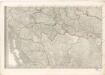
Mappa generalis regni Hungariae partiumque adnexarum Croatiae, Slavoniae...
Schlavoniae, Croatiae, Carniae, Istriae, Bosniae, Finitimarvmqve Regionvm Nova descriptio
1 : 520000 Mollova mapová sbírka Hirschvogel, Augustin Plantin, Christoph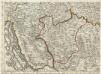
Augustissimo Romanor. Imperatori Iosepho I. Hungaria Regi Invictissimo Mappam Hanc Regni Hungariae
1 : 540000 Mollova mapová sbírka Müller, Johann Christoph
Croatia
Mollova mapová sbírka Hoffmann, Johannes Hoffmann, Johann
Königreich Kroatien nach der neuesten Begrenzung, und den vorzüglisten Hülfsmitteln bearbeitet
1 : 930000 Chorvatsko Tranquillo Mollo
Carte de la Croatie
Chorvatsko Kipferling, Karl Joseph Müller, Franz im Verlage des Kunst und Industrie Comptoirs
Strassen-Karte der Croatischen Militair-Grenze
1 : 430000 Chorvatsko K. k. Generalquartiermeisterstab
Vermehrte und Verbesserte Landkarten des Königreichs Ungarn :
1 : 500000 Mollova mapová sbírka Stier, Martin Böner, Johann-Alexander Endter, Martin
Strassen Karte der croatischen Militair Grenze
1 : 432000 Chorvatsko
Tabula Ducatus Carnioliae Vindorum Marchiae et Histriae ex mente Illustr.mi quondam L. B. Valvasorii concinnata et exhibita â Io. Bapt. Homanno S. C. M. Geogr.
Krain, Istrien Valvasor, Johann Weikhard <
Bez titulu: Istrie a Dalmatské pobřeží

Exactissima Ducatus Carniolae Vinidorum Marchiä et Histriae
1 : 500000 Mollova mapová sbírka Seutter, Matthäus
Königreich Dalmatien
1 : 1000000 Dalmácie (Chorvatsko)
Descriptio Totius Lyridis XVI. No. Tab. [Karte], in: Claud. Ptolemaeus. Geographia lat. cum mappis [...], S. 404.
1 Karte aus Atlas Münster, Sebastian [und Ptolemaeus, Claudius]
Karstia, Carniola, Histria et Windorvm Marchia
1 : 620000 Mollova mapová sbírka Mercator, Gerhard Schenk, Pieter Schenk, Peter I
Carniola Karstia Histria et Windorvm Marchia
1 : 660000 Mollova mapová sbírka Valvasor, Janez Vajkard Trost, Andreas Endter, Wolfgang Moritz
Ducatus Carnioliae Tabula
1 : 725000 Mollova mapová sbírka Pfeffel, Johann Andreas
Ducatus Carnioliae Tabula
1 : 725000 Mollova mapová sbírka Reiffenstuel, R.
Karstia, Carniola, Histria et Windorvm Marchia
1 : 620000 Mollova mapová sbírka Mercator, Gerhard Janssonius, Johannes Janssonius, Johannes I
Exactissima Ducatus Carniolae vinidorum Marchiä et Histriae delineatio
1 : 500000 Chorvatsko Lotter, Tobias Conrad T. C. Lotter
Exactissima ducatus Carniolae Vinidorum Marchiä et Histriae delineatio
1 : 500000 Cirknické jezero (Slovinsko) Lotter, Tobias Conrad Tob. Conr. Lotter
Exactissima ducatus Carniolae Vinidorum Marchiä et Histriae delineatio
1 : 500000 Cirknické jezero (Slovinsko) Lotter, Tobias Conrad Tob. Conr. Lotter