Maps of Gmunden

Austriae Archiducatus Superioris in suas Quadrantes Ditiones exacte divisi accuratissima Tabula
1 : 330000 Mollova mapová sbírka Vischer, Georg Matthaeus Homann, Johann Baptista
Austriae Archiducatus Superioris in suas Quadrantes Ditiones exacte divisi accuratißima Tabula
1 : 330000 Mollova mapová sbírka Vischer, Georg Matthaeus Homann, Johann Baptista
Nova Mappa Archiducatus Austriae Superioris Ditiones in suas Quadrantes divisas conspectui listens iuxta recentissimas observation adornata
1 : 330000 Mollova mapová sbírka Seutter, Matthäus Seutter, Matthäus
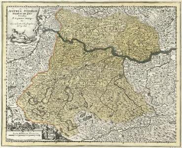
Avstria Svperior secundum IIII. Quadrantes & regiones contiguas
1 : 330000 Mollova mapová sbírka Weigel, Christoph Seutter, Matthäus
Austriae Archiducatus Pars Superior in omnes ejusdem Quadrantes Ditiones accuratissime ét distincté delineata
1 : 330000 Mollova mapová sbírka Vischer, Georg Matthaeus Vischer, Peter
Primus Quadrans Das Hausruck-Viertl
1 : 930000 Mollova mapová sbírka Fuhrmann, Mathias Märtin, Johann Heinrich Heyinger, Johann Ignaz
Primus Quadrans Das Hausruck-Viertl
1 : 930000 Mollova mapová sbírka Insprugger, Sebastianus Märtin, Johann Heinrich Schwendimann, Wolfgang
Mappa Electoratus et Ducatus Bavariae Superioris et Inferioris, Ducatus Neoburgesis cum Episcopatibus Frisingensi Ratisbonensi Passaviensi et Praepositura Bergtolsgadensi].
1 : 260000 Mollova mapová sbírka Apian, Philipp
Charte der Inn und Hausruck Viertel in dem Erzherzogthume Niederöstreich uiber der Enns
1 : 440000 Dolní Rakousko (Rakousko) Liechtenstern, Joseph Marx von Bendovsky, Thomas bey Joh. Schönberg
Umgebungen von Joschl und Salzburg
Bad Ischl (Rakousko) K. k. Österreichische Staatsbahnen
Charte des Traun Viertels in dem Erzherzogthume Niederöstreich uiber der Enns
1 : 440000 Dolní Rakousko (Rakousko) Liechtenstern, Joseph Marx von Bendovsky, Thomas bey Joh. Schönberg
Linz 145, uit: Special-Karte von Mittel-Europa / nach amtlichen Quellen bearbeitet von W. Liebenow
1 : 300000 titelvariant: W. Liebenow's Mittel-Europa; Annotatie: Titel boven de bladen: W. Liebenow's Mittel-Europa Johannes Wilhelm Liebenow 1822-1897 Frankfurt a. M. : Ludwig Ravenstein
183. Neuhaus (a. Inn.), uit: Topographische Uebersichtskarte des Deutschen Reiches / herausgegeben v. d. Kartogr. Abt. d. Königl. Preuß. Landesaufnahme
1 : 200000 titelvariant: Topogr. Übersichtskarte des Deutschen Reiches; Annotatie: Titel boven bladen ook: Topogr. Übersichtskarte des Deutschen Reiches; Annotatie geografische gegevens: Op elk blad twee maatstokken: 10 Kilometer = 5,5 cm; 1 geogr. Meile = 3,6 cm; Legenda onder op elk blad Königlich Preußische Landesaufnahme. Kartographische Abtheilung [S.l : Königlich Preußische Landesaufnahme, Kartographische Abtheilung]
Umgebung von Gmunden, Ischl, Hallstadt, Aussee
1 : 129600 Ausseerland (Rakousko) Maschek, Rudolf Artaria
Salzburg
1 : 200000 Herder, Benjamin
Übersichts-Karte vom Salzkammergute
1 : 143000 Solná komora (Rakousko) K. k. Finanz Ministerium
Archiducatus Austriae Superioris Geographica Descriptio. facta Anno 1667
1 : 150000 Mollova mapová sbírka Vischer, Georg Matthaeus Küssel, Melchior
Geographische Karte des ob der ennsischen Salzkammersguts
1 : 230000 Salcburk-oblast (Rakousko) Greiner, Johann Baptist Steiner, Johann Bapt.
Archiducatus Austriae Superioris Geographica Descriptio. facta Anno 1667
1 : 150000 Mollova mapová sbírka Vischer, Georg Matthaeus Küssel, Melchior
Pars IX. prodit partem Bavariæ sup: versus orientem et meridiem sitam ad Salam, Saltzam et Riv: Mattich, archiep: Salisburg. cum oris archiducat Austriæ super
1 Karte : 54 x 52 cm Heinrich Ludwig Broenner
[Umgebungen von Ried]
David, J.
Archiducatus Austriae Superioris Geographica Descriptio. facta Anno 1667
1 : 150000 Mollova mapová sbírka Vischer, Georg Matthaeus Küssel, Melchior
Reisekarte des Salzkammergutes und der angrenzenden Gebiete
1 : 100000 Solná komora (Rakousko) Mally, Em. Section Austria
Special-Karte für die Schluss-Manöver des 14. Corps 1890
1 : 75000 Horní Rakousko (Rakousko) K. u. k. militär-geographisches Institut
Karte des oesterrechisch kaiserlichen Salzkammergutes in Oberösterreich im Traunviertel
1 : 370000 Solná komora (Rakousko) Schultes Ausfeld, Johann Carl
Geographische Karte des Salzkammerguts
1 : 235000 Solná komora (Rakousko) Greiner, Johann Baptist Kaiser, Joseph Fr. Johann Bapt. Steiner
Carte topographique d'Allemagne contenant une partie de l'Autriche superieur [et] du duche de Stirie [et]c
1 Karte : Kupferdruck ; 45 x 63 cm Jaeger Jäger
Geographische Karte des ob der ennsischen Salzkammerguts
1 : 230000 Solná komora (Rakousko) Greiner, Johann Baptist Kaiser, Joseph Franz Johann Bap. Steiner
Geographische Karte des ob der ennsischen Salzkammerguts
1 : 230000 Solná komora (Rakousko) Greiner, Johann Baptist Kaiser, Joseph Franz Johann Bap. Steiner