Maps of Mayenne
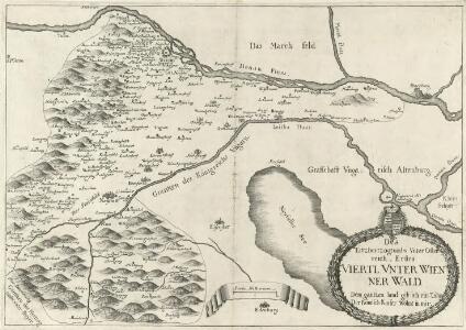
Des Erzherzogtumbs Vnter Osterreich, Erstes Viertl Vnter Wienner Wald. Dem gantzen land gib ich ein Zühr. Der Römisch Kaiser Wohnt in mir
Mollova mapová sbírka Vischer, Georg Matthaeus
Dept. De La Mayenne.
1 : 571000 Levasseur, Victor.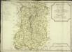
Direction des traittes de Laval ou se trouvent tous les bureaux, et les lieüx ou sont placez les brigades
1 Karte : Kupferdruck ; 46 x 66 cm Nolin; Jenvilliers chez l'auteur rue St. Jacques au dessus de la rue des Mathurins a lens.gne de la place des Victoires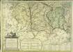
Partie inferieure occidentale de l'evesché du Mans
1 Blatt : Jaillot
Département de la Mayenne
1 Karte : Kupferdruck ; 48 x 48 cm Houdan; Dumez chez Dumez directeur de l'atlas national rue de la Harpe n.o 26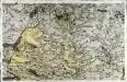
[Laval]
1 Blatt : 60 x 92 cm Chalmandrier s.n.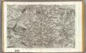
97 Laval.
1 : 86400 Cassini family; Cassini, Cesar-Francois, 1714-1784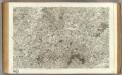
64 Le Mans.
1 : 86400 Cassini family; Cassini, Cesar-Francois, 1714-1784
A colored "plan de la ville de Rennes
A colored manuscript plan de la ville de Rennes, France, levé après l'incendie arrivé le 22e Decre. 1720; "drawn on a scale of 40 toises to an inch."
Le Maine [Karte], in: Gerardi Mercatoris et I. Hondii Newer Atlas, oder, Grosses Weltbuch, Bd. 2, S. 71.
1 Karte aus Atlas Mercator, Gerhard und Hondius, Jodocus Jansson, Jan
Cenomanorum Galliae regionis, typus. La Mans. [Karte], in: Theatrum orbis terrarum, S. 113.
1 Karte aus Atlas Ortelius, Abraham Vrients, Jan Baptista
Cenomanorum Galliae regionis, typus. La Mans. [Karte], in: Theatrum orbis terrarum, S. 66.
1 Karte aus Atlas Ortelius, Abraham
Ducatus Andegavensis [...] Aniou. [Karte], in: Novus Atlas, das ist, Weltbeschreibung, Bd. 2, S. 115.
1 Karte aus Atlas Blaeu, Joan Blaeu, Willem Janszoon
Cenomanorum Galliae regionis typus: Vulgo Le Mans. [Karte], in: Novus Atlas, das ist, Weltbeschreibung, Bd. 2, S. 118.
1 Karte aus Atlas Blaeu, Joan Blaeu, Willem Janszoon
Cenomanorum Galliae regionis typus: Vulgo Le Mans. [Karte], in: Theatrum orbis terrarum, sive, Atlas novus, Bd. 2, S. 79.
1 Karte aus Atlas Blaeu, Joan Blaeu, Willem Janszoon
Ducatus Andegavensis, [...] Aniou. [Karte], in: Le théâtre du monde, ou, Nouvel atlas contenant les chartes et descriptions de tous les païs de la terre, Bd. 2, S. 114.
1 Karte aus Atlas Blaeu, Willem Janszoon und Blaeu, Joan Blaeu, Willem Janszoon
Ducatus Andegavensis, [...] Aniou. [Karte], in: Theatrum orbis terrarum, sive, Atlas novus, Bd. 2, S. 87.
1 Karte aus Atlas Blaeu, Joan Blaeu, Willem Janszoon
Diocese Du Mans Vulgo Le Maine, ubi olim Cenomani. [Karte], in: Novus atlas absolutissimus, Bd. 4, S. 132.
1 Karte aus Atlas Janssonius Offizin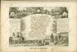

Diocese dv Mans vulgo le Maine
1 Karte : Kupferdruck ; 40 x 49 cm Sanson; Valck; Schenk apud G. Valk et P. Schenk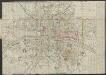
Aniou [Karte], in: Gerardi Mercatoris Atlas, sive, Cosmographicae meditationes de fabrica mundi et fabricati figura, S. 240.
1 Karte aus Atlas Mercator, Gerhard Montanus, Petrus
Anjou. Andegavensium Ditionis Vera Et Integra Descriptio. [Karte], in: Theatrum orbis terrarum, S. 123.
1 Karte aus Atlas Ortelius, Abraham Vrients, Jan Baptista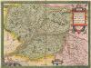
Anjou. Andegavensium Ditionis Vera Et Integra Descriptio. [Karte], in: Theatrum orbis terrarum, S. 76.
1 Karte aus Atlas Ortelius, Abraham

Le Maine
1 Karte : Kupferdruck ; 36 x 48 cm Mercator; Hondius Henricus Hondius
Cenomanorum galliae regionis typus : vulgo Le Mans
1 : 88000
DVCATVS | ANDEGAVENSIS, = ANIOV
Auctore Licimo Guÿeto Andegavense Amsterdami Apud Guiljelmum Blaeuw