Maps of powiat sulęciński

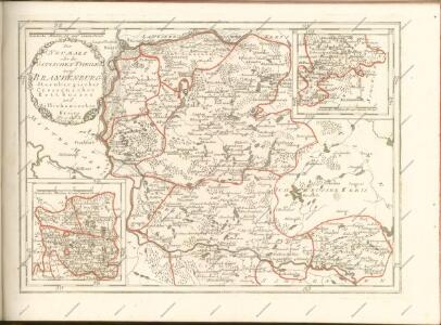
Der Sternbergsche Creis
1 : 292000 Sotzmann, Daniel Friedrich
91. Frankfurt a/O., uit: Topographische Uebersichtskarte des Deutschen Reiches / herausgegeben v. d. Kartogr. Abt. d. Königl. Preuß. Landesaufnahme
1 : 200000 titelvariant: Topogr. Übersichtskarte des Deutschen Reiches; Annotatie: Titel boven bladen ook: Topogr. Übersichtskarte des Deutschen Reiches; Annotatie geografische gegevens: Op elk blad twee maatstokken: 10 Kilometer = 5,5 cm; 1 geogr. Meile = 3,6 cm; Legenda onder op elk blad Königlich Preußische Landesaufnahme. Kartographische Abtheilung [S.l : Königlich Preußische Landesaufnahme, Kartographische Abtheilung]
297.1 Zielenzig.
1 : 100000 Reichsamt fur Landesaufnahme
Composite: 320. Furstenberg.
1 : 100000 Reichsamt fur Landesaufnahme
Composite: 297 Zielenzig.
1 : 100000 Reichsamt fur Landesaufnahme
Composite: 321. Krossen a. d. Oder.
1 : 100000 Reichsamt fur Landesaufnahme
297. Zielenzig.
1 : 100000 Reichsamt fur Landesaufnahme
Plan von der Battaille bey Cunersdorf am 12ten August 1759

Composite: 322. Zullichau.
1 : 100000 Reichsamt fur Landesaufnahme
Okrestnosti Kunnersdorfa
Polen Kunersdorf Siebenjähriger Krieg
322.1. Zullichau.
1 : 100000 Reichsamt fur Landesaufnahme
322. Zullichau.
1 : 100000 Reichsamt fur Landesaufnahme
298.1. Meseritz.
1 : 100000 Reichsamt fur Landesaufnahme
Composite: 298.1. Meseritz.
1 : 100000 Reichsamt fur Landesaufnahme
298. Meseritz.
1 : 100000 Reichsamt fur Landesaufnahme
Bataille de Cunersdorf

Sraženīe pri Kunnersdorfě 1 avgusta 1759 g.
Polen Kunersdorf Siebenjähriger Krieg Schlacht bei Kunersdorf
Plan der Bataille welche zwischen der Kaysl. Russischen u. König. Preuss. Armeen den 25. Aug. 1758 bey Zorndorf in der neuen Markt Brandenburg vorgefallen
Mollova mapová sbírka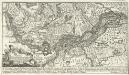
Plan der Bataille qui s'est donnée le 25. d'Août 1758 entre l'Armée Impar de Russie et celle du R. de Rrussepräs de Zorndorf dans la Nor. Machr. Brandenb.
Mollova mapová sbírka
Meßtischblatt 3959 : Züllichau, 1944
1 : 250000 Züllichau. - Aufn. 1894, hrsg. 1896, bericht. 1944. - 1:25000. - [Berlin]: Reichsamt für Landesaufnahme, 1944. - 1 Kt.
Meßtischblatt 3958 : Rothenburg (Oder), 1938
1 : 250000 Rothenburg (Oder). - Hrsg. 1896, bericht. 1933, redakt. Änd. 1938. - 1:25000. - [Berlin]: Reichsamt für Landesaufnahme, 1938. - 1 Kt.
Meßtischblatt 2189 : Rädnitz, 1909
1 : 250000 Rädnitz. - Aufn. 1894, hrsg. 1896, einzelne Nachtr. 1909. - 1:25000. - [Berlin]: Reichsamt für Landesaufnahme, 1909. - 1 Kt.
Meßtischblatt 2188 : Crossen a. d. Oder, 1933
1 : 250000 Crossen a. d. Oder. - Aufn. 1894. - 1:25000. - [Berlin]: Reichsamt für Landesaufnahme, 1933. - 1 Kt.
Meßtischblatt 2188 : Krossen a. d. Oder, 1896
1 : 250000 Krossen a. d. Oder. - Aufn. 1894. - 1:25000. - [Berlin]: Reichsamt für Landesaufnahme, 1896. - 1 Kt.
Meßtischblatt 2187 : Merzwiese, 1923
1 : 250000 Merzwiese. - Aufn. 1894, Nachtr. 1923. - 1:25000. - [Berlin]: Reichsamt für Landesaufnahme, 1923. - 1 Kt.
Meßtischblatt 3954 : Wellmitz, 1938
1 : 250000 Wellmitz. - Hrsg. 1896, bericht. 1934, redakt. Änd. 1938. - 1:25000. - [Berlin]: Reichsamt für Landesaufnahme, 1938. - 1 Kt.
Meßtischblatt 2185 : Neuzelle, 1925
1 : 250000 Neuzelle. - Aufn. 1894, bericht. 1925. - 1:25000. - [Berlin]: Reichsamt für Landesaufnahme, 1925. - 1 Kt.
Meßtischblatt 2185 : Neuzelle, 1896
1 : 250000 Neuzelle. - Aufn. 1894. - 1:25000. - [Berlin]: Reichsamt für Landesaufnahme, 1896. - 1 Kt.