Maps of powiat koszaliński

46. Labes, uit: Topographische Uebersichtskarte des Deutschen Reiches / herausgegeben v. d. Kartogr. Abt. d. Königl. Preuß. Landesaufnahme
1 : 200000 titelvariant: Topogr. Übersichtskarte des Deutschen Reiches; Annotatie: Titel boven bladen ook: Topogr. Übersichtskarte des Deutschen Reiches; Annotatie geografische gegevens: Op elk blad twee maatstokken: 10 Kilometer = 5,5 cm; 1 geogr. Meile = 3,6 cm; Legenda onder op elk blad Königlich Preußische Landesaufnahme. Kartographische Abtheilung [S.l : Königlich Preußische Landesaufnahme, Kartographische Abtheilung]
29. Kolberg, uit: Topographische Uebersichtskarte des Deutschen Reiches / herausgegeben v. d. Kartogr. Abt. d. Königl. Preuß. Landesaufnahme
1 : 200000 titelvariant: Topogr. Übersichtskarte des Deutschen Reiches; Annotatie: Titel boven bladen ook: Topogr. Übersichtskarte des Deutschen Reiches; Annotatie geografische gegevens: Op elk blad twee maatstokken: 10 Kilometer = 5,5 cm; 1 geogr. Meile = 3,6 cm; Legenda onder op elk blad Königlich Preußische Landesaufnahme. Kartographische Abtheilung [S.l : Königlich Preußische Landesaufnahme, Kartographische Abtheilung]
126. Bublitz. (Germany)
1 : 100000 Reichsamt fur Landesaufnahme
Composite: 126. Bublitz. (Germany)
1 : 100000 Reichsamt fur Landesaufnahme
Composite: 94.1. Koslin. (Germany)
1 : 100000 Reichsamt fur Landesaufnahme
Composite: 93. Kolberg. (Germany)
1 : 100000 Reichsamt fur Landesaufnahme
94. Coslin. (Germany)
1 : 100000 Reichsamt fur Landesaufnahme
94.1. Koslin. (Germany)
1 : 100000 Reichsamt fur Landesaufnahme
Composite: 124. Schivelbein. (Germany)
1 : 100000 Reichsamt fur Landesaufnahme
124. Schivelbein. (Germany)
1 : 100000 Reichsamt fur Landesaufnahme
93. Kolberg. (Germany)
1 : 100000 Reichsamt fur Landesaufnahme
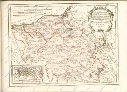
Der Schiefelbeinsche Creis
1 : 296000 Sotzmann, Daniel Friedrich
Plan der Belagerung von Colberg vom 3. Oct. bis 1. Nov. 1758
Mollova mapová sbírka
Meßtischblatt 876, neue Nr. 2265 : Persanzig, 1937
1 : 250000 Persanzig. - Aufn. 1933/34. - 1:25000. - [Berlin]: Reichsamt für Landesaufnahme, 1937. - 1 Kt.
Meßtischblatt 2264 : Bärwalde, 1940
1 : 250000 Bärwalde. - Aufn. 1934, redakt. Änd. 1938. - 1:25000. - [Berlin]: Reichsamt für Landesaufnahme, 1940. - 1 Kt.
Meßtischblatt 873 : Bad Polzin, 1936
1 : 250000 Bad Polzin. - Aufn. 1889, bericht. 1936. - 1:25000. - [Berlin]: Reichsamt für Landesaufnahme, 1936. - 1 Kt.
Meßtischblatt 872 : Reinfeld, 1936
1 : 250000 Reinfeld. - Aufn. 1889, bericht. 1936. - 1:25000. - [Berlin]: Reichsamt für Landesaufnahme, 1936. - 1 Kt.
Meßtischblatt 877, neue Nr. 2266 : Neustettin, 1936
1 : 250000 Neustettin. - Neuaufn. 1935, mehrfarb. Ausg. 1936. - 1:25000. - [Berlin]: Reichsamt für Landesaufnahme, 1936. - 1 Kt.
Meßtischblatt 2263 : Kollatz, 1891
1 : 250000 Kollatz. - [Aufn. 1889]. - 1:25000. - [Berlin]: Reichsamt für Landesaufnahme, 1891. - 1 Kt.
Meßtischblatt 871 : Schivelbein, 1890
1 : 250000 Schivelbein. - Aufn. 1889. - 1:25000. - [Berlin]: Reichsamt für Landesaufnahme, 1890. - 1 Kt.
Meßtischblatt 870 : Rützenhagen, 1891
1 : 250000 Rützenhagen. - Aufn. 1889. - 1:25000. - [Berlin]: Reichsamt für Landesaufnahme, 1891. - 1 Kt.
Meßtischblatt 2165 : Wurchow, 1939
1 : 250000 Wurchow. - Aufn. 1934, hrsg. 1939. - 1:25000. - [Berlin]: Reichsamt für Landesaufnahme, 1939. - 1 Kt.
Meßtischblatt 2164 : Gramenz, 1942
1 : 250000 Gramenz. - Aufn. 1935, hrsg. 1942. - 1:25000. - [Berlin]: Reichsamt für Landesaufnahme, 1942. - 1 Kt.
Meßtischblatt 779 : Wusterbarth, 1936
1 : 250000 Wusterbarth. - Aufgen. 1889, hrsg. 1891, bericht. 1936. - 1:25000. - [Berlin]: Reichsamt für Landesaufnahme, 1936. - 1 Kt.
Meßtischblatt 2161 : Arnhausen, 1936
1 : 250000 Arnhausen. - Aufgen. 1889, hrsg. 1891, bericht. 1936. - 1:25000. - [Berlin]: Reichsamt für Landesaufnahme, 1936. - 1 Kt.
Meßtischblatt 783 : Kasimirshof, 1936
1 : 250000 Kasimirshof. - Aufgen. 1933. - 1:25000. - [Berlin]: Reichsamt für Landesaufnahme, 1936. - 1 Kt.
Meßtischblatt 2163 : Gr. Krössin, 1936
1 : 250000 Gr. Krössin. - Aufgen. 1889, hrsg. 1891, bericht. 1936. - 1:25000. - [Berlin]: Reichsamt für Landesaufnahme, 1936. - 1 Kt.
Meßtischblatt 2160 : Stolzenberg, 1941
1 : 250000 Stolzenberg. - Aufn. 1889, hrsg. 1891, bericht. 1938. - 1:25000. - [Berlin]: Reichsamt für Landesaufnahme, 1941. - 1 Kt.