Maps of powiat łobeski

45. Wollin, uit: Topographische Uebersichtskarte des Deutschen Reiches / herausgegeben v. d. Kartogr. Abt. d. Königl. Preuß. Landesaufnahme
1 : 200000 titelvariant: Topogr. Übersichtskarte des Deutschen Reiches; Annotatie: Titel boven bladen ook: Topogr. Übersichtskarte des Deutschen Reiches; Annotatie geografische gegevens: Op elk blad twee maatstokken: 10 Kilometer = 5,5 cm; 1 geogr. Meile = 3,6 cm; Legenda onder op elk blad Königlich Preußische Landesaufnahme. Kartographische Abtheilung [S.l : Königlich Preußische Landesaufnahme, Kartographische Abtheilung]
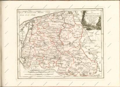
Der Schiefelbeinsche Creis
1 : 296000 Sotzmann, Daniel Friedrich
Composite: 156. Naugard. (Germany)
1 : 100000 Reichsamt fur Landesaufnahme
Composite: 124. Schivelbein. (Germany)
1 : 100000 Reichsamt fur Landesaufnahme
124. Schivelbein. (Germany)
1 : 100000 Reichsamt fur Landesaufnahme
157. Labes. (Germany)
1 : 100000 Reichsamt fur Landesaufnahme
Composite: 157. Labes. (Germany)
1 : 100000 Reichsamt fur Landesaufnahme
156. Naugard. (Germany)
1 : 100000 Reichsamt fur Landesaufnahme
92. Treptow a. d. Rega. (Germany)
1 : 100000 Reichsamt fur Landesaufnahme
122. Wollin. (Germany)
1 : 100000 Reichsamt fur Landesaufnahme
Plan der Belagerung von Colberg vom 3. Oct. bis 1. Nov. 1758
Mollova mapová sbírka
93. Kolberg. (Germany)
1 : 100000 Reichsamt fur Landesaufnahme
Composite: 155. Politz. (Germany)
1 : 100000 Reichsamt fur Landesaufnahme
Composite: 93. Kolberg. (Germany)
1 : 100000 Reichsamt fur Landesaufnahme
Composite: 92. Treptow a. d. Rega. (Germany)
1 : 100000 Reichsamt fur Landesaufnahme
Meßtischblatt 2460 : Dramburg, 1943
1 : 250000 Dramburg. - Aufn. 1890, hrsg. 1892, bericht. 1936. - 1:25000. - [Berlin]: Reichsamt für Landesaufnahme, 1943. - 1 Kt.
Meßtischblatt 1063 : Wangerin, 1938
1 : 250000 Wangerin. - Aufn. 1890, hrsg. 1892, bericht. 1936. - 1:25000. - [Berlin]: Reichsamt für Landesaufnahme, 1938. - 1 Kt.
Meßtischblatt 1062 : Silligsdorf, 1936
1 : 250000 Silligsdorf. - Hrsg. 1892, bericht. 1936. - 1:25000. - [Berlin]: Reichsamt für Landesaufnahme, 1936. - 1 Kt.
Meßtischblatt 2457 : Daber, 1929
1 : 250000 Daber. - Hrsg. 1892, einz. Nachtr. 1929. - 1:25000. - [Berlin]: Reichsamt für Landesaufnahme, 1929. - 1 Kt.
Meßtischblatt 2456 : Eichenwalde, 1929
1 : 250000 Eichenwalde. - Hrsg. 1892, einz. Nachtr. 1929. - 1:25000. - [Berlin]: Reichsamt für Landesaufnahme, 1929. - 1 Kt.
Meßtischblatt 2455 : Speck, 1929
1 : 250000 Speck. - Hrsg. 1892, einz. Nachtr. 1922, gedr. [19]29. - 1:25000. - [Berlin]: Reichsamt für Landesaufnahme, 1929. - 1 Kt.
Meßtischblatt 2454 : Gollnow, 1910
1 : 250000 Gollnow. - Aufn. 1886, hrsg. 1888, einz. Nachtr. 1898, gedr. [19]10. - 1:25000. - [Berlin]: Reichsamt für Landesaufnahme, 1910. - 1 Kt.
Meßtischblatt 2360 : Labenz, 1936
1 : 250000 Labenz. - Hrsg. 1892, bericht. 1936. - 1:25000. - [Berlin]: Reichsamt für Landesaufnahme, 1936. - 1 Kt.
Meßtischblatt 967 : Labes, 1892
1 : 250000 Labes. - Aufn. 1890. - 1:25000. - [Berlin]: Reichsamt für Landesaufnahme, 1892. - 1 Kt.
Meßtischblatt 966 : Gr. Borckenhagen, 1892
1 : 250000 Gr. Borckenhagen. - Aufn. 1890. - 1:25000. - [Berlin]: Reichsamt für Landesaufnahme, 1892. - 1 Kt.
Meßtischblatt 2357 : Farbezin, 1936
1 : 250000 Farbezin. - Hrsg. 1891, einz. Nachtr. 1929. - 1:25000. - [Berlin]: Reichsamt für Landesaufnahme, 1936. - 1 Kt.
Meßtischblatt 964 : Naugard, 1891
1 : 250000 Naugard. - Aufn. 1889. - 1:25000. - [Berlin]: Reichsamt für Landesaufnahme, 1891. - 1 Kt.
Meßtischblatt 2355 : Basenthin, 1929
1 : 250000 Basenthin. - Hrsg. 1891, einz. Nachtr. 1929. - 1:25000. - [Berlin]: Reichsamt für Landesaufnahme, 1929. - 1 Kt.