Maps of Landkreis Harz

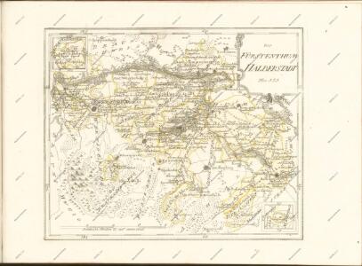
Principatus Halberstadiensis, abbat. Quedlinburgens cum comitatu Wernigerodano, ad hodiernum verum statum ex acta prodiit
1 : 135000 Halberstadt (Německo) Seutter, Matthäus Lotter, Tobias Conrad M. Seutter
Principatus Halberstadiensis, abbat. Quedlinburgens cum comitatu Wernigerodano, ad hodiernum verum statum ex acta prodiit
1 : 135000 Halberstadt (Německo) Seutter, Matthäus Lotter, Tobias Conrad ex officina Matthaei Seutteri
100. Halberstadt, uit: Topographische Uebersichtskarte des Deutschen Reiches / herausgegeben v. d. Kartogr. Abt. d. Königl. Preuß. Landesaufnahme
1 : 200000 titelvariant: Topogr. Übersichtskarte des Deutschen Reiches; Annotatie: Titel boven bladen ook: Topogr. Übersichtskarte des Deutschen Reiches; Annotatie geografische gegevens: Op elk blad twee maatstokken: 10 Kilometer = 5,5 cm; 1 geogr. Meile = 3,6 cm; Legenda onder op elk blad Königlich Preußische Landesaufnahme. Kartographische Abtheilung [S.l : Königlich Preußische Landesaufnahme, Kartographische Abtheilung]
Principatus Halberstadiensis Abbat: Quedlinburgens cum Comitatu Wernigerodano
1 : 180000 Mollova mapová sbírka Seutter, Matthäus Lotter, Tobias Conrad Seutter, Matthäus

Berge des Harzes
Geologischer Atlas zur Naturgeschichte der Erde Leonhard, Carl Cäsar von E. Schweizerbart'sche Verlagsbuchhandlung
Composite: 337. Halberstadt.
1 : 100000 Reichsamt fur Landesaufnahme
337. Halberstadt.
1 : 100000 Reichsamt fur Landesaufnahme
Abbildung des Brocken-Gebürges eines Theils des Harzes und Vorharzes
1 : 79000 Harz (Německo) Schroeder, C. F. Rückling
Composite: 336. Goslar.
1 : 100000 Reichsamt fur Landesaufnahme
336. Goslar.
1 : 100000 Reichsamt fur Landesaufnahme
313. Oschersleben.
1 : 100000 Reichsamt fur Landesaufnahme
Meßtischblatt 2383 : Aschersleben, 1934
1 : 250000 Aschersleben. - Hrsg. 1904, bericht. 1926, einz. Nachtr. 1934. - 1:25000. - [Berlin]: Reichsamt für Landesaufnahme, 1934. - 1 Kt.
Meßtischblatt 2382 : Ballenstedt, 1934
1 : 250000 Ballenstedt. - Hrsg. 1904, einz. Nachtr. 1934. - 1:25000. - [Berlin]: Reichsamt für Landesaufnahme, 1934. - 1 Kt.
Meßtischblatt 2382 : Ballenstedt, 1904
1 : 250000 Ballenstedt. - Aufn. 1903. - 1:25000. - [Berlin]: Reichsamt für Landesaufnahme, 1904. - 1 Kt.
Meßtischblatt 4232 : Quedlinburg, 1936
1 : 250000 Quedlinburg. - Hrsg. 1905, einz. Nachtr. 1934. - 1:25000. - [Berlin]: Reichsamt für Landesaufnahme, 1936. - 1 Kt.
Meßtischblatt 2381 : Quedlinburg, 1919
1 : 250000 Quedlinburg. - Aufn. 1903, hrsg. 1905. - 1:25000. - [Berlin]: Reichsamt für Landesaufnahme, 1919. - 1 Kt.
Meßtischblatt 2381 : Quedlinburg, 1911
1 : 250000 Quedlinburg. - Aufn. 1903, hrsg. 1905, einzelne Nachtr. 1909, gedr. [19]11. - 1:25000. - [Berlin]: Reichsamt für Landesaufnahme, 1911. - 1 Kt.
Meßtischblatt 4232 : Quedlinburg, 1898?
1 : 250000 Quedlinburg. - 1:25000. - [Berlin]: Reichsamt für Landesaufnahme, [1898?]. - 1 Kt.
Meßtischblatt 2381 : Quedlinburg, 1876
1 : 250000 Quedlinburg. - Aufn. 1852, hrsg. 1870, bericht. 1876. - 1:25000. - [Berlin]: Reichsamt für Landesaufnahme, 1876. - 1 Kt.
Meßtischblatt 2380 : Blankenburg am Harz, 1934
1 : 250000 Blankenburg am Harz. - Hrsg. 1905, bericht. 1913, einz. Nachtr. 1934. - 1:25000. - [Berlin]: Reichsamt für Landesaufnahme, 1934. - 1 Kt.
Meßtischblatt 2380 : Blankenburg, 1905
1 : 250000 Blankenburg. - Aufn. 1903. - 1:25000. - [Berlin]: Reichsamt für Landesaufnahme, 1905. - 1 Kt.
Meßtischblatt 2380 : Blankenburg, 1888
1 : 250000 Blankenburg. - Aufn. 1857, hrsg. 1870, bericht. 1888. - 1:25000. - [Berlin]: Reichsamt für Landesaufnahme, 1888. - 1 Kt.
Meßtischblatt 2379 : Elbingerode, 1937
1 : 250000 Elbingerode. - Hrsg. 1909, einz. Nachtr. 1937. - 1:25000. - [Berlin]: Reichsamt für Landesaufnahme, 1937. - 1 Kt.
Meßtischblatt 2379 : Elbingerode, 1918
1 : 250000 Elbingerode. - Aufn. 1907, hrsg. 1909, Aufldr. 1918. - 1:25000. - [Berlin]: Reichsamt für Landesaufnahme, 1918. - 1 Kt.
Meßtischblatt 2379 : Elbingerode, 1877
1 : 250000 Elbingerode. - Aufn. 1857, hrsg. 1870, bericht. 1877. - 1:25000. - [Berlin]: Reichsamt für Landesaufnahme, 1877. - 1 Kt.
Meßtischblatt 2378 : St. Andreasberg, 1937
1 : 250000 St. Andreasberg. - Hrsg. 1909, einz. Nachtr. 1934, gedr. [19]37. - 1:25000. - [Berlin]: Reichsamt für Landesaufnahme, 1937. - 1 Kt.
Meßtischblatt 2378 : St. Andreasberg, 1909
1 : 250000 St. Andreasberg. - Aufn. 1907. - 1:25000. - [Berlin]: Reichsamt für Landesaufnahme, 1909. - 1 Kt.
Meßtischblatt 4134 : Cochstedt, 1934
1 : 250000 Cochstedt. - Aufn. 1902, hrsg. 1904. - 1:25000. - [Berlin]: Reichsamt für Landesaufnahme, 1934. - 1 Kt.