Maps of Region Hannover

73. Celle, uit: Topographische Uebersichtskarte des Deutschen Reiches / herausgegeben v. d. Kartogr. Abt. d. Königl. Preuß. Landesaufnahme
1 : 200000 titelvariant: Topogr. Übersichtskarte des Deutschen Reiches; Annotatie: Titel boven bladen ook: Topogr. Übersichtskarte des Deutschen Reiches; Annotatie geografische gegevens: Op elk blad twee maatstokken: 10 Kilometer = 5,5 cm; 1 geogr. Meile = 3,6 cm; Legenda onder op elk blad Königlich Preußische Landesaufnahme. Kartographische Abtheilung [S.l : Königlich Preußische Landesaufnahme, Kartographische Abtheilung]
Composite: 262. Celle.
1 : 100000 Reichsamt fur Landesaufnahme
236. Walsrode.
1 : 100000 Reichsamt fur Landesaufnahme
Composite: 236. Walsrode.
1 : 100000 Reichsamt fur Landesaufnahme
Composite: 237. Soltau.
1 : 100000 Reichsamt fur Landesaufnahme
237. Soltau.
1 : 100000 Reichsamt fur Landesaufnahme
262. Celle.
1 : 100000 Reichsamt fur Landesaufnahme
Composite: 286. Hannover.
1 : 100000 Reichsamt fur Landesaufnahme
286. Hannover.
1 : 100000 Reichsamt fur Landesaufnahme
287. Lehrte.
1 : 100000 Reichsamt fur Landesaufnahme
Composite: 287. Lehrte.
1 : 100000 Reichsamt fur Landesaufnahme
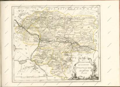
Geognostische Karte der Umgegend von Hannover
1 : 100000 Credner, Heinrich Hahn'sche Hofbuchhandlung
261. Neustadt a. Rubenberge.
1 : 100000 Reichsamt fur Landesaufnahme
Composite: 261. Neustadt a. Rubenberge.
1 : 100000 Reichsamt fur Landesaufnahme
Meßtischblatt 1958 : Wendeburg, 1937
1 : 250000 Wendeburg. - [Aufn. 1896], hrsg. 1901, bericht. 1934, einzelne Nachtr. 1936, mehrfarb. Ausg. 1937. - 1:25000. - [Berlin]: Reichsamt für Landesaufnahme, 1937. - 1 Kt.
Meßtischblatt 1958 : Wendeburg, 1924
1 : 250000 Wendeburg. - Aufn. 1899, bericht. 1924. - 1:25000. - [Berlin]: Reichsamt für Landesaufnahme, 1924. - 1 Kt.
Meßtischblatt 3628 : Erstein, 1884
1 : 250000 Erstein. - Aufn. 1883. - 1:25000. - [Berlin]: Reichsamt für Landesaufnahme, 1884. - 1 Kt.
Meßtischblatt 1957 : Peine, 1897
1 : 250000 Peine. - Aufn. 1896, hrsg. 1897. - 1:25000. - [Berlin]: Reichsamt für Landesaufnahme, 1897. - 1 Kt.
Meßtischblatt 1956 : Haimar, 1924
1 : 250000 Haimar. - Aufn. 1896, bericht. 1924. - 1:25000. - [Berlin]: Reichsamt für Landesaufnahme, 1924. - 1 Kt.
Meßtischblatt 1955 : Lehrte, 1898
1 : 250000 Lehrte. - Aufn. 1896, hrsg. 1898. - 1:25000. - [Berlin]: Reichsamt für Landesaufnahme, 1898. - 1 Kt.
Meßtischblatt 3624 : Hannover, 1940
1 : 250000 Hannover. - Aufn. 1896 u. 1929/35, hrsg. 1898, bericht. 1936. - 1:25000. - [Berlin]: Reichsamt für Landesaufnahme, 1940. - 1 Kt.
Meßtischblatt 1954 : Hannover, 1934
1 : 250000 Hannover. - Aufn. 1896, bericht. 1920, kl. Nachtr. 1924, gedr. [19]34. - 1:25000. - [Berlin]: Reichsamt für Landesaufnahme, 1934. - 1 Kt.
Meßtischblatt 1952 : Rodenberg, 1898
1 : 250000 Rodenberg. - Aufn. 1896. - 1:25000. - [Berlin]: Reichsamt für Landesaufnahme, 1898. - 1 Kt.
Meßtischblatt 1890 : Meinersen, 1901
1 : 250000 Meinersen. - Aufn. 1899. - 1:25000. - [Berlin]: Reichsamt für Landesaufnahme, 1901. - 1 Kt.
Meßtischblatt 1889 : Ütze, 1898
1 : 250000 Ütze. - Aufn. 1896, hrsg. 1898. - 1:25000. - [Berlin]: Reichsamt für Landesaufnahme, 1898. - 1 Kt.
Meßtischblatt 1888 : Burgdorf, 1898
1 : 250000 Burgdorf. - Aufn. 1896. - 1:25000. - [Berlin]: Reichsamt für Landesaufnahme, 1898. - 1 Kt.
Meßtischblatt 1887 : Gr. Burgwedel, 1898
1 : 250000 Gr. Burgwedel. - Aufn. 1896. - 1:25000. - [Berlin]: Reichsamt für Landesaufnahme, 1898. - 1 Kt.
Meßtischblatt 1886 : Isernhagen, 1937
1 : 250000 Isernhagen. - Hrsg. 1897, bericht. 1933, mehrfarb. Ausg. 1937. - 1:25000. - [Berlin]: Reichsamt für Landesaufnahme, 1937. - 1 Kt.