Maps of Lombardy


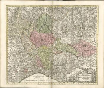
Ducatus Mediolanensis cum adjacentibus Principat. Et Dominiis


Le Duché de Milan dans toute son estendüe divisé en ses principales parties, avec les estats et frontieres qui l'environnent
1 : 520000 par Pierre Mortier A Amsterdam : chez P. Mortier
Le Duché de Milan dans toute son estendüe divisé en ses principales parties, avec les estats et frontieres qui l'environnent, où sont exactement marquée les route[s] des impériaux, &c
1 : 520000 par Pierre Mortier A Amsterdam : chez P. Mortier
Ducatus Mediolanensis Placentini et Parmensis nova tabula
1 Karte : Kupferdruck ; 32 x 38 cm Weigel; Kauffer Christoph Weigel
De Stoel des Oorlogs in Italien
1 : 750000 Mollova mapová sbírka Visscher, Nicolaes Anse, Luggert van Schenk, Peter II
Ducatus Mediolanensis cum adjacentibus principat. et dominiis accuratissime delineatus
1 : 536000 Itálie severní Seutter, Matthäus sumptibus Matthaei Seuteri
Status Mediolanensis nec non Ducatum Mantuae, Modenae, Parmae ut et Genuensis Reipublicae
1 : 720000 Mollova mapová sbírka Valk, Gerhard Overton, John
XI, uit: General-Karte des oesterreichischen Kaiserstaates mit einem grossen Theile der angrenzenden Länder / durch Josef Scheda ... bearb. und hrsg
1 : 576000 Annotatie geografische gegevens: Maatstokken: oesterreichische Meilen, geografische oder deutsche Meilen, preussische Meilen, türkische Berri, französische Lieues, russische Werste; Maatstok per blad: wiener Klafter, öster. Meilen; Blad XIX: statistische en taalkundige informatie; Blad XIX: legenda [Wien : K.K. Militärisch-Geografisches Institut]
Longobardia Divisa in status suos
1 : 900000 Mollova mapová sbírka Wolf, Jeremias Wolff, Jeremias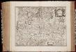
Stato di Milano
1 : 500000 Annotatie: Origineel is Blad 155 in atlas factice; Annotatie geografische gegevens: Schaalstok: Scala di miglia tredeci d'Italia [Amstelodami] : [apud Ioannem Ianssonium]
La Lombardie
1 : 730000 Mollova mapová sbírka Tralage, Jean-Nicolas de Nolin, Jean Baptiste
Longobardia divisa in status suos qui sunt
1 : 910000 Lombardie (Itálie) Cantelli, Giacomo apud Tobiam Conrad Lotter

DUCATUS MEDIOLANI
1 : 530000 Milán-oblast (Itálie) Homann, Johann Baptist per Ioh. Bapt. Hommanum
DUCATUS MEDIOLANI
1 : 530000 Milán-oblast (Itálie) Homann, Johann Baptist per Ioh. Bapt. Hommanum
Ducatus Mediolani
1 : 530000 Milán-oblast (Itálie) Homann, Johann Baptist per Ioh. Bapt. Hommanum
E.7. Mailand, uit: [Übersichtskarte von Europa 1:750.000]
1 : 750000 Wien : K.u.K. Militärgeographisches Institut
Stato Di Milano [Karte], in: Novus atlas absolutissimus, Bd. 5, S. 68.
1 Karte aus Atlas Janssonius Offizin
Mediolanum Ducatus. [Karte], in: Gerardi Mercatoris et I. Hondii Newer Atlas, oder, Grosses Weltbuch, Bd. 2, S. 264.
1 Karte aus Atlas Mercator, Gerhard und Hondius, Jodocus Jansson, Jan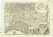
Statto di Milano e prouincie confinanti dalla parte orientale &
1 : 755000 Itálie severní Frattino, Giulio Carlo Surello, D.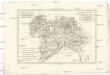
La Savoie, le Piémont, le Mont-Ferrat, et la république de Genes, avec les duchés de Milan et de Parme
1 : 1770000 Janov-oblast (Itálie) Bonne, Rigobert
Stato Di Milano [Karte], in: Le théâtre du monde, ou, Nouvel atlas contenant les chartes et descriptions de tous les païs de la terre, Bd. 3, S. 60.
1 Karte aus Atlas Blaeu, Willem Janszoon und Blaeu, Joan Blaeu, Willem Janszoon
Theater des Oorlogs in Lombardye
1 : 520000 Mollova mapová sbírka
Le Duché de Milan
1 : 520000 Mollova mapová sbírka Mortier, Cornelis Covens, Johannes I
Belli typvs in Itallia, victricis aquilae progreßus in statv Mediolanensi et dvcatv Mantvae demonstrants
1 : 530000 Itálie severní Homann, Johann Baptist Io. Bapt. Homannum