Maps of Rostock

43. Neubrandenburg, uit: Topographische Uebersichtskarte des Deutschen Reiches / herausgegeben v. d. Kartogr. Abt. d. Königl. Preuß. Landesaufnahme
1 : 200000 titelvariant: Topogr. Übersichtskarte des Deutschen Reiches; Annotatie: Titel boven bladen ook: Topogr. Übersichtskarte des Deutschen Reiches; Annotatie geografische gegevens: Op elk blad twee maatstokken: 10 Kilometer = 5,5 cm; 1 geogr. Meile = 3,6 cm; Legenda onder op elk blad Königlich Preußische Landesaufnahme. Kartographische Abtheilung [S.l : Königlich Preußische Landesaufnahme, Kartographische Abtheilung]
117. Gustrow. (Germany)
1 : 100000 Reichsamt fur Landesaufnahme
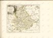
Composite: 86. Rostock. (Germany)
1 : 100000 Reichsamt fur Landesaufnahme
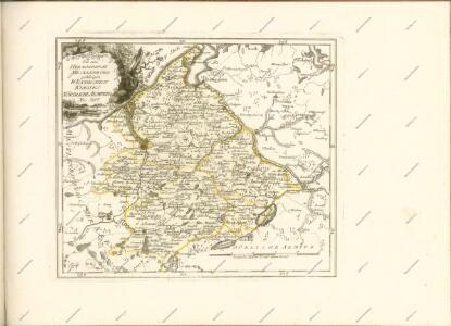
Wanderkarte Rostock und Umgebung

86. Rostock. (Germany)
1 : 100000 Reichsamt fur Landesaufnahme
118. Teterow. (Germany)
1 : 100000 Reichsamt fur Landesaufnahme
Composite: 118. Teterow. (Germany)
1 : 100000 Reichsamt fur Landesaufnahme
Composite: 117. Gustrow. (Germany)
1 : 100000 Reichsamt fur Landesaufnahme
Composite: 87. Ribnitz. (Germany)
1 : 100000 Reichsamt fur Landesaufnahme
87. Ribnitz. (Germany)
1 : 100000 Reichsamt fur Landesaufnahme
Composite: 88. Grimmen. (Germany)
1 : 100000 Reichsamt fur Landesaufnahme
119. Demmin. (Germany)
1 : 100000 Reichsamt fur Landesaufnahme
Composite: 119. Demmin. (Germany)
1 : 100000 Reichsamt fur Landesaufnahme
150. Goldberg. (Germany)
1 : 100000 Reichsamt fur Landesaufnahme
88. Grimmen. (Germany)
1 : 100000 Reichsamt fur Landesaufnahme
Composite: 62. Barth. (Germany)
1 : 100000 Reichsamt fur Landesaufnahme
151. Malchin. (Germany)
1 : 100000 Reichsamt fur Landesaufnahme
Composite: 151. Malchin. (Germany)
1 : 100000 Reichsamt fur Landesaufnahme
Composite: 150. Goldberg. (Germany)
1 : 100000 Reichsamt fur Landesaufnahme
62. Barth. (Germany)
1 : 100000 Reichsamt fur Landesaufnahme

Germany 1:25 000, Schwinkendorf
Sheet 853 from the map series: 1:25,000. Topographische karte (Messtischblätter). Germany. Reichsamt für Landesaufnahme. Berlin : Reichsamt für Landesaufnahme
Meßtischblatt 2344 : Rosenow, 1885
1 : 250000 Rosenow. - Hrsg. 1885. - 1:25000. - [Berlin]: Reichsamt für Landesaufnahme, 1885. - 1 Kt.
Meßtischblatt 2343 : Stavenhagen, 1955
1 : 250000 Stavenhagen. - Hrsg. 1885, letzte Nachträge 1932. - 1:25000. - [S.l.]: MdI, 1955. - 1 Kt.
Meßtischblatt 2342 : Schwinkendorf, 1884
1 : 250000 Schwinkendorf. - Hrsg. 1884. - 1:25000. - [Berlin]: Reichsamt für Landesaufnahme, 1884. - 1 Kt.
Meßtischblatt 2341 : Dahmen, 1952
1 : 250000 Dahmen. - Hrsg. 1884, Ausg. 1952. - 1:25000. - [S.l.]: Deutsche-Wertpapier Druckerei VEB, 1952. - 1 Kt.
Meßtischblatt 2340 : Serrahn, 1955
1 : 250000 Serrahn. - Hrsg. 1884, letzte Nachträge 1951. - 1:25000. - [S.l.]: KVP, 1955. - 1 Kt.