Maps of L'viv

Blatt IV, uit: Geologische Übersichts-Karte der Österreichisch-Ungarischen Monarchie / nach den Aufnahmen der K.K. Geologischen Reichsanstalt bearb. von Franz Ritter von Hauer ; gezeichn. von Eduard Jahn
1 : 576000 Annotatie geografische gegevens: Gebaseerd op veldwerk in de jaren 1850 tot 1865 Hauer, Franz Ritter von; Jahn, Eduard; Kaiserlich-Königliche Geologische Reichsanstalt, Wenen Wien : Beck
Nr. 19. Der Krieg in Galizien
Galizien Weltkrieg <1914-1918>
Östlicher Kriegsschauplatz III. Der Kriegsschauplatz in Galizien
1 : 3000000 Galizien Weltkrieg <1914-1918>
Halič
Halič (Polsko a Ukrajina) Schmidt, Eduard Berra, Marco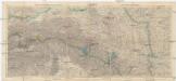
Galizien 1:750 000
1 : 750000 Halič (Polsko a Ukrajina) Artaria
Übersichtskarte von Mittel - Europa

Carte géológique du bassin de la Gallicie et de la Podolie autrichienne
1 : 1028000 Halič (Polsko a Ukrajina) Edler von Lilienbach, Karel Lill Tardieu, Ambroise
Galizien
1 : 3250000 Halič (Polsko a Ukrajina)
Galizien nach den neuesten Beobachtungen
1 : 1390000 Halič (Polsko a Ukrajina) Mollo, Tranquillo Tranquillo Mollo
Galizien nach den neuesten Beobachtungen
1 : 1390000 Halič (Polsko a Ukrajina) Mollo, Tranquillo Tranquillo Mollo
Časové válečné obrazy r. 1914/1915 Illustrovaných novin lipských (Leipziger Illustrierte Zeitung)
Karpaty-oblast
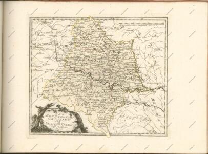
Carte nouvelle des royaumes de Galizie et Lodomerie avec le district de Bukowine
1 : 956000 Bukovina (Rumunsko a Ukrajina) Probst, Johann Michael chez Iean Michel Probst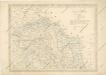
Strassen und Eisenbahnkarte des oesterreichischen Kaiserthumes
Mappa generalis regni Hungariae partiumque adnexarum Croatiae, Slavoniae...
Augustissimo Romanor. Imperatori Iosepho I. Hungaria Regi Invictissimo Mappam Hanc Regni Hungariae
1 : 540000 Mollova mapová sbírka Müller, Johann Christoph
Carte de la Roumanie et pays limitrophes. Lemberg
1 : 500000 France. Service géographique de l'armée [Paris] : Service géographique de l'armée
Bez titulu: Šest listů speciálních map Ukrajiny

Pohlen, Rußland, Gallicien, Wolhinien, Podolien. Ungarn. Ungvárer Comitat
Ungarn Verkehrsweg
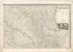
Tarnopol, Brody, Stryj, Czernowitz
1 : 750000 Brody (Ukrajina) Erben, F. K. u. k. Militärgeographisches Institut
Tarnopol, Brody, Stryj, Czernowitz
1 : 750000 Brody (Ukrajina) Erben, F. K. u. k. Militärgeographisches Institut
Tarnopol, Brody, Stryj, Czernowitz
1 : 750000 K. u. k. militär-geographisches Institut
Tarnopol, Brody, Stryj, Czernowitz
1 : 750000 Brody (Ukrajina) K. k. militär-geographisches Institut
Galizien, Östlicher Theil und Bukowina
1 : 700000 Bukovina (Rumunsko a Ukrajina) Karl Fr. Pfau
Strassen- und Eisenbahnkarte des oesterreichischen Kaiserthumes
1 : 864000 Blatt 4 Schaller, G. K.K. Militärisch-Geografisches Institut, Karten-Evidenthaltungs-Abteilung
V, uit: General-Karte des oesterreichischen Kaiserstaates mit einem grossen Theile der angrenzenden Länder / durch Josef Scheda ... bearb. und hrsg
1 : 576000 Annotatie geografische gegevens: Maatstokken: oesterreichische Meilen, geografische oder deutsche Meilen, preussische Meilen, türkische Berri, französische Lieues, russische Werste; Maatstok per blad: wiener Klafter, öster. Meilen; Blad XIX: statistische en taalkundige informatie; Blad XIX: legenda [Wien : K.K. Militärisch-Geografisches Institut]
Übrige Länder der ehemaligen Österreich-Ung. Monarchie
1 : 900000 Halič (Polsko a Ukrajina) Koch, Wilhelm Opitz, Carl Arnd
Nr. 6b. Kämpfe in Ostgalizien. Im Dnjestrgebiet
Galizien Weltkrieg <1914-1918>, Ostfront
Ost Galizien
Halič (Polsko a Ukrajina) Liesganig, Joseph m Verlage des Kunst- und Industrie- Comptoirs