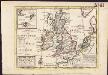
Maps of United Kingdom


[Die Britischen Inseln: Übersicht der Völker und Sprachen]
Zweiter Band, enthaltend in vier Abtheilungen die Vertheilung der Organismen: 5. Pflanzen-Geographie, 6. Thier-Geographie, 7. Anthropographie, 8. Ethnographie Humboldt, Alexander von Verlag von Justus Perthes
Les isles Britanniques
1 : 2600000 Anglie Sanson, Guillaume Boazius, I.B. chez H. Iaillot
Die Brittischen Inseln und die Nord-See
Hand-Atlas über alle Theile der Erde nach dem neuesten Zustande und über das Weltgebäude Stieler, Adolf bei Justus Perthes
Die Britischen Inseln und die Nord-See
Hand-Atlas über alle Theile der Erde nach dem neuesten Zustande und über das Weltgebäude Stieler, Adolf bei Justus Perthes
Isles Britanniques ou sont le Rme. d'Angleterre.
1 : 2600000 L'Isle, Guillaume de, 1675-1726
Die Britischen Inseln und das Umliegende Meer
Hand-Atlas über alle Theile der Erde und über das Weltgebäude Stieler, Adolf Justus Perthes
45-46. Gran Bretagna.
1 : 3000000 Touring club italiano
Britannia prout divisa fuit temporibus Anglo-Saxonum, praesertim durante illorum Heptarchia [Karte], in: Theatrum orbis terrarum, sive, Atlas novus, Bd. 4, S. 87.
1 Karte aus Atlas Blaeu, Joan Blaeu, Willem Janszoon
LES ISLES BRITANNIQUES
1 : 2500000 Anglie Jaillot, Alexis-Hubert H. Iaillot
Die Britischen Inseln Und Das Umliegende Meer.
1 : 3700000 Petermann, A.
Britische Inseln
Adolf Stieler's Handatlas über alle Theile der Erde und über das Weltgebäude Stieler, Adolf Justus Perthes
Nieuwe kaart der Britsche Eilanden Engeland, Schotland en Irland.
1 : 6000000 [S.l.] : [s.n.]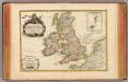
Isles Britanniques.
1 : 3800000 Janvier, Jean
Les Isles Britanniques : ou sont le royaumes d'Angleterre tiré de Speed, celuy d'Ecosse tiré de Th. Pont et celuy d'Irlande tiré de Petit / le tout rectifié par diverses observations par G. de l'Isle
1 : 2650000 titelvariant: Magnae Britanniae tabula; Annotatie: Titel boven de kaart: Magnae Britanniae tabula : comprehendens Angliae, Scotiae, ac Hiberniae regna, ad usum serenissimi Burgundiae Ducis; Oorspr. verschenen in: Atlas nouveau ... / par Guillaume de l'Isle. - Amsterdam : Jean Covens & Corneille Mortier, 1730 Isle, Guillaume de l' Amsteldam : I. Covens & C. Mortier
58-59. Great Britain and Ireland. The World Atlas.
1 : 2500000 USSR (Union of Soviet Socialist Republics).
Anglia, Scotia et Hibernia. [Karte], in: Atlas, sive, Cosmographicae meditationes de fabrica mundi et fabricati figura, S. 80.
1 Karte aus Atlas Mercator, Gerhard
Isles britanniques
1 Karte : Kupferdruck ; 31 x 41 cm Mentelle; Tardieu Mentelle
Isles britanniques
1 Karte : Kupferdruck ; 31 x 41 cm Mentelle; Tardieu Mentelle
A general map of Great Britain and Ireland.
1 : 7500000 Moll, Herman, d. 1732
Nieuwe kaart van de eilanden van Groot Brittannien : behelzende de koningryken Engeland, Schotland en Ierland / volgens de laatste waarnemingen in het ligt gebragt ; C. Sepp del. et sculps. 1743
1 : 3500000 Annotatie: Oorspr. verschenen in: Nieuwe hand-atlas ... - Amsterdam : Isaak Tirion, 1744 Sepp, C. Te Amsterdam : by Isaak Tirion
Anglia, Scotia et Hibernia. [Karte], in: Gerardi Mercatoris Atlas, sive, Cosmographicae meditationes de fabrica mundi et fabricati figura, S. 82.
1 Karte aus Atlas Mercator, Gerhard Montanus, Petrus
Die Britischen Inseln: Volker und Sprachen.
1 : 3800000 Berghaus, Heinrich
Les Isles Britanniques
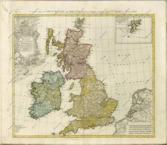
A general map of Great Britain and Ireland, with part of Germany, Holland, Flanders, France &c. agreeable to modern history
1 : 6500000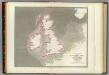
Tidal chart British Seas.
1 : 4900000 Russell, J. Scott (John Scott), 1808-1882
Britannia prout divisa fuit temporibus Anglo-Saxonum praesertim durante illorum Heptarchia. [Karte], in: Le théâtre du monde, ou, Nouvel atlas contenant les chartes et descriptions de tous les païs de la terre, Bd. 4, S. 81.
1 Karte aus Atlas Blaeu, Willem Janszoon und Blaeu, Joan Blaeu, Willem Janszoon
Tidal Chart of the British Seas
The physical atlas Johnston, Alexander Keith William Blackwood & Sons
Iles Britanniques.
1 : 2500000 Vivien St Martin, L.