Maps of Spain


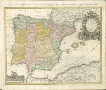
REGNORUM HISPANIAE et PORTUGALLIAE Tabula generalis
1 : 2700000 Aragonie (Španělsko) Homann, Johann Baptist Delisle, Guillaume a Ioh. Bapt. Homanno
REGNORUM HISPANIAE et PORTUGALLIAE Tabula generalis
1 : 2700000 Aragonie (Španělsko) Homann, Johann Baptist Delisle, Guillaume a Ioh. Bapt. Homanno
Portugal et Hispania : ex archetypo Roderici Mendez Silvae et variis relationibus et chartis manu scriptis et impressis huius Regni rectificatis per Observationes Sociorum Academiae Scieiniarum quae est Parisiis
1 : 3200000 per G. de L'Isle Aug. Vind : in officina Tobiae Conr. Lotter
Die iberische Halbinsel bis in die Mitte des XIIIten Jahrhundert's.
1 : 3800000 Spruner von Merz, Karl
Coasts Spain, Portugal, Barbary.
1 : 3200000 Faden, William, 1750?-1836
Carte administrative, physique et routiere de l'Espagne et du Portugal indiquant les canaux, les rivieres naviables, les routes de poste et les nouvelles divisions des provinces, &c.
1 Mapa, col. Orla amb 32 vistes de ciutats i monuments. - Limits acolorits Dufour, A.-H. Dufour, Bulla et Jouy
Emirat von Cordoba bis zum Untergange der Ommijaden; christlichen Reiche im Norden der iberischen Halbinsel 711 bis 1028.
1 : 3700000 Spruner von Merz, Karl
A new & exact map of Spain and Portugal, divided into its kingdoms and principalities &c. ...
from The world described, or, A new and correct sett of maps : shewing the kingdoms and states in all the known parts of the earth, with the principal cities, and most considerable towns in the world ... / ... by Herman Moll, geographer ...
Hispania : ex archetypo Roderici Mendez Silvae et variis relationibus et chartis manu scriptis et impressis hujus regni rectificatis per Observationes Sociorum Academiae Scientiarum quae est Parisiis
1 : 3200000 per G. De L'Isle Matth. Seutter sculp. Aug. Vind : in officina Tobiae Conr. Lotter
Carte des royaumes d'Espagne et de Portugal
1 : 1700000 Portugalsko
Tabula Moderna Hispanie [Karte], in: [Clavdii Ptholomei Cosmographi ...], S. 251.
1 Karte aus Atlas Nicolaus Germanus [und Ptolemaeus, Claudius]
Mapa de la guia oficial de ferro-carriles de España, Francia y Portugal
1 : 4000000 Ferreiro, Martin 1830-1896
Hispania
1 Karte : Kupferdruck ; 48 x 55 cm L'Isle; Seutter; Silva Matthäus Seutter
Carta itineraria de España
1 : 1500000 Depósito Central de Planos de la Dirección General de Obras Públicas
Mapa general de España Antiqua, dividido en tres partes, Bética, Lusitánia y Tarraconénse, con la subdivision de cada una
1 : 3700000 por [...] Juan Lopez, pensionista de S.M [...] Madrid : [Thomas Lopez]
Hispania III. Nova Tabula [Karte], in: Claud. Ptolemaeus. Geographia lat. cum mappis [...], S. 338.
1 Karte aus Atlas Münster, Sebastian [und Ptolemaeus, Claudius]
Die iberische Halbinsel seit dem Anfange des XVIten. Jahrhundert's (1479).
1 : 3800000 Spruner von Merz, Karl
Die iberische Halbinsel 1257 bis 1479.
1 : 3800000 Spruner von Merz, Karl
Carte générale de l'Espagne et du Portugal / par A.H. Brué
1 Mapa. Atlas universel; 22 Brué. Adrien-Hubert chez l'auteur et chez Simonneau
Hispanie ex archetypo Roderici Mendez Sylvae et variis relationibus manu scriptis et impresis hujus regni, emendatis per observationes Sociorum academiae scientiarum quae est Parisiis
1 : 2590000 Portugalsko Delisle, Guillaume Mendes Silva, Rodrigo cura et sumptibus Matth. Seutteri
Hispania III. Nova Tabula [Karte], in: Geographia universalis vetus et nova complectens Claudii Ptolemaei Alexandrini enarrationis libros VIII, S. 308.
1 Karte aus Atlas Münster, Sebastian [und Ptolemaeus, Claudius]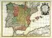
Hispania
1 Karte : Kupferdruck ; 43 x 60 cm Lotter; L'Isle; Seutter; Silva in officina Tobiæ Conr: Lotter calcogr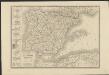
Carte d'Espagne et de Portugal divisée suivant la décision des cortès et soumise aux dernières observations
1 : 2250000 par J. B. Poirson Paris : chez A. Bes et F. Dubreul
L'Espagne
1 Karte : Kupferdruck ; 47 x 59 cm L'Isle; Luchtenburg; Silva chez I. Covens et C. Mortier
España: comunicaciones terrestres
Datat al 1950 aproximadament. 0 Seix y Barral
Spanien und Portugal
E. von Sydow's Schul-Atlas in sechs und dreissig Karten Sydow, Emil von bei Justus Perthes
[Spanien und Portugal, Iberische Halbinsel]
Geographischer Atlas über alle Theile der Erde Ziegler, Jakob Melchior Verlag von Dietrich Reimer