Maps of Nitriansky

Die Donau, der Fürst aller Europaeischen Flüsse :
Mollova mapová sbírka Hoffmann, Johannes Hoffmann, Johann
Generalkarte von Zentraleuropa

Barser und Honther Comitat
1 : 290000 Levice (Slovensko : oblast)
Barser und Honther Comitat
1 : 288000 Levice-oblast (Slovensko)
Unter Neutraer-Comitat
1 : 280000 Nitra-oblast (Slovensko)
Unter Neutraer-Comitat
1 : 290000 Nitra (Slovensko : oblast)
Stolice Tekov. Stolice Hont
Komitat Hont, Komitat Bars, ethnische Gruppe
C. Barsensis
Slowakei Komitat Bars
Mappa Comitatvs Hontensis Methodo Astronomico-Geometrica concinnata.
1 : 160000 Mollova mapová sbírka Mikoviny, Sámuel Nicolaï, Georg David Christoph
Mappa Comitatvs Barsiensis Methodo Astronomico-Geometrica concinnata.
1 : 160000 Mollova mapová sbírka Mikoviny, Sámuel Nicolaï, Georg David Christoph
Mappa Comitatis Hontensis Methodo Astronomico-Geometrica concinnata, opera ...
1 : 162000 Mollova mapová sbírka Mikoviny, Sámuel
Schemnitz 134, uit: Special-Karte von Mittel-Europa / nach amtlichen Quellen bearbeitet von W. Liebenow
1 : 300000 titelvariant: W. Liebenow's Mittel-Europa; Annotatie: Titel boven de bladen: W. Liebenow's Mittel-Europa Johannes Wilhelm Liebenow 1822-1897 Frankfurt a. M. : Ludwig Ravenstein
Generální mapa ČSR

C. Nitriensis. Tab. I
Slowakei Komitat Neutra
C. Strigontensis
Ungarn Komitat Gran (Ungarn)

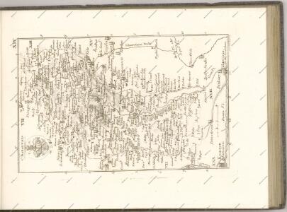
Mappa Comitatvs Nitriensis :
1 : 170000 Mollova mapová sbírka Mikoviny, Sámuel Nicolaï, Georg David Christoph
Komorn 148, uit: Special-Karte von Mittel-Europa / nach amtlichen Quellen bearbeitet von W. Liebenow
1 : 300000 titelvariant: W. Liebenow's Mittel-Europa; Annotatie: Titel boven de bladen: W. Liebenow's Mittel-Europa Johannes Wilhelm Liebenow 1822-1897 Frankfurt a. M. : Ludwig Ravenstein
C. Hontensis
Slowakei Komitat Hont
Vestigium Operationis Astronomico-Geometricae :
1 : 533000 Mollova mapová sbírka
Komorner Comitat
1 : 290000
Komorner Comitat
1 : 288000 Komárno (Slovensko)
Komárom vármegye térképe
1 : 360000 Kogutowicz, Manó Magyar Földrajzi Intézet
Mappa comitatus Hontensis
1 : 170000 Hont-oblast (Slovensko) Mikoviny, Sámuel Nicolai, Georg David Christoph
Hont vármegye
1 : 288000 Hont (Slovensko a Maďarsko) Biller, Bernhard Görög
Leva und Sallo. (Ungarn)
from Spezialkarte der osterreichisch-ungarischen Monarchie.
Handlova und Oszlany (Ungarn).
from Spezialkarte der osterreichisch-ungarischen Monarchie.