Maps of District of Námestovo
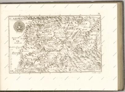
C. Arvensis
Slowakei Polen Komitat Arva
Borsod vármégye térképe
1 : 375000 Kogutowicz, Manó Magyar Földrajzi Intézet
Turdossin an der Arva.
from Spezialkarte der osterreichisch-ungarischen Monarchie.
III. vojenské mapování 4263
1 : 75000
Oravsko-Liptovské hory

Turdossin
1 : 75000 Tvrdošin, Umland
Tvrdošín
1 : 75000 Slovensko Kartografické odd. při Min. Nár. Obrany
[Gradkartenblatt]
1 : 25000 Orava (Polsko a Slovensko) Vojenský zeměpisný ústav
[Gradkartenblatt]
1 : 25000 Dolný Kubín-oblast (Slovensko) Vojenský zeměpisný ústav
[Gradkartenblatt]
1 : 25000 Dolný Kubín-oblast (Slovensko) Vojenský zeměpisný ústav
III. vojenské mapování 4363/2
1 : 25000
[Gradkartenblatt]
1 : 25000 Dolný Kubín-oblast (Slovensko) Vojenský zeměpisný ústav
[Gradkartenblatt]
1 : 25000 Dolný Kubín-oblast (Slovensko) Vojenský zeměpisný ústav
III. vojenské mapování 4364/1
1 : 25000
Ujsoly und Stara-Bistrica.; Spezialkarte der osterreichisch-ungarischen Monarchie.
from Spezialkarte der osterreichisch-ungarischen Monarchie. Austro-Hungarian Monarchy. Militärgeographisches Institut.,
Ujsoły und Stara-Bistrica
1 : 75000 Stará Bystrica, Schlesische Beskiden Schrift und Gerippe v. Dokaupil. Terrainschraffirung v. Hptm. R. Jonak Edl. v. Freyenwald
Stará Bystrica
1 : 75000 Orava (Polsko a Slovensko) Vojenský zeměpisný ústav
III. vojenské mapování 4262
1 : 75000
Stará Bystrica
1 : 75000 Slovensko Vojenský zeměpisný ústav
Ujsoły und Stara-Bistrica
1 : 75000 Polsko Dokaupil K. u. k. Militär-geographisches Institut
Mapa gospodarczo-osadnicza pasterstwa w Tatrach = Carte de la vie économique des bergers et leurs établissements dan les Tatra : i mapka etnograficzna z zasięgem wędrówek pasterskich i typów szałaśniczych : et petite carte ethnographique avec l'extension des migrations pastorales et des types des chalets
1 : 75000 Holub-Pacewiczowa, Zofia; Wojskowy instytut geograficzny [Warszawa] : Wojsk. Instyt. Geograf.
Liptó Szt. Miklós
1 : 75000 Liptovský Mikuláš (Slovensko : oblast) Militärgeographisches Institut
Lipto Szt. Miklos (Ungarn).; Spezialkarte der osterreichisch-ungarischen Monarchie.
from Spezialkarte der osterreichisch-ungarischen Monarchie. Austro-Hungarian Monarchy. Militärgeographisches Institut.,
Liptó szt. Miklós
1 : 75000 Liptovský Mikulaš, Umland Geripp: J. Mugerauer. Terrain: Oberlt. Sachs
III. vojenské mapování 4363
1 : 75000
[Gradkartenblatt]
1 : 25000 Slovensko Vojenský zeměpisný ústav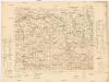
Chyżne SO
1 : 25000 Polsko Reichsamt für Landesaufnahme
III. vojenské mapování 4363/1
1 : 25000