Maps of Wales

Occidentalior regni Angliæ districtus
1 Karte : Kupferdruck ; 56 x 48 cm Wit ex officina I. Cóvens et C. Mortier
Occidentalior regni Angliæ districtus
1 Karte : Kupferdruck ; 57 x 48 cm Wit Frederick de Wit
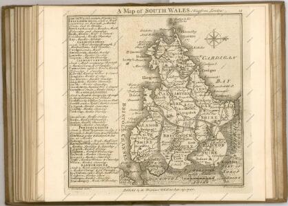
England & Wales, south-western section; Scilly Isles.
1 : 633600 John Bartholomew & Co.
England & Wales SW.
1 : 633600 Stanford, Edward
Westmorlandia, Lancastria, Cestria, Caernarvan, Denbigh, Flint, Merionidh, Montgomery, Salopia cum insulis Mania et Anglesey
1 Karte : Kupferdruck ; 34 x 40 cm Mercator; Hondius Henricus Hondius
Westmorlandia, Lancastria, Cestria, Caernarvan, Denbigh, Flint, Merionidh, Montgomery, Salopia cum insulis Mania, et Anglesey
1 Karte : Kupferdruck ; 17 x 24 cm Mercator Cloppenburgh
Westmorlandia, Lancastria, Cestria, Caernarvan, Denbigh, Flint, Merionidh, Montgomery, Salopia cum insulis Mania et Anglesey
1 Karte : Kupferdruck ; 34 x 40 cm Mercator; Hondius Jodocus Hondius
Charte von England und Wallis, 3
1 Blatt : 62 x 53 cm Walch
Karte von England und Wallis, 3
1 Blatt : 62 x 53 cm Schrämbl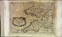
Cornvbia, Devonia, Somersetvs, Dorcestia, Wiltonia, Glocestra Monvmetha, Glamorgan, Caermarden, Penbrok, Cardigan, Radnor, Breknoke, Herefordia, [et] Wigornia
1 Karte : Kupferdruck ; 17 x 24 cm Keere; Mercator Cloppenburgh
Cornvbia, Devonia, Somersetvs, Dorcestria, Wiltonia, Glocestria Monvmetha, Glamorgan, Caermarden, Penbrok, Cardigan, Radnor, Breknoke, Herefordia, [et] Wigornia
1 Karte : Kupferdruck ; 35 x 45 cm Hondius; Mercator Henricus Hondius
Cornvbia, Devonia, Somersetvs, Dorcestria, Wiltonia, Glocestria Monvmetha, Glamorgan, Caermarden, Penbrok, Cardigan, Radnor, Breknoke, Herefordia, [et] Wigornia
1 Karte : Kupferdruck ; 35 x 45 cm Mercator; Hondius Jodocus Hondius
Westmorlandia, Lancastria, Cestria, Caernarvan, Denbigh, Flint, Merionidh, Montogomery, Salopia Cum insulis Mania Et Anglesey. [Karte], in: Atlas, sive, Cosmographicae meditationes de fabrica mundi et fabricati figura, S. 113.
1 Karte aus Atlas Mercator, Gerhard
Principauté de Galles
1 Karte : Kupferdruck ; 36 x 42 cm Sanson; Fortin chez le Sr. Fortin ing.r pour les globes rue de la Harpe près celle du Foin
Principauté de Galles
1 Karte : Kupferdruck ; 36 x 42 Sanson chez l'autheur
Watershed map England, Wales 3.
1 : 760320 Letts, Son & Co.
Westmorlandia, Lancastria, Cestria, Caernarvan, Denbigh, Flint, Merionidh, Montogomery, Salopia Cum insulis Mania Et Anglesey. [Karte], in: Gerardi Mercatoris Atlas, sive, Cosmographicae meditationes de fabrica mundi et fabricati figura, S. 115.
1 Karte aus Atlas Mercator, Gerhard Montanus, Petrus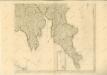

WALLIA | PRINCIPATVS | Vulgo WALES.
[Amsterdam : Joan Blaeu]


Cambriae typus
1 : 780000
Cornubia, Devonia, Somersetus, Dorcestria, Wiltonia, Glocestria, Monumetha, Glamorgan, Caermarden, Penbrok, Cardigan, Radnor, Breknoke, Herefordia, & Wigornia. [Karte], in: Atlas, sive, Cosmographicae meditationes de fabrica mundi et fabricati figura, S. 116.
1 Karte aus Atlas Mercator, Gerhard
Wallia principatvs vulgo Wales
1 Karte : Kupferdruck ; 37 x 48 cm Blaeu Joan Blaeu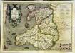
Cambriae typus
1 Karte : Kupferdruck ; 33 x 48 cm Lhuyd; Keere; Mercator; Hondius Henricus Hondius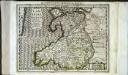
Cambriae typus
1 Karte : Kupferdruck ; 17 x 24 cm Lhuyd; Keere; Mercator Cloppenburgh
Cambriae typvs
1 Karte : Kupferdruck ; 35 x 47 cm Lhuyd; Ortelius s.n.
Cambriae typvs
1 Karte : Kupferdruck ; 35 x 47 cm Lhuyd; Ortelius s.n.